Rosendaël
| Rosendaël | ||
|---|---|---|
|
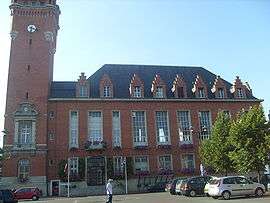
Town hall annex | ||
| ||
 Rosendaël | ||
|
Location within Hauts-de-France region  Rosendaël | ||
| Coordinates: 51°02′29″N 2°24′13″E / 51.0413°N 2.4037°ECoordinates: 51°02′29″N 2°24′13″E / 51.0413°N 2.4037°E | ||
| Country | France | |
| Region | Hauts-de-France | |
| Department | Nord | |
| Arrondissement | Dunkirk | |
| Canton | Dunkirk-East | |
| Intercommunality | Dunkerque grand littoral | |
| Government | ||
| • Mayor (2008–2014) | Alain Vanwaefelghem (deputy mayor) | |
| Area1 | 3.97 km2 (1.53 sq mi) | |
| Population (1999)2 | 18,272 | |
| • Density | 4,600/km2 (12,000/sq mi) | |
| Time zone | CET (UTC+1) | |
| • Summer (DST) | CEST (UTC+2) | |
| INSEE/Postal code | 59510 / 59240 | |
|
1 French Land Register data, which excludes lakes, ponds, glaciers > 1 km² (0.386 sq mi or 247 acres) and river estuaries. 2 Population without double counting: residents of multiple communes (e.g., students and military personnel) only counted once. | ||
Rosendaël (Rozendaal in Dutch) is a former commune in the Nord department in northern France. In 1972 it was merged into Dunkirk. According to François-Joseph Grille, the name means "Rose Valley" . It currently has 18,272 inhabitants (an almost ten-fold increase since 1825) in an area of 3.97 km2.
Heraldry
_Nord-France.svg.png) |
The arms of Rosendaël are blazoned : D'azur à la Rose d'Argent |
Rosendaël also has its own flag, Barry of 6 gules and vert
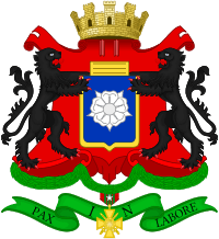 Grandes armes de Rosendaël.
_Nord-France.svg.png) Flag of Rosendaël
Flag of Rosendaël Flag of Rosendaëlsur dam
See also
This article is issued from Wikipedia - version of the 9/19/2016. The text is available under the Creative Commons Attribution/Share Alike but additional terms may apply for the media files.