Ross Island
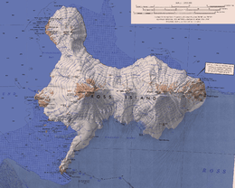 Map of Ross Island | |
 Ross Island | |
| Geography | |
|---|---|
| Location | Antarctica |
| Coordinates | 77°30′S 168°00′E / 77.500°S 168.000°ECoordinates: 77°30′S 168°00′E / 77.500°S 168.000°E |
| Archipelago | Ross Archipelago |
| Area | 2,460 km2 (950 sq mi) |
| Highest elevation | 3,794 m (12,448 ft) |
| Highest point | Mount Erebus |
| Administration | |
|
None | |
| Demographics | |
| Population | 100 |
| Additional information | |
| Administered under the Antarctic Treaty System | |
Ross Island is an island formed by four volcanoes in the Ross Sea near the continent of Antarctica, off the coast of Victoria Land in McMurdo Sound.
Geography
Because of the persistent presence of the ice sheet, the island is sometimes taken to be part of the Antarctic mainland. Its area is 2,460 square kilometres (950 sq mi); only a small portion of the island is free of ice and snow. The planet's southernmost active volcano, Erebus (3,794 m or 12,448 ft), as well as the dormant volcano Terror (3,230 m or 10,597 ft), are situated on the island. They were named by Ross after his ships HMS Erebus and HMS Terror. The third highest elevation is Mount Bird, with Shell Glacier and Endeavour Piedmont Glacier on its slopes. Abbott Peak stands between Mount Erebus and Mount Bird. Gamble Cone stands in the east of the island.[1]
Despite its relatively small size, Ross Island is the world's 6th highest island. It has the highest average elevation of any island.
Landmarks
The Alcorta Rocks (77°30′S 166°22′E / 77.500°S 166.367°E) is a nunatak on the east shore of Maumee Bight, Ross Island, 2.6 kilometres (1.6 mi) east-northeast of Rocky Point. The feature rises to about 100 metres (330 ft) and is distinctive because three ridges radiate from the center. The rocks were named by the Advisory Committee on Antarctic Names in the year 2000 after Jesse J. Alcorta, a year-round support employee with eight field seasons at McMurdo Station from 1992–93 and many trips to South Pole Station; hazardous waste handling specialist at both McMurdo Station and South Pole Station; and cryogenic technician in support of the United States Antarctic Program laboratories.[2]
Discovery
Sir James Clark Ross discovered it in 1840, and it was later named in honour of him by Robert F. Scott.
Ross Island was the base for many of the early expeditions to Antarctica. It was and still is the southernmost island reachable by sea. Huts built by Scott's and Shackleton's expeditions are still standing on the island, preserved as historical sites.
Today Ross Island is home to New Zealand's Scott Base, and the largest Antarctic settlement, the U.S. Antarctic Program's McMurdo Station. Greenpeace established World Park Base on the island and ran it for five years, from 1987 to 1992.
Gallery
.svg.png) Orthographic projection centred over Ross Island
Orthographic projection centred over Ross Island Land fast sea ice in the foreground. Ross Island in the background. 77° 30′ S Latitude 168° 00′ E Longitude.
Claims
Ross Island lies within the boundaries of Ross Dependency.
Wildlife
Ross Island supports a colony of approximately half a million Adélie penguins.
See also
- Composite Antarctic Gazetteer
- Erebus hotspot
- Erebus Ice Tongue
- List of Antarctic and sub-Antarctic islands
- List of Antarctic islands south of 60° S
- List of islands of New Zealand
- McMurdo Sound
- New Zealand Subantarctic Islands
- Ross Sea
- Ross Bank
- SCAR
- Territorial claims in Antarctica
- Air New Zealand Flight 901
References
- ↑ LeMasurier, W. E.; Thomson, J. W., eds. (1990). Volcanoes of the Antarctic Plate and Southern Oceans. American Geophysical Union. p. 512. ISBN 0-87590-172-7.
- ↑ Name Details: Alcorta Rocks (New Zealand Gazetteer) AADC
External links
| Wikimedia Commons has media related to Ross Island. |
- Map of Ross Island and Dry Valleys, NIWA New Zealand
- Coastal-change and Glaciological Map of the Ross Island Area, Antarctica, 1962-2005 United States Geological Survey