Vermont Route 25
| ||||||||||
|---|---|---|---|---|---|---|---|---|---|---|
|
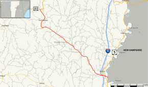
Map of Orange County in eastern Vermont with VT 25 highlighted in red | ||||||||||
| Route information | ||||||||||
| Maintained by VTrans | ||||||||||
| Length: | 17.739 mi[1] (28.548 km) | |||||||||
| Existed: | 1926 – present | |||||||||
| Major junctions | ||||||||||
| South end: |
| |||||||||
|
| ||||||||||
| North end: |
| |||||||||
| Location | ||||||||||
| Counties: | Orange | |||||||||
| Highway system | ||||||||||
| ||||||||||

Vermont Route 25 is a state highway in Orange County, Vermont, United States. It begins at the New Hampshire state line in Bradford, continuing across the Connecticut River as New Hampshire Route 25, and ends in Orange at U.S. Route 302.
Route description
VT 25 begins at the New Hampshire state line just south of the village of Bradford. The road continues across the state line at the Connecticut River as New Hampshire Route 25. About 0.5 miles (0.8 km) west of the state line, VT 25 intersects with U.S. Route 5, which leads to the town center. Soon after, VT 25 has an interchange with I-91 at Exit 16, then an intersection with VT 25B, a spur route leading from southbound VT 25 towards Bradford village. VT 25 continues in a northwest direction following the path of the Waits River. It travels through mainly rural areas, passing through the small settlements of Bradford Center and East Corinth. VT 25 crosses the Waits River near the Corinth-Topsham town line, where it continues following the river through the communities of Waits River and West Topsham. VT 25 ends about 0.3 miles (0.48 km) after crossing into the town of Orange, where it ends at an intersection with U.S. Route 302.
History

Vermont Route 25 used to be known as New England Route 25A, an alternate route of New England Route 25 from Topsham through Bradford. It connected back to the main New Hampshire section of Route 25 via an overlap with New Hampshire Route 10. Within Vermont, the main route of New England Route 25 was assigned in 1926 to U.S. Route 2. At the same time, Vermont renumbered 25A to 25. In 1935, US 2 in Vermont was relocated to a more northerly alignment and the former New England Route 25 was redesignated as U.S. Route 302.
Major intersections
The entire route is in Orange County. [1]
| Location[1] | mi[1] | km | Destinations | Notes | |
|---|---|---|---|---|---|
| Bradford | 0.000 | 0.000 | Continuation into New Hampshire | ||
| 0.496 | 0.798 | ||||
| 0.984– 1.176 | 1.584– 1.893 | Exit 16 on I-91 | |||
| 1.694 | 2.726 | Western terminus of VT 25B | |||
| Orange | 17.739 | 28.548 | |||
| 1.000 mi = 1.609 km; 1.000 km = 0.621 mi | |||||
Suffixed routes
Vermont Route 25A
| |
|---|---|
| Location: | Fairlee |
| Length: | 0.088 mi[1] (0.142 km) |
Vermont Route 25A (VT 25A) in Fairlee is the 0.088-mile (0.142 km)[1] westward extension of New Hampshire Route 25A. It is unrelated to VT 25 but is related to NH 25.
Vermont Route 25B
| |
|---|---|
| Location: | Bradford |
| Length: | 0.981 mi[1] (1.579 km) |
Vermont Route 25B (VT 25B) is a 0.981-mile (1.579 km)[1] spur of southbound VT 25 towards the village of Bradford, which VT 25 bypasses. VT 25B ends at U.S. Route 5. It was named VT 25B because VT 25A already exists. It is the only spur route related to VT 25.
See also
-
 Vermont portal
 -
 U.S. Roads portal
References
- 1 2 3 4 5 6 7 8 Traffic Research Unit (May 2013). "2012 (Route Log) AADTs for State Highways" (PDF). Policy, Planning and Intermodal Development Division, Vermont Agency of Transportation. Retrieved March 11, 2015.
External links
-
 Media related to Vermont Route 25 at Wikimedia Commons