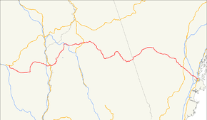
U.S. Route 302
| |
|---|---|
|
William Scott Memorial Highway [1] Roosevelt Trail[2] | |
 | |
| Route information | |
| Auxiliary route of US 2 | |
| Length: | 171 mi (275 km) |
| Existed: | 1935[3] – present |
| Major junctions | |
| West end: |
|
| |
| East end: |
|
| Location | |
| States: | Vermont, New Hampshire, Maine |
| Highway system | |

U.S. Route 302 (US 302) is an east–west spur of U.S. Route 2 in northern New England in the United States. It currently runs 171 miles (275 km) from Montpelier, Vermont, at US 2, to Portland, Maine, at U.S. Route 1. It passes through the states of Vermont, New Hampshire and Maine.
Route description
| mi[4][5] | km | |
|---|---|---|
| VT | 35.746 | 57.528 |
| NH | 79.155 | 127.388 |
| ME | 53.9 | 86.7 |
| Total | 168.801 | 271.659 |

Vermont
US 302 enters Vermont after crossing the Connecticut River at the village of Wells River. The highway crosses US 5 in the center of the village. The next major intersection for US 302 is its intersection with Interstate 91 in Newbury, about 2.7 miles (4.3 km) from the US 5 intersection. US 302 then winds through the rural towns of Ryegate, Groton, Topsham, and Orange, before entering East Barre. In East Barre, its intersection with Vermont Route 110 takes the form of a roundabout. After traveling down out of the hills surrounding the city of Barre, US 302 makes up Washington Street and Main Street of Barre. It runs along the Jail Branch River and the Stevens Branch of the Winooski River in Barre, then through Berlin, finally terminating at its US 2 intersection in southeast Montpelier.
New Hampshire
U.S. Route 302 enters New Hampshire following the Saco River through Crawford Notch in the White Mountains. The highway follows the Ammonoosuc River out of the mountains and bridges the Connecticut River into Wells River, Vermont.
Maine
US 302 is known as the Roosevelt Trail through southern Maine because it was the beginning of the Theodore Roosevelt International Highway to Portland, Oregon.[2][6] The highway leaves Portland, Maine, bridging the Presumpscot River into Westbrook at Riverton. The Roosevelt Trail then bridges the Pleasant River at milepost 13.4 in Windham, the Crooked River in Casco near a boyhood home of Nathaniel Hawthorne, Long Lake near milepost 31 in Naples, Moose Pond near milepost 46 in Bridgton, and the Saco River near milepost 56 in Fryeburg. The highway follows the Saco River from Fryeburg into the White Mountains and enters New Hampshire near milepost 58.[7] It is a two-lane highway for almost all of its length, but there are multi-lane sections within the Portland area, as well as short four-lane sections in and around North Windham (especially the commercial areas). Some of the hilly sections also feature a third passing lane.
History
The southern end of US 302 follows city streets from Longfellow Square in the 17th century colonial seaport of Portland, Maine. The highway follows a 19th-century stagecoach road from Portland through Windham to Bridgton. The portion from Windham to Bridgton was built about 1785. Stagecoach service began in 1803, and the route became a post road for the United States Postal Service in 1814. Transportation over this route was augmented by the Cumberland and Oxford Canal from 1832 to 1932, and by the Bridgton and Saco River Railroad from 1883 to 1941.[8] The highway through Crawford Notch follows the Tenth New Hampshire Turnpike built in 1803 and parallels the Maine Central Railroad Mountain Division built in 1877. The highway eliminated railway passenger travel over the route from Portland by 1958, and railroad freight service through Crawford Notch was discontinued in 1983.[9]

| |
|---|---|
| Location: | Conway, NH—Portland |
| Length: | 54.18 mi (87.19 km) |
| Existed: | 1926–1935 |
From 1922 until 1935, much of what is now US 302 was a part of the New England Interstate road system, designated as New England Interstate Route 18 (NE-18) from Portland, Maine, northwest to Littleton, New Hampshire, roughly 112 miles (180 km). From Littleton west to Montpelier in Vermont, US 302 and NE-18 took different paths. NE-18 took a more northerly route, along present-day New Hampshire Route 18 and Vermont Route 18 to St. Johnsbury, Vermont (closely paralleling I-93), then along present-day US 2 up to Montpelier.
Current US 302 runs along a more southerly route using other former sections of New England Interstate Routes. From Littleton, it went along former NE-10 to Woodsville, New Hampshire, then along former NE-25 to Montpelier.
The entire Maine segment of US 302 was formally designated State Route 18, a route that was established in 1926 until being deleted in 1935 by US 302.
Major intersections
Vermont
| County | Location[4] | mi[4] | km | Destinations | Notes |
|---|---|---|---|---|---|
| Washington | Montpelier | 0.000 | 0.000 | Rotary; western terminus of US 302. | |
| Berlin | 1.059 | 1.704 | Berlin State Highway to | ||
| City of Barre | 4.376 | 7.042 | Western end of concurrency with VT 14; eastern terminus of VT 62. | ||
| 4.833 | 7.778 | Eastern end of concurrency with VT 14. | |||
| Town of Barre | 8.639 | 13.903 | Northern terminus of VT 110 at rotary. | ||
| Orange | Orange | 16.041 | 25.815 | Northern terminus of VT 25. | |
| Caledonia | Groton | 23.928 | 38.508 | Southern terminus of VT 232. | |
| Orange | Town of Newbury | 32.472– 32.681 | 52.259– 52.595 | Exit 17 on I-91. | |
| 35.334 | 56.865 | Western terminus of concurrency with US 5. | |||
| 35.463 | 57.072 | Eastern terminus of concurrency with US 5. | |||
| 35.746 | 57.528 | Continuation into New Hampshire at the Connecticut River | |||
1.000 mi = 1.609 km; 1.000 km = 0.621 mi
| |||||
New Hampshire
Maine
| County | Location | mi | km | Destinations | Notes |
|---|---|---|---|---|---|
| Oxford | Fryeburg | 0.0 | 0.0 | ||
| 1.1 | 1.8 | Northern terminus of concurrency with SR 113. | |||
| 1.4 | 2.3 | Southern terminus of concurrencies with SR 5 and SR 113. | |||
| 1.8 | 2.9 | Northern terminus of concurrency with SR 5. | |||
| Cumberland | Bridgton | 14.9 | 24.0 | Southern terminus of SR 93. | |
| 16.8 | 27.0 | Northern terminus of concurrency with SR 117. | |||
| 18.4 | 29.6 | Southern terminus of concurrency with SR 117. | |||
| Naples | 24.9 | 40.1 | Southern terminus of concurrency with SR 11. Northern terminus of SR 114. | ||
| 25.4 | 40.9 | Northern terminus of concurrency with SR 35. | |||
| 26.3 | 42.3 | Northern terminus of concurrency with SR 11. | |||
| Casco | 27.0– 31.5 | 43.5– 50.7 | No major intersections. | ||
| Raymond | 34.0 | 54.7 | Southern terminus of SR 121. | ||
| 34.4 | 55.4 | Southern terminus of SR 85. | |||
| Windham | 38.8 | 62.4 | Southern terminus of concurrency with SR 35. Western terminus of SR 115. | ||
| 41.7 | 67.1 | Rotary. | |||
| Westbrook | 45.9– 49.7 | 73.9– 80.0 | No major intersections. | ||
| Portland | 50.3 | 81.0 | No access between US 302 and I-95 (Maine Turnpike) | ||
| 51.6 | 83.0 | Northern terminus of concurrency with SR 100. | |||
| 52.9 | 85.1 | Eastern terminus of wrong-way concurrency with SR 9. | |||
| 53.0 | 85.3 | Western terminus of wrong-way concurrency with SR 9. | |||
| 53.9 | 86.7 | Eastern terminus of US 302. Southern terminus of SR 100 and concurrency with SR 100. Northern terminus of SR 77. Exit 6A and 6B on I-295 / US 1. | |||
1.000 mi = 1.609 km; 1.000 km = 0.621 mi
| |||||
See also
Bannered routes
- U.S. Route 302 Business (Bartlett, New Hampshire), a loop connecting US 302 to Lower Bartlett. It is locally known as the Intervale Resort Loop and is signed only as New Hampshire Route 16A.
Related state highways
References
- ↑ "Vermont Named State Highways and Bridges". Vermont Department of Libraries. Retrieved May 21, 2012.
- 1 2 Tracy, A.W. Theodore Roosevelt International Highway (1996) p.7
- ↑ Droz, Robert V. U.S. Highways : From US 1 to (US 830). URL accessed 27 February 2006.
- 1 2 3 Traffic Research Unit (May 2013). "2012 (Route Log) AADTs for State Highways" (PDF). Policy, Planning and Intermodal Development Division, Vermont Agency of Transportation. Retrieved March 9, 2015.
- ↑ Bureau of Planning & Community Assistance (February 20, 2015). "NH Public Roads". Concord, New Hampshire: New Hampshire Department of Transportation. Retrieved April 7, 2015.
- ↑ "U.S. 2: Houlton, Maine, to Everett, Washington". United States Department of Transportation Federal Highway Administration. Retrieved 2011-09-05.
- ↑ Greaton, Everett F. Maine, a Guide "Down East" (1937) pp.375-381
- ↑ Jones, Robert C. Two Feet to the Lakes: The Bridgton & Saco River Railroad (1993) ISBN 0-915713-26-8 pp.12-13
- ↑ Johnson, Ron Maine Central Railroad Mountain Division p.9
| Browse numbered routes | ||||
|---|---|---|---|---|
| ← | VT | VT 313 | ||
| ← | NH | I‑393 | ||
| ← | ME | I‑395 | ||
| ← | N.E. | Route 19 | ||
| ← | SR 22 | |||