Rumelange
| Rumelange Rëmeleng | ||
|---|---|---|
| Commune | ||
 | ||
| ||
 Map of Luxembourg with Rumelange highlighted in orange, and the canton in dark red | ||
| Coordinates: 49°27′35″N 6°01′50″E / 49.4597°N 6.0306°ECoordinates: 49°27′35″N 6°01′50″E / 49.4597°N 6.0306°E | ||
| Country |
| |
| Canton | Esch-sur-Alzette | |
| Government | ||
| • Mayor | Henri Haine | |
| Area | ||
| • Total | 6.83 km2 (2.64 sq mi) | |
| Area rank | 104 of 105 | |
| Highest elevation | 432 m (1,417 ft) | |
| • Rank | 27th of 105 | |
| Lowest elevation | 287 m (942 ft) | |
| • Rank | 91st of 105 | |
| Population (2014) | ||
| • Total | 5,239 | |
| • Rank | 26th of 105 | |
| • Density | 770/km2 (2,000/sq mi) | |
| • Density rank | 8th of 105 | |
| Time zone | CET (UTC+1) | |
| • Summer (DST) | CEST (UTC+2) | |
| LAU 2 | LU00010012 | |
| Website | rumelange.lu | |

Rumelange (Luxembourgish: Rëmeleng, German: Rümelingen) is a commune with town status in south-western Luxembourg, on the border with France. As of the February 1, 2011 census, the commune had a population of 5,038.
As of 2008, the town of Rumelange, which lies in the east of the commune, has a population of 4,818.
Rumelange was formed on 25 September 1891, when it was detached from the commune of Kayl. The law forming Rumelange was passed on the 27 June 1891.[1]
It is the site of some of the underground iron mines no longer in operation. Rumelange is home to Luxembourg's National Mining Museum.[2]
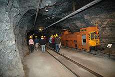
Inside the National Mining Museum
References
- ↑ (French)/(German) "Mémorial A, 1891, No. 38" (PDF). Service central de législation. Retrieved 2006-08-15.
- ↑ "National Mining Museum". Retrieved 20 February 2011.
External links
-
 Media related to Rumelange at Wikimedia Commons
 |
Esch-sur-Alzette | Kayl | | |
| Audun-le-Tiche (FR-57) | |
Kayl | ||
| ||||
| | ||||
| Ottange (FR-57) |
 | ||
This article is issued from Wikipedia - version of the 12/1/2016. The text is available under the Creative Commons Attribution/Share Alike but additional terms may apply for the media files.