Washington State Route 128
| ||||
|---|---|---|---|---|
|
| ||||
| Route information | ||||
| Auxiliary route of US 12 | ||||
| Defined by RCW 47.17.255 | ||||
| Maintained by WSDOT | ||||
| Length: | 2.30 mi[1] (3.70 km) | |||
| Existed: | 1964[2] – present | |||
| Major junctions | ||||
| West end: |
| |||
|
| ||||
| East end: |
| |||
| Highway system | ||||
| ||||

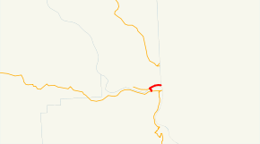
State Route 128 (SR 128) is a Washington state highway located in Asotin and Whitman counties, west of the Idaho state line. The 2.30-mile (3.70 km) long route runs north from U.S. Route 12 (US 12) in Clarkston to cross the Snake River and turn east after intersecting SR 193 to terminate at State Highway 128 (SH 128) on the Idaho state line. The highway was originally created in 1964 on a Pomeroy–Clarkston route, replacing Secondary State Highway 3K (SSH 3K), which had been established in 1937; in 1991, the route was changed to its present form.
Route description
State Route 128 (SR 128) begins at an intersection with U.S. Route 12 (US 12) in Clarkston, a city in Asotin County. The road then crosses the Snake River over the Red Wolf Crossing into Whitman County, where it crosses the Starbuck, WA–Spalding, ID route of the Great Northwest Railroad and intersects the eastern terminus of SR 193.[3][4] At the SR 193 intersection, the highway turns east and continues to the Idaho state line, where it becomes Idaho State Highway 128 (SH-128);[5] which continues for another 2.198 miles (3.537 km) before ending at US-12 north of Lewiston, Idaho.[6][7] SR 128 after the US 12 intersection was used by 5,000 motorists daily in 2007 based on average annual daily traffic (AADT) data collected by the Washington State Department of Transportation.[8]
History
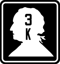
The first highway that would later become SR 128 was Secondary State Highway 3K (SSH 3K), which was first designated in 1937.[9] The road ran from Pomeroy in Garfield County southeast to Peola and later northeast to Clarkston, terminating at Primary State Highway 3 (PSH 3), co-signed with U.S. Route 410 (US 410) at both termini.[9][10] During the 1964 highway renumbering, SSH 3K became SR 128, which ran 42.19 miles (67.90 km);[11][12] the current route of the highway was occupied by SR 193, which was Secondary State Highway 3G from 1969 to 1970. In 1990, SR 193 was shortened from the Red Wolf Crossing to the Idaho state line, which SR 128 was extended over. A year after the extension to Idaho, SR 128 was shortened from Pomeroy to Clarkston along its current route,[13] a loss of 42.19 miles (67.90 km) in total.[12]
Major intersections
| County | Location | mi[1] | km | Destinations | Notes | |
|---|---|---|---|---|---|---|
| Asotin | Clarkston | 0.00 | 0.00 | |||
| Snake River | 0.39 | 0.63 | Red Wolf Crossing | |||
| Whitman | | 0.51 | 0.82 | |||
| | 2.30 | 3.70 | ||||
| 1.000 mi = 1.609 km; 1.000 km = 0.621 mi | ||||||
References
- 1 2 Washington State Department of Transportation (2006). "State Highway Log: Planning Report, SR 2 to SR 971" (PDF). Retrieved June 4, 2009.
- ↑ Washington State Legislature. "RCW 47.17.255: State route No. 128". Retrieved June 4, 2009.
- ↑ Washington State Rail System (PDF) (Map). Cartography by United States Geological Survey. Washington State Department of Transportation. September 2008. Retrieved June 4, 2009.
- ↑ Great Northwest Railroad (Map). Watco Companies. Retrieved June 4, 2009.
- ↑ Google (June 4, 2009). "State Route 128" (Map). Google Maps. Google. Retrieved June 4, 2009.
- ↑ Idaho Transportation Department (December 18, 2006). "State Highway 128". Retrieved June 4, 2009.
- ↑ Google (June 4, 2009). "Idaho State Highway 128" (Map). Google Maps. Google. Retrieved June 4, 2009.
- ↑ Washington State Department of Transportation (2007). "2007 Annual Traffic Report" (PDF). Retrieved June 4, 2009.
- 1 2 Washington State Legislature (March 18, 1937). "Chapter 207: Classification of Public Highways". Session Laws of the State of Washington. Session Laws of the State of Washington (1937 ed.). Olympia, Washington: Washington State Legislature. p. 1001. Retrieved June 4, 2009.
(j) Secondary State Highway No. 3K; beginning at Pomeroy on Primary State Highway No. 3, thence in a southeasterly direction by the most feasible route to Peola, thence in a northeasterly direction by the most feasible route to a junction with Primary State Highway No. 3 in the vicinity west of Clarkston.
- ↑ Bureau of Public Roads & American Association of State Highway Officials (November 11, 1926). United States System of Highways Adopted for Uniform Marking by the American Association of State Highway Officials (Map). 1:7,000,000. Washington, DC: U.S. Geological Survey. OCLC 32889555. Retrieved November 7, 2013 – via University of North Texas Libraries.
- ↑ C. G. Prahl (December 1, 1965). "Identification of State Highways" (PDF). Washington State Highway Commission, Department of Highways. Retrieved June 4, 2009.
- 1 2 Washington State Highway Commission, Department of Highways (1970). "Annual Traffic Report, 1970" (PDF). Washington State Department of Transportation. pp. 132–133. Retrieved June 4, 2009.
- ↑ Washington House of Representatives (1991). "Chapter 342, Laws of 1991: State Highway Routes - Revisons To (House Bill 5801)". Washington State Legislature. Retrieved June 4, 2009.
Sec. 13. RCW 47.17.255 and 1990 c 108 s 1 are each amended to read as follows: A state highway to be known as state route number 128 is established as follows: Beginning at a junction with state route number 12 ((
at Pomeroy, thence southeasterly to Peola)) in Clarkston, thence northeasterly and easterly by way of the Red Wolf crossing to the Idaho state line.