Sable Island
| Sable Island île de Sable | |
|---|---|
|
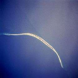
Island from Space Shuttle, April 1994. Oriented clockwise through 225 degrees, i.e., north is in the lower left corner. | |
| Coordinates: 43°57′0″N 59°54′57″W / 43.95000°N 59.91583°WCoordinates: 43°57′0″N 59°54′57″W / 43.95000°N 59.91583°W | |
| Country | Canada |
| Province | Nova Scotia |
| Municipality | Halifax Regional Municipality |
| District | 13 |
| Founded | 1521 |
| Area(Island) | |
| • Land | 34 km2 (13 sq mi) |
| Population (2008) | |
| • Total | 5 |
| • Density | 0.14/km2 (0.4/sq mi) |
| Time zone | AST (UTC-4) |
| • Summer (DST) | ADT (UTC-3) |
| GNBC Code | CBRQR |
Sable Island (French: île de Sable) is a small island situated 300 km (190 mi) southeast of Halifax, Nova Scotia, and about 175 km (109 mi) southeast of the closest point of mainland Nova Scotia in the Atlantic Ocean. It is a year-round home to approximately five people, with summer numbers swelled by tourists, scientists, and others. Notable for the Sable Island horse, the island is protected and managed by Parks Canada. Permission must first be granted by it before anyone may visit. Sable Island is part of District 7 of the Halifax Regional Municipality[1] in Nova Scotia. The island is also a protected National Park Reserve.
_p0187_SABLE_ISLAND.jpg)
History
Early history
The expedition of Portuguese explorer João Álvares Fagundes explored this region in 1520–1521 and were among the first Europeans to encounter the island. It is likely that he named the island "Fagunda" after himself.[2] An island called Fagunda appears on later Portuguese maps placed to the southeast of Cape Breton, fairly near its present location, however the identification of Sable Island with Fagunda is not certain.[3] On the other hand, 16th century Portuguese sources describe a fishing colony founded by the navigator in the Cape Breton Island,[4] further north. It is also possible that Fagundes sighted the island while heading southwest, reaching the Bay of Fundy, as the cartography and later Samuel de Champlain suggested, but this is unclear.[5] A brief attempt at French colonization at the end of the 16th century using convicts failed.[6][7] The island was inhabited sporadically by sealers, shipwreck survivors, and salvagers known as "wreckers."
The Nova Scotia Rescue Station
A life-saving station was established on Sable Island by the Governor of Nova Scotia, John Wentworth, in 1801. The rescue station began the continuous human presence on the island which continues today. Wentworth appointed James Morris, a Nova Scotian veteran of the British Royal Navy as the first superintendent of the island. Morris settled on the island in October 1801 with his family. By the time Morris died on the island in 1809, he had built up the humanitarian settlement to include a central station, two rescue boat stations, several lookout posts and survivor shelters.[8] The station's rescue equipment was upgraded in 1854 with the latest generation of self-bailing lifeboats and life cars through the fundraising efforts of social reformer Dorothea Dix who had visited the island in the previous year.[9]
Post Confederation
The Canadian government took over administration of the station with Confederation in 1867 and added two lighthouses in 1872, Sable Island East End Light on the eastern tip and Sable Island West End Light on the western end.[10] Until the advent of modern ship navigation, Sable Island was home to the families of the life-saving crews and the lighthouse keepers. In the early 20th century, the Marconi Company established a wireless station on the island and the Canadian government similarly established a weather station. Several generations of island staff were born and raised families of their own on the island, although a decline in shipwrecks gradually reduced the size of the lifesaving community. Only two people have been born on Sable Island since 1920.[11]
Decline of shipwrecks, rise of science
Improvements in navigation led to a dramatic drop in shipwrecks by the mid 20th century. The rescue station on Sable was reduced and eventually closed in 1958. The Canadian Coast Guard (CCG) first automated and eventually decommissioned the light stations. However, during this period, the island's role in science grew, first in weather research. The Canadian government expanded the collection of weather data originally started by the rescue station into a full meteorological station operated by Environment Canada and Department of Fisheries and Oceans. The station conducts routine atmospheric and meteorological studies from a permanently occupied station on Sable Island because of its unique isolated geographic position down-wind from the North American mainland. In addition to weather studies, research on the island expanded to a range of ecological and wildlife studies due to its unique position in the Atlantic.
Sable Island is specifically mentioned in the British North America Act 1867, Part 4, Section 91 as being the special responsibility of the federal government ("...the exclusive Legislative Authority of the Parliament of Canada extends to [...] 9. Beacons, Buoys, Lighthouses, and Sable Island."). For this reason it is considered a separate amateur radio "entity" (equivalent to a country for award credit), and with visiting operations using the special callsign prefix CY0.
Out of concern for preserving the island's frail ecology, all visitors to the island, including recreational boaters, require specific permission from Parks Canada. Sable Island's heliport contains emergency aviation fuel for search and rescue helicopters, which use the island to stage further offshore into the Atlantic. Should the need arise, the island serves as an emergency evacuation point for crews aboard nearby drilling rigs of the Sable Offshore Energy Project.
The Canadian Forces patrols the area using aircraft and naval vessels, partly due to the nearby presence of natural gas and oil drilling rigs and an undersea pipeline.
National Park
On October 17, 2011,[12] the Nova Scotia government entered into an agreement with the federal government to eventually protect the Island as a national park.[13] The news followed an announcement made by the federal government in May 2010, increasing the level of protection the island receives by transferring control from the Canadian Coast Guard to Parks Canada, which manages the island under the National Parks Act.[14]
Sable Island became a National Park Reserve on June 20, 2013 with approval of Mi'kmaq stakeholders. Full national park status has yet to be achieved, pending settlement of native land claims. The park is home to hundreds of species of flora and fauna including a breed of the unique Sable Island horse. The park is also a breeding ground for marine life.[15]
In July 2016, a hike across Sable Island was added to Google Streetview. Google worked with Parks Canada to add the interactive views of Sable and five other Canadian National Parks.[16] The imagery was collected in September 2015 by a Parks Canada employee who carried a backpack version of the Street View car camera around an area on the centre of the island, part of Google's Trekker program which explores off-road scenic locations. The route follows a hiking route that Parks Canada staff uses to escort adventure tourists who visit the island.[17]
Geography
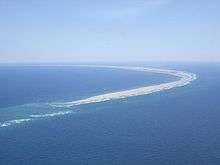
Sable Island is a narrow, crescent-shaped sandbar with a surface area of about 34 km2 (13 sq mi). Despite being nearly 42 km (26 mi) long, it is only 1.5 km (0.93 mi) across at its widest point. It emerges from vast shoals and shallows on the continental shelf, which, in tandem with the area's frequent fog and sudden strong storms including hurricanes and nor'easters, have caused over 350 recorded shipwrecks. It is often referred to as the Graveyard of the Atlantic,[18] as it sits astride the great circle route from North America's east coast to Europe. The nearest landfall is 160 kilometres (99 mi) to the northwest near Canso, Nova Scotia.
Sable Island is believed to have formed from a terminal moraine deposited on the continental shelf near the end of the last Ice Age.[19] It is both slowly moving as waves erode the western shore and new sand is added on the eastern shore and continually changing shape through the effects of strong winds and violent ocean storms.
The island has several freshwater ponds on the south side between the station and west light, however, in recent years their protecting dune-line has been eroded to such an extent that they are changing from one year to the next. In prior years, a brackish lake named Lake Wallace existed in the center of the south beach. At its largest, it extended for many miles; indeed, during World War II, amphibious aircraft landed on it. Over the years, the lake shrunk with an infilling of sand, until in late 2011, it filled in entirely and disappeared. Since the south beach is subject to flooding during fall storms, photos often show water in the area around the former location of Lake Wallace, however, this flooded area is relatively shallow (only a few feet at most) and is not a remnant of the lake. The original lake was of a significant enough depth that even during times when the area was flooded, the lake could be seen in aerial photographs as a darker (deeper) patch in the middle of the flooded area.
The island is a part of the Halifax Regional Municipality, the federal electoral district of Halifax, and the provincial electoral district of Halifax Citadel, although the urban area of Halifax proper is some 300 km (190 mi) away on the Nova Scotian mainland.
Climate
Sable Island's climate can be classified as oceanic (Köppen Cfb). Its climate is strongly influenced by the sea.[20] As such, winter temperatures average near freezing while during the summer months, temperatures average around 20 °C (68.0 °F).[20] The average annual temperature range in Sable Island is only 18.6 °C (33.5 °F) owing to the influence from the sea compared to 24.3 °C (43.7 °F) at Halifax and 38.9 °C (70.0 °F) in Winnipeg.[20] Generally, February is the coldest month while August is the warmest month.[20] Sable Island averages 1,372 millimetres (54.0 in) of precipitation a year, which is fairly evenly distributed throughout the year.[20] Being located in the path of major frontal storms and tropical cyclones year-round, most of the precipitation comes from these storms.[20] Thunderstorms are rare, with only 11 days with thunderstorms per year.[20] There are frequent heavy fogs in the area due to the contrasting effects of the cold Labrador Current and the warm Gulf Stream: on average there are 127 days out of the year that have at least 1 hour of fog.[20] This makes Sable Island the foggiest place in the Maritimes.[20] The foggiest season is during the summer months where July averages 22 fog days.[20] During the winter, Sable Island has the warmest temperatures in Canada apart from the Pacific coast, and can have the warmest temperatures in the country on some occasions due to the influence of the Gulf Stream. Summers are among the coolest in southern Canada though. It is also the most hurricane-prone part of Canada, also due to the Gulf Stream, and is the only place where Category 3 hurricane-force winds are likely in all of Canada. The highest temperature recorded was 27.8 °C (82.0 °F) on August 27, 1951 while the lowest temperature recorded was −19.4 °C (−2.9 °F) on January 31, 1920.[20]
| Climate data for Sable Island (1981−2010) | |||||||||||||
|---|---|---|---|---|---|---|---|---|---|---|---|---|---|
| Month | Jan | Feb | Mar | Apr | May | Jun | Jul | Aug | Sep | Oct | Nov | Dec | Year |
| Record high humidex | 15.2 | 12.5 | 13.7 | 15.0 | 20.0 | 28.1 | 32.8 | 35.3 | 34.2 | 30.7 | 22.3 | 17.2 | 35.3 |
| Record high °C (°F) | 14.5 (58.1) |
12.8 (55) |
13.7 (56.7) |
13.9 (57) |
17.8 (64) |
21.7 (71.1) |
26.7 (80.1) |
27.8 (82) |
27.0 (80.6) |
22.8 (73) |
18.9 (66) |
15.6 (60.1) |
27.8 (82) |
| Average high °C (°F) | 3.0 (37.4) |
1.8 (35.2) |
3.3 (37.9) |
6.5 (43.7) |
10.2 (50.4) |
14.2 (57.6) |
18.5 (65.3) |
20.7 (69.3) |
18.6 (65.5) |
14.3 (57.7) |
9.9 (49.8) |
5.5 (41.9) |
10.6 (51.1) |
| Daily mean °C (°F) | −0.1 (31.8) |
−1.2 (29.8) |
0.7 (33.3) |
4.0 (39.2) |
7.5 (45.5) |
11.4 (52.5) |
15.8 (60.4) |
17.9 (64.2) |
15.8 (60.4) |
11.7 (53.1) |
7.3 (45.1) |
2.5 (36.5) |
7.8 (46) |
| Average low °C (°F) | −3.1 (26.4) |
−4.2 (24.4) |
−2.0 (28.4) |
1.5 (34.7) |
4.8 (40.6) |
8.6 (47.5) |
13.0 (55.4) |
15.1 (59.2) |
13.0 (55.4) |
9.1 (48.4) |
4.6 (40.3) |
−0.5 (31.1) |
5.0 (41) |
| Record low °C (°F) | −19.4 (−2.9) |
−18.3 (−0.9) |
−13.6 (7.5) |
−8.9 (16) |
−8.3 (17.1) |
0.6 (33.1) |
3.0 (37.4) |
4.4 (39.9) |
0.6 (33.1) |
−1.2 (29.8) |
−7.8 (18) |
−16.7 (1.9) |
−19.4 (−2.9) |
| Record low wind chill | −29.6 | −33.0 | −24.6 | −20.4 | −8.7 | 0.0 | 0.0 | 0.0 | 0.0 | −3.1 | −13.8 | −25.7 | −33.0 |
| Average precipitation mm (inches) | 144.7 (5.697) |
112.5 (4.429) |
130.4 (5.134) |
114.8 (4.52) |
101.3 (3.988) |
115.9 (4.563) |
100.8 (3.969) |
121.6 (4.787) |
129.5 (5.098) |
144.9 (5.705) |
150.7 (5.933) |
144.5 (5.689) |
1,511.6 (59.512) |
| Average rainfall mm (inches) | 110.4 (4.346) |
92.4 (3.638) |
107.7 (4.24) |
105.9 (4.169) |
101.2 (3.984) |
115.9 (4.563) |
100.8 (3.969) |
121.6 (4.787) |
129.5 (5.098) |
144.8 (5.701) |
145.1 (5.713) |
123.7 (4.87) |
1,399 (55.079) |
| Average snowfall cm (inches) | 33.3 (13.11) |
19.8 (7.8) |
22.1 (8.7) |
9.1 (3.58) |
0.11 (0.043) |
0.0 (0) |
0.0 (0) |
0.0 (0) |
0.0 (0) |
0.01 (0.004) |
5.2 (2.05) |
18.6 (7.32) |
108.3 (42.64) |
| Average precipitation days (≥ 0.2 mm) | 20.4 | 16.8 | 16.7 | 16.0 | 14.5 | 13.9 | 13.5 | 12.0 | 12.4 | 16.2 | 19.3 | 19.8 | 191.5 |
| Average rainy days (≥ 0.2 mm) | 12.1 | 9.9 | 12.5 | 15.1 | 15.3 | 13.8 | 13.3 | 12.4 | 13.0 | 16.2 | 18.7 | 15.6 | 167.8 |
| Average snowy days (≥ 0.2 cm) | 11.6 | 10.0 | 7.2 | 2.6 | 0.19 | 0.0 | 0.0 | 0.0 | 0.0 | 0.06 | 2.8 | 8.6 | 43.0 |
| Mean monthly sunshine hours | 61.0 | 78.6 | 119.0 | 140.0 | 169.4 | 186.6 | 192.3 | 194.3 | 174.1 | 138.3 | 80.2 | 61.8 | 1,595.5 |
| Percent possible sunshine | 21.2 | 26.6 | 32.2 | 34.8 | 37.1 | 40.4 | 41.1 | 44.8 | 46.3 | 40.4 | 27.6 | 22.2 | 34.6 |
| Source: Environment Canada[21] | |||||||||||||
According to PlantMaps, Sable Island lies in Hardiness Zone 8a (10°F–15°F) for plant hardiness.[22]
Vegetation and wildlife
Sable Island derived its name from the French word for "sand".[23] It lacks natural trees, being covered instead with marram grass and other low-growing vegetation. In 1901, the federal government planted over 80,000 trees in an attempt to stabilize the soil; all died. Subsequent plantings resulted in the survival of a single Scots pine. Although planted in the 1960s, it is only a few feet tall.
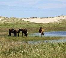
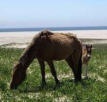
The island is home to over 400 free-roaming horses, protected by law from human interference. This feral horse population is likely descended from horses confiscated from Acadians during the Great Expulsion and left on the island by Thomas Hancock, Boston merchant and uncle of John Hancock.[24] In 1879, 500 horses and cattle were estimated to live on the island, and the island vegetation was described as covered with grass and wild peas.[25] In the past, excess horses were rounded up, shipped off the island, and sold, many used in coal mines on Cape Breton Island, Nova Scotia. In 1960 the Canadian Government gave the horse population full protection from human interference.
Harbour and grey seals breed on the island's shores. Seal counts from the 1960s for the grey seal population estimated 200–300 pups born at that time on the island, but surveys from as recent as 2003–2004 estimated the number of pups born in that season at 50,000.[26] The seals are occasionally preyed upon by the various shark species that inhabit the waters nearby. Unusual 'corkscrew' bite wounds on dead seals suggest that the Greenland shark is probably responsible for most attacks here.[27]
Several large bird colonies are resident, including the Arctic tern and Ipswich sparrow, a subspecies of the Savannah sparrow which breeds only on the island. Many other species are resident, migratory, or transient, blown out to sea in storms and returned to land out of their natural range.
It was formerly believed the freshwater sponge Heteromeyenia macouni was found only in ponds on the island. However, it is now considered to be the same species as Racekiela ryderi, found elsewhere.[28]
Shipwrecks
Sable Island is famous for its large number of shipwrecks. An estimated 350 vessels are believed to have fallen victim to the island's sand bars. Thick fogs, treacherous currents, and the island's location in the middle of a major transatlantic shipping route and rich fishing grounds account for the large number of wrecks. The first recorded wreck was the English ship Delight in 1583, part of Humphrey Gilbert's Newfoundland expedition.[29] It is likely that the construction of lighthouses on each end of the island in 1873 contributed to the decrease in shipwrecks. The last major shipwreck was the steamship Manhasset in 1947. Her crew were all saved, the last significant rescue of the Sable lifesaving station.[30] No further wrecks occurred until 1999 when the three crew members of the yacht Merrimac survived after their sloop ran aground due to a navigational error.[31] Few of the wrecks surrounding the island are visible, as they are usually crushed and buried by the sand.[32]
After the 1991 Perfect Storm, the commercial fishing vessel Andrea Gail's emergency position-indicating radio beacon (EPIRB) was discovered on the shore of Sable Island on November 6, 1991, nine days after the last transmission from the crew. Other items found were fuel drums, a fuel tank, an empty life raft, and some other flotsam. All crew members perished and were never found.
Sable Island Station
| Sable Island | |||||||||||
|---|---|---|---|---|---|---|---|---|---|---|---|
| IATA: none – ICAO: none – TC LID: CSB2 | |||||||||||
| Summary | |||||||||||
| Airport type | Private | ||||||||||
| Owner | Parks Canada | ||||||||||
| Operator | Parks Canada | ||||||||||
| Location | Sable Island, Nova Scotia | ||||||||||
| Time zone | AST (UTC−04:00) | ||||||||||
| • Summer (DST) | ADT (UTC−03:00) | ||||||||||
| Elevation AMSL | 4 ft / 1 m | ||||||||||
| Coordinates | 43°55′46″N 059°57′35″W / 43.92944°N 59.95972°W | ||||||||||
| Map | |||||||||||
 CSB2 Location in Canada | |||||||||||
| Helipads | |||||||||||
| |||||||||||
|
Source: Canada Flight Supplement[33] | |||||||||||
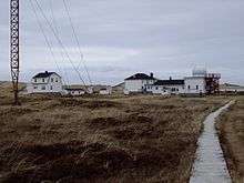
The Sable Island Station, managed and staffed by Parks Canada and Environment Canada, is the only permanently staffed facility on the island. Climatological record-keeping on Sable Island began in 1871 with the establishment of the Meteorological Service of Canada, and has been continuous since 1891.
Sable Island is the subject of extensive scientific research. A wide range of manual and automated instruments are used at the Station, including the Automated Weather Observing System operated by the Meteorological Service of Canada, an aerology program measuring conditions in the upper atmosphere using a radiosonde carried aloft by a hydrogen-filled weather balloon to altitudes beyond 40 km (25 mi), and a program collecting data on background levels of carbon dioxide, which began there in 1974. Research is done to monitor the long-range transport of pollution aerosols. Fog chemistry is studied, examining the transport and composition of atmospheric toxins it carries. Tropospheric ozone is measured and analyzed by researchers in Canada and the United States along with 20 other North American sites.
The installation of the BGS Magnetic Observatory on Sable Island was funded as a joint venture between the British Geological Survey, Sperry-Sun Drilling Services, and Sable Offshore Energy. The data it collects aid scientific research into rates of change of the Earth's magnetic field and increase the accuracy of the BGS Global Geomagnetic Model. Data from the geomagnetic observatory is used by the offshore energy industry for precise positioning activities such as directional drilling.
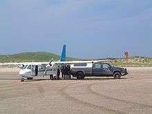
Supplies are delivered to the Sable Island Station approximately twice a month by Sable Aviation using a Britten-Norman Islander. Although the island has a heliport (CST5), there is no permanent runway for fixed wing aircraft, which land instead on south beach in an area designated as the Sable Island Aerodrome (CSB2).[33] Prior permission is required to land, as the area is often unusable due to changing sand conditions.
Sable Island in popular culture
The unique landscape, history of shipwrecks, and wildlife, especially horses, have made Sable Island an iconic place in Atlantic Canada and attracted considerable international following.
In non-fiction
Shipwreck survivors published early survival narratives about their experiences at Sable Island, beginning with the sinking of the Delight in 1583.[34] The first formal history of the island, Sable Island: its History and Phenomena, was written in 1894 by George Patterson. Many other histories of the island and its shipwrecks have been published since, such as Lyall Campbell's two books - Sable Island, Fatal and Fertile Crescent in 1974 and Sable Island Shipwrecks: Disaster and Survival at the North Atlantic Graveyard in 1994 - and more recently, A Dune Adrift: The Strange Origins and Curious History of Sable Island, written in 2004 by Marq de Villiers. In his best-selling 1997 book, The Perfect Storm, Sebastian Junger briefly describes the geography and history of the island.[35]
In fiction
The island has also inspired works of fiction beginning in 1802 when Nova Scotia author Thomas Chandler Haliburton published "The Sable Island Ghost", a story about a ghostly woman inspired by the loss of the brig Francis in 1798. His story helped raise support for the establishment of a rescue station on the island.[36] Canadian writer James MacDonald Oxley wrote a youth novel The Wreckers of Sable Island in 1897. Frank Parker Day's 1928 novel Rockbound features a vivid depiction of the sinking of the schooner Sylvia Mosher during the 1926 August Gales at Sable Island.[37] One of the island's most notable temporary residents was Nova Scotian author Thomas H. Raddall, whose early experiences working at the wireless post there served as the inspiration for his 1950 novel The Nymph and the Lamp.[38] In his novel The Templar Throne published in June 2010, author Paul Christopher mentions the Island as the final location of the True Ark, a coveted Christian religious relic.[39]
In photography
The dunes and horses of Sable Island have drawn many photographers. Among the first was Arthur Williams McCurdy who photographed the island, its horses and shipwrecks in 1898 for National Geographic during a visit with Alexander Graham Bell.[40] In more recent times, Roberto Dutesco, a fashion photographer, began taking photos of Sable horses in 1994 and features this work in a permanent photo exhibition entitled "Wild Horses of Sable Island" at his gallery in New York. Nova Scotian photographer Paul Illsley's photographs of Sable Island horses inspired both a Canadian stamp and coin in 2005.
In music
In 1970 Stompin' Tom Connors published his song "Sable Island" in 1970's Stompin' Tom Meets Big Joe Mufferaw. Canadian folk singer Catherine McKinnon recorded a song arranged by Don Gillis also entitled "Sable Island" for the Canadian Broadcasting Corporation in 1975. The first line of the Buck 65 song "Blood of a young wolf" is "Ten thousand horses, Sable Island, endless summer".
In documentaries
The island has been the subject of many Canadian documentaries by the Canadian Broadcasting Corporation and the National Film Board of Canada, beginning with the 1956 NFB film Sable Island by Allan Wargon, the 2003 NFB documentary Moving Sands by Phillipe Baylaucq,[41] and more recently, an episode of Land and Sea.[42] The most recent works about Sable Island is the Canadian produced film, "S(t)able Island: The Beauty of the Free", created by Rae-Anne LaPlante. The film explores in-depth the wild horse population that has called Sable Island its home for over 250 years. [43] A number of international documentaries have also explored the island including the 2007 film "Ile de sable" made by Jean-Francois Ducrocq and Malek Sahraoui for France 3, French public television.[44] In 2007, Matt Trecartin of Halifax directed Chasing Wild Horses, a documentary about photographer Roberto Dutesco and his photography of the Sable Island horses.[45]
In other films
In the 1937 film Captains Courageous, the fishing boat passes Sable Island on the way to the Grand Banks of Newfoundland. Spencer Tracy's character Manuel later says his father died off Cape Sable. Sable Island is briefly featured in the 2000 feature film The Perfect Storm, which depicts the sinking of the fishing vessel Andrea Gail near Sable, although the island is erroneously portrayed with trees and a giant stone lighthouse. Sable Island is the setting for the 2002 film Touching Wild Horses starring Jane Seymour; however, little attempt was made to mimic the natural landscape of Sable, with trees and rocks abounding in the background of most every scene, Sandbanks Provincial Park in Ontario standing in for the island in the film.[46]
In exhibits
A permanent exhibit about Sable Island is featured at the Maritime Museum of the Atlantic in Halifax, which includes two rescue boats from Sable and numerous name boards and figureheads from Sable Island wrecks. A small exhibit about the Sable Island horses is found at the Nova Scotia Museum of Natural History. The horses were featured in a 1994 exhibit at the Equine Museum of Japan in Yokohama.[47]
On radio
On September 11, 2014 Don Connolly of CBC Radio's Information Morning broadcast part of the daily current affairs program from Sable Island. It was the first ever live commercial radio broadcast from the island.[48] (Amateur radio operators have been transmitting from Sable Island for decades.)
See also
References
- ↑ "Search Results: Sable island". gsa1.gov.ns.ca. Retrieved 2014-10-06.
- ↑ "A Brief History of Sable Island". Sableislandfriends.ca. 2012-09-04. Retrieved 2014-01-02.
- ↑ "FAGUNDES, JOÃO ALVARES". Dictionary of Canadian Biography
- ↑ Tratado das ilhas novas e descombrimento dellas e outras couzas, 1570 Francisco de Souza, Page 6
- ↑ Mount Allison University, Marshlands: Records of Life on the Tantramar: European Contact and Mapping, 2004
- ↑ "Canadian Military Heritage". Cmhg.gc.ca. 2011-11-03. Retrieved 2014-02-19.
- ↑ Roger E. Riendeau (2007). A Brief History of Canada. Infobase Publishing. p. 36. ISBN 978-1-4381-0822-3.
- ↑ ""James Morris", ''Dictionary of Canadian Biography''". Biographi.ca. Retrieved 2014-01-02.
- ↑ "Thomas E. Appleton, "Dorothea Dix", ''USQUE AD MARE A History of the Canadian Coast Guard and Marine Services''". Ccg-gcc.gc.ca. 2013-06-24. Retrieved 2014-01-02.
- ↑ E.H. Rip Irwin. Lighthouses and Lights of Nova Scotia, Nimbus Press, pages 100-102
- ↑ Greg McNeil Published on October 30, 2008 (2008-10-30). "Sable Island Native Returns Home Cape Breton Post (30 Oct 2008)". Capebretonpost.com. Retrieved 2014-01-02.
- ↑ "Sable Island named national park". Cbc.ca. 2011-10-17. Retrieved 2014-01-02.
- ↑ Siri Agrell. "The 'Graveyard of the Atlantic' – reborn". Theglobeandmail.com. Retrieved 2014-01-02.
- ↑ Ross, Selena (2012-04-01). "Parks Canada Takes Control of Sable Island Today (The Chronicle Herald, April 1, 2012)". Thechronicleherald.ca. Retrieved 2014-01-02.
- ↑ "MP defends decision to vote for Sable Island national park". Cbc.ca. 2013-06-19. Retrieved 2014-01-02.
- ↑ Anjuli Patil, "Sable Island now on Google Street View", CBC News July 13, 2016
- ↑ Parker Donham "Google Street View comes to Sable Island", The Contrarian, July 13, 2016
- ↑ ""Sable Island: Graveyard of the Atlantic", ''Mysteries of Canada''". Mysteriesofcanada.com. Retrieved 2014-01-02.
- ↑ Sheridan, Kate (June 8, 2015). "The Curious Case of Sable Island". Hakai Magazine. Retrieved 8 June 2015.
- 1 2 3 4 5 6 7 8 9 10 11 "The Climate of Sable Island". The Climates of Canada. Environment Canada. Archived from the original on February 18, 2010. Retrieved 17 May 2015.
- ↑ "Sable Island". Canadian Climate Normals 1981–2010. Environment Canada. Retrieved 2013-09-22.
- ↑ "Nova Scotia Interactive Plant Hardiness Zone Map". PlantMaps. Retrieved 2016-09-14.
- ↑ Upham, Warren (1920). Minnesota Geographic Names: Their Origin and Historic Significance. Minnesota Historical Society. p. 44.
- ↑ ""Free as the Wind: How the Horses Came to Sable Island", ''Sable Island: A story of Survival'' website Nova Scotia Museum". Epe.lac-bac.gc.ca. Retrieved 2014-01-02.
- ↑ "Miscellaneous". The Cornishman (56). 7 August 1879. p. 6.
- ↑ Sable Island: Photographic Survey of Grey Seal Pups (Feb 2004)
- ↑ Shark Predation on Sable Island Seals (July 2008)
- ↑ van Soest, R. (2014). R. W. M. Van Soest, N. Boury-Esnault, J. N. A. Hooper, K. Rützler, N. J. de Voogd, B. Alvarez de Glasby, E. Hajdu, A. B. Pisera, R. Manconi, C. Schoenberg, D. Janussen, K. R. Tabachnick, M. Klautau, B. Picton, M. Kelly & J. Vacelet, eds. "Heteromeyenia macouni MacKay, 1900". World Porifera database. World Register of Marine Species. Retrieved 2014-05-22.
- ↑ ""Delight-1583", Nova Scotia Museum On the Rocks Marine Heritage Database". Museum.gov.ns.ca. Retrieved 2014-01-02.
- ↑ ""Manhasset-1947", Nova Scotia Museum On the Rocks Marine Heritage Database". Museum.gov.ns.ca. Retrieved 2014-01-02.
- ↑ "Maritime Museum of the Atlantic Sable Island Shipwreck & Lifesaving Web Page". Maritimemuseum.novascotia.ca. 1999-07-27. Retrieved 2014-01-02.
- ↑ ""Sable Island Graveyard of the Atlantic" Digital Collection, Industry Canada". Epe.lac-bac.gc.ca. Retrieved 2014-01-02.
- 1 2 Canada Flight Supplement. Effective 0901Z 15 September 2016 to 0901Z 10 November 2016
- ↑ Rainer K. Baehre “The Casting Away of the Delight” in Outrageous Seas: Shipwreck and Survival in the Waters off Newfoundland, 1583–1893 McGill-Queens Press (1999), p. 12
- ↑ Sebastian Junger The Perfect Storm: A True Story of Men Against the Sea, Norton (1997), pp. 133-135
- ↑ Gail Anne McNeil, "Sable Island, the Graveyard of the Atlantic", in Disasters at Sea, Tony Cranston (1986), p. 119.
- ↑ Gwendolyn Davies, "Afterword", Rockbound, University of Toronto Press (1989), p. 302
- ↑ Heath, Jeffrey M. (1 September 1991). Profiles in Canadian Literature. 7. Dundurn. p. 82. ISBN 978-1-55002-145-5.
- ↑ Christopher, P. (2010). The Templar Throne. Penguin Group US. ISBN 9781101198018. Retrieved 2014-10-06.
- ↑ "McCurdy, Arthur Williams ''Canadian Dictionary of Biography''". Biographi.ca. Retrieved 2014-01-02.
- ↑ ""Moving Sands" ''CM Magazine'' Manitoba Library Association, (Feb. 4, 2005) Vol. XI, No. 11". Umanitoba.ca. 2005-02-04. Retrieved 2014-01-02.
- ↑ "Land and Sea - Sable Island". Cbc.ca. Retrieved 2014-01-02.
- ↑ (http://stableisland.com/)
- ↑ "Ile de sable" (2007) bonne compagnie
- ↑ "Chasing Wild Horses documents photographer's obsession". Cbc.ca. 2008-09-17. Retrieved 2014-01-02.
- ↑ IMDB
- ↑ "Sable Island Horses", Green Horse Society
- ↑ "Sable Island: CBC makes history, broadcasting live from island: Information Morning broadcast live from Sable Island" (CBC News). CBC. 11 September 2014. Retrieved 2014-09-16.
Bibliography
- A Dune Adrift: The Strange Origins and Curious History of Sable Island, by Marq de Villiers and Sheila Hirtle, ISBN 0-7710-2642-0, McClelland & Stewart, August 2004
- Ethos of Voice in the Journal of James Rainstorpe Morris from the Sable Island Humane Station, 1801–1802, by Rosalee Stilwell, ISBN 0-7734-7663-6, Edwin Mellen Press, January 2001
- Free as the Wind: Saving the Horses of Sable Island, text by Jamie Bastedo, illustrations by Susan Tooke, Red Deer Press, 2007
- Sable Island, by Bruce Armstrong, ISBN 0-385-13113-5, Doubleday, July 1981
- Sable Island Journals 1801–1804, by James Rainstorpe Morris, ISBN 0-9689245-0-6
- Sable Island Shipwrecks: Disaster and Survival at the North Atlantic Graveyard by Lyall Campbell, Nimbus pub., ISBN 1-55109-096-1, December 2001
- Wild and Beautiful Sable Island, Pat Keough et al., ISBN 0-9692557-3-X, Green Publishing, September 1993
- Wild Horses of Sable Island, by Zoe Lucas, ISBN 0-919872-73-5, Firefly Books Ltd., August 1992
External links
| Wikimedia Commons has media related to Sable Island. |
| Wikisource has the text of The New Student's Reference Work article Sable Island. |
| Wikisource has the text of the 1911 Encyclopædia Britannica article Sable Island. |
- Sable Island Green Horse Society
- Aircraft Charter to Sable Island
- Sable Island - Satellite View - Google Maps
- Maritime Museum of the Atlantic, Halifax Sable Island Shipwreck Page
- Tales of Tragedy and Triumph: Canadian Shipwrecks, a virtual museum exhibition at Library and Archives Canada
- Friends of Sable Island Society (formerly Sable Island Preservation Trust)
- Ships of War lost on the Coast of Nova Scotia and Sable Island, during the Eighteenth Century (Note: the Major Elliott of the 43rd Regiment of Foot survived a 1760 shipwreck - see below)
- Major Robert Elliott - A Sable Island Shipwreck survivor
- Nova Scotia Museum of Natural History: Sable Island - An Island of Sand
- The Wild Horses of Sable Island Gallery (photos by Roberto Dutesco)
- Wild Horses of Sable Island Mobile Museum
- List of shipwrecks by year
