Saguenay River
| Saguenay River (Rivière Saguenay) | |
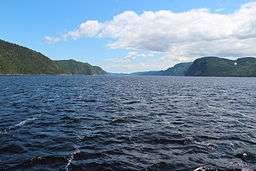 Saguenay River, inside the Saguenay–St. Lawrence Marine Park | |
| Country | Canada |
|---|---|
| Province | Quebec |
| Region | Saguenay–Lac-Saint-Jean |
| Source | Lac Saint-Jean |
| - location | Alma, Saguenay–Lac-Saint-Jean |
| - coordinates | 48°32′28″N 71°36′54″W / 48.54111°N 71.61500°W |
| Mouth | Saint Lawrence River |
| - location | Tadoussac / Baie-Sainte-Catherine, Côte-Nord / Capitale-Nationale |
| - coordinates | 48°07′45″N 69°42′13″W / 48.12917°N 69.70361°WCoordinates: 48°07′45″N 69°42′13″W / 48.12917°N 69.70361°W |
| Length | 160 km (100 mi) |
| Basin | 88,000 km2 (34,000 sq mi) [1] |
| Discharge | for Saint Lawrence River |
| - average | 1,750 m3/s (61,800 cu ft/s) [1] |
 | |
The Saguenay River (French: Rivière Saguenay) is a major river of Quebec, Canada. It drains Lac Saint-Jean in the Laurentian Highlands, leaving at Alma and running east; the city of Saguenay is located on the river. It drains into the Saint Lawrence River. Tadoussac, founded as a French colonial trading post in 1600, is located on the northwest bank at this site.
The river has a very high flow-rate and is bordered by steep cliffs associated with the Saguenay Graben. Tide waters flow in its fjord upriver as far as Chicoutimi (about 100 kilometres). Many Beluga whales breed in the cold waters at its mouth, making Tadoussac a popular site for whale watching and sea kayaking; Greenland sharks also frequent the depths of the river. The area of the confluence of the Saguenay and Saint Lawrence is protected by the Saguenay–St. Lawrence Marine Park, one of Canada's national parks.
The Saguenay River was used as an important trade route into the interior for the First Nations people of the area. During the French colonization of the Americas, the river became a major route for the fur trade. The French established Tadoussac, France's first trading post in Canada, in 1600. They named the river for the legendary Kingdom of Saguenay. It is the namesake of Saguenay Herald at the Canadian Heraldic Authority.
Beginning in the 19th century, the river was exploited for transport and power by the logging and pulp and paper industries. It generates hydroelectricity both for commercial power and to operate an aluminum smelter at Arvida.
Severe flooding of the Saguenay's tributary rivers from July 18 to 21, 1996, devastated the region in one of Canada's costliest natural disasters, the Saguenay Flood.[2] However, an unexpected effect of the flood was to cover the heavily contaminated sediments at the bottom of the river with 10 to 50 centimetres (3.9 to 19.7 in) of new, relatively clean sediments. Research has shown that the old sediments are no longer a threat to ecosystems.[3]
Tributaries
The significant tributaries of the Saguenay are (in upstream order):
- Sainte-Marguerite River
- North-East Sainte-Marguerite River
- Saint-Jean River
- Ha! Ha! River
- Mars River
- Valin River
- Rivière du Moulin
- Chicoutimi River
- Shipshaw River
- Rivière aux Sables
- Rivière aux Écorces
- Lake Saint-Jean
- Peribonka River
- Mistassini River
- Ashuapmushuan River
- Ouiatchouaniche River
- Métabetchouane River
See also
Notes
- 1 2 Natural Resources Canada, Atlas of Canada - Rivers
- ↑ The Saguenay Flood
- ↑ Project Saguenay
External links
![]() Media related to Saguenay River at Wikimedia Commons
Media related to Saguenay River at Wikimedia Commons