Sai Noi District
| Sai Noi ไทรน้อย | |
|---|---|
| Amphoe | |
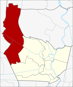 Amphoe location in Nonthaburi Province | |
| Coordinates: 13°58′44″N 100°18′49″E / 13.97889°N 100.31361°ECoordinates: 13°58′44″N 100°18′49″E / 13.97889°N 100.31361°E | |
| Country |
|
| Province | Nonthaburi |
| Seat | Khlong Khwang |
| Tambon | 7 |
| Muban | 68 |
| Amphoe established | January 1, 1948 |
| Area | |
| • Total | 186.017 km2 (71.822 sq mi) |
| Population (2015) | |
| • Total | 62,573 |
| • Density | 336.38/km2 (871.2/sq mi) |
| Time zone | THA (UTC+7) |
| Postal code | 11150 |
| Geocode | 1205 |
Sai Noi (Thai: ไทรน้อย, pronounced [sāj nɔ́ːj]) is the northwesternmost district (amphoe) of Nonthaburi province, central Thailand.
Geography
Neighboring districts are (from the north clockwise) Lat Bua Luang (Ayutthaya Province) Lat Lum Kaeo (Pathum Thani Province), Bang Bua Thong, Bang Yai, and the districts Phutthamonthon and Bang Len of Nakhon Pathom Province.
History
At first the area was administrated from Amphoe Bang Bua Thong. On January 1, 1948 four subdistricts were split off to from the new minor district (king amphoe) Sai Noi.[1] On June 6, 1956 it was elevated to full district status.[2]
In 1959 the Tambon Khun Si was transferred from Amphoe Bang Len (Nakhon Pathom) to become part of Sai Noi.[3]
In 1979 the southern part of Tambon Rat Niyom formed the new Tambon Khlong Khwang.[4] The following year the southern part of Tambon Sai Noi was split off to create Tambon Thawi Watthana.[5]
Administration
The district is subdivided into 7 subdistricts (tambon), which are further subdivided into 68 villages (muban). Sai Noi itself has subdistrict municipality status (thesaban tambon) which covers parts of tambon Sai Noi and Khlong Khwang. There are further 7 Tambon administrative organizations (TAO).
| No. | Name | Thai | Villages | Inh. |
|---|---|---|---|---|
| 1. | Sai Noi | ไทรน้อย | 11 | 19,088 |
| 2. | Rat Niyom | ราษฎร์นิยม | 8 | 6,223 |
| 3. | Nong Phrao Ngai | หนองเพรางาย | 12 | 6,664 |
| 4. | Sai Yai | ไทรใหญ่ | 11 | 6,260 |
| 5. | Khun Si | ขุนศรี | 8 | 4,740 |
| 6. | Khlong Khwang | คลองขวาง | 10 | 5,413 |
| 7. | Thawi Watthana | ทวีวัฒนา | 8 | 6,612 |
References
- ↑ ประกาศกระทรวงมหาดไทย เรื่อง ยกฐานะตำบลขึ้นเป็นกิ่งอำเภอ (PDF). Royal Gazette (in Thai). 64 (60 ง): 3188–3193. 1947-12-09.
- ↑ พระราชกฤษฎีกาจัดตั้งอำเภอนาทวี อำเภอสะบ้าย้อย อำเภอคำชะอี อำเภอย่านตาขาว อำเภอวัดโบสถ์ อำเภอหนองบัว อำเภอวัฒนานคร อำเภอแสวงหา อำเภอท่าชนะ อำเภอพระพุทธบาท อำเภอโนนสัง อำเภอบำเหน็จณรงค์ อำเภอคอนสวรรค์ อำเภอบ้านโฮ่ง อำเภอคีรีมาศ อำเภอชนแดน อำเภอแม่แจ่ม อำเภอไทรน้อย และอำเภอบ้านแพง พ.ศ. ๒๔๙๙ (PDF). Royal Gazette (in Thai). 73 (46 ก): 657. 1956-06-05.
- ↑ พระราชบัญญัติเปลี่ยนแปลงเขตจังหวัดนครปฐมและจังหวัดนนทบุรี พ.ศ. ๒๕๐๒ (PDF). Royal Gazette (in Thai). 76 (49 ก ฉบับพิเศษ): 1–3. 1959-05-01.
- ↑ ประกาศกระทรวงมหาดไทย เรื่อง ตั้งและเปลี่ยนแปลงเขตตำบลในท้องที่อำเภอไทรน้อย จังหวัดนนทบุรี (PDF). Royal Gazette (in Thai). 96 (135 ง ฉบับพิเศษ): 11–14. 1979-08-08.
- ↑ ประกาศกระทรวงมหาดไทย เรื่อง ตั้งและเปลี่ยนแปลงเขตตำบลในท้องที่อำเภอไทรน้อย จังหวัดนนทบุรี (PDF). Royal Gazette (in Thai). 97 (104 ง): 2166–2169. 1980-07-08.
External links
- amphoe.com (Thai)
Nonthaburi | ||
|---|---|---|
| Main article |  | |
| Capital | ||
| Districts (amphoe) | ||
| Related topics | ||
| Neighboring areas | ||