Saint-Évariste-de-Forsyth, Quebec
| Saint-Évariste-de-Forsyth | |
|---|---|
| Municipality | |
|
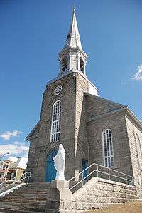
Roman Catholic Church serving the parish of Saint-Évariste. | |
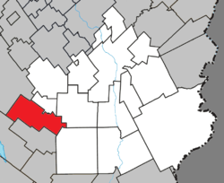 Location within Beauce-Sartigan RCM. | |
 Saint-Évariste-de-Forsyth Location in southern Quebec. | |
| Coordinates: 45°56′N 70°57′W / 45.933°N 70.950°WCoordinates: 45°56′N 70°57′W / 45.933°N 70.950°W[1] | |
| Country |
|
| Province |
|
| Region | Chaudière-Appalaches |
| RCM | Beauce-Sartigan |
| Constituted | March 1, 1870 |
| Government[2] | |
| • Mayor | Gaétan Bégin |
| • Federal riding | Beauce |
| • Prov. riding | Beauce-Sud |
| Area[2][3] | |
| • Total | 112.00 km2 (43.24 sq mi) |
| • Land | 111.22 km2 (42.94 sq mi) |
| Population (2011)[3] | |
| • Total | 525 |
| • Density | 4.7/km2 (12/sq mi) |
| • Pop 2006-2011 |
|
| • Dwellings | 310 |
| Time zone | EST (UTC−5) |
| • Summer (DST) | EDT (UTC−4) |
| Postal code(s) | G0M 1S0 |
| Area code(s) | 418 and 581 |
| Highways |
|
| Website |
www |
Saint-Évariste-de-Forsyth is a municipality in the Municipalité régionale de comté de Beauce-Sartigan in Quebec, Canada. It is part of the Chaudière-Appalaches region and the population is 647 at the 2006 census.
As with several other municipalities located in the Eastern Townships, Saint-Évariste-de-Forsyth derives its name from its Roman Catholic parish and its township. The parish is named after Pope Evaristus and the township after lumber baron James Bell Forsyth.
References
 |
Adstock | La Guadeloupe | | |
| |
Saint-Honoré-de-Shenley | |||
| ||||
| | ||||
| Lambton | Courcelles | Saint-Hilaire-de-Dorset |
| Cities & Towns | |
|---|---|
| Municipalities | |
| Parishes | |
| Villages | |
| |
This article is issued from Wikipedia - version of the 10/13/2015. The text is available under the Creative Commons Attribution/Share Alike but additional terms may apply for the media files.