Saint-Clément, Quebec
| Saint-Clément | |
|---|---|
| Parish municipality | |
 | |
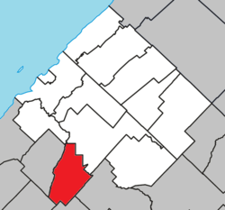 Location within Les Basques RCM | |
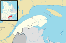 Saint-Clément Location in eastern Quebec | |
| Coordinates: 47°55′N 69°06′W / 47.92°N 69.1°WCoordinates: 47°55′N 69°06′W / 47.92°N 69.1°W[1] | |
| Country |
|
| Province |
|
| Region | Bas-Saint-Laurent |
| RCM | Les Basques |
| Constituted | January 1, 1885 |
| Government[2] | |
| • Mayor | Eric Blanchard |
| • Federal riding |
Rimouski-Neigette—Témiscouata —Les Basques |
| • Prov. riding | Rivière-du-Loup-Témiscouata |
| Area[2][3] | |
| • Total | 79.90 km2 (30.85 sq mi) |
| • Land | 87.98 km2 (33.97 sq mi) |
| There is an apparent contradiction between two authoritative sources | |
| Population (2011)[3] | |
| • Total | 499 |
| • Density | 5.7/km2 (15/sq mi) |
| • Pop 2006-2011 |
|
| • Dwellings | 235 |
| Time zone | EST (UTC−5) |
| • Summer (DST) | EDT (UTC−4) |
| Postal code(s) | G0L 2N0 |
| Area code(s) | 418 and 581 |
| Highways |
|
| Website |
www |
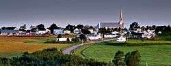
Saint-Clément is a parish municipality in the Canadian province of Quebec, located in Les Basques Regional County Municipality in the Bas-Saint-Laurent region.
Demographics
Population
| Canada census – Saint-Clément, Quebec community profile | |||
|---|---|---|---|
| 2011 | 2006 | 2001 | |
| Population: | 499 (-4.2% from 2006) | 521 (-1.9% from 2001) | 531 (-6.2% from 1996) |
| Land area: | 87.98 km2 (33.97 sq mi) | 87.98 km2 (33.97 sq mi) | 87.98 km2 (33.97 sq mi) |
| Population density: | 5.7/km2 (15/sq mi) | 5.9/km2 (15/sq mi) | 6.0/km2 (16/sq mi) |
| Median age: | 43.4 (M: 44.5, F: 42.4) | 39.9 (M: 40.2, F: 39.5) | 38.1 (M: 38.2, F: 37.5) |
| Total private dwellings: | 235 | 240 | 239 |
| Median household income: | $43,675 | $36,932 | $29,287 |
| References: 2011[4] 2006[5] 2001[6] | |||
| Historical Census Data - Saint-Clément, Quebec[7] | ||
|---|---|---|
| Year | Pop. | ±% |
| 1991 | 580 | — |
| 1996 | 566 | −2.4% |
| 2001 | 531 | −6.2% |
| 2006 | 521 | −1.9% |
| 2011 | 499 | −4.2% |
Language
| Canada Census Mother Tongue - Saint-Clément, Quebec[7] | ||||||||||||||||||
|---|---|---|---|---|---|---|---|---|---|---|---|---|---|---|---|---|---|---|
| Census | Total | French |
English |
French & English |
Other | |||||||||||||
| Year | Responses | Count | Trend | Pop % | Count | Trend | Pop % | Count | Trend | Pop % | Count | Trend | Pop % | |||||
| 2011 |
500 |
495 | |
99.00% | 5 | |
1.00% | 0 | |
0.00% | 0 | |
0.00% | |||||
| 2006 |
515 |
515 | |
100.00% | 0 | |
0.00% | 0 | |
0.00% | 0 | |
0.00% | |||||
| 2001 |
525 |
525 | |
100.00% | 0 | |
0.00% | 0 | |
0.00% | 0 | |
0.00% | |||||
| 1996 |
600 |
600 | n/a | 100.00% | 0 | n/a | 0.00% | 0 | n/a | 0.00% | 0 | n/a | 0.00% | |||||
See also
References
- ↑ Reference number 55841 of the Commission de toponymie du Québec (French)
- 1 2 Geographic code 11005 in the official Répertoire des municipalités (French)
- 1 2 "(Code 2411005) Census Profile". 2011 census. Statistics Canada. 2012.
- ↑ "2011 Community Profiles". Canada 2011 Census. Statistics Canada. July 5, 2013. Retrieved 2014-03-11.
- ↑ "2006 Community Profiles". Canada 2006 Census. Statistics Canada. March 30, 2011. Retrieved 2014-03-11.
- ↑ "2001 Community Profiles". Canada 2001 Census. Statistics Canada. February 17, 2012. Retrieved 2014-03-11.
- 1 2 Statistics Canada: 1996, 2001, 2006, 2011 census
External links
-
 Media related to Saint-Clément, Quebec at Wikimedia Commons
 |
Saint-Éloi | Saint-Jean-de-Dieu | | |
| Saint-Paul-de-la-Croix | |
|||
| ||||
| | ||||
| Saint-François-Xavier-de-Viger | Saint-Hubert-de-Rivière-du-Loup | Saint-Cyprien |
| Cities & Towns | |
|---|---|
| Municipalities | |
| Parishes | |
| Unorganized territories | |
| |
This article is issued from Wikipedia - version of the 12/1/2016. The text is available under the Creative Commons Attribution/Share Alike but additional terms may apply for the media files.