Saint-Hilarion, Quebec
| Saint-Hilarion | |
|---|---|
| Parish municipality | |
 | |
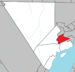 Location within Charlevoix RCM. | |
 Saint-Hilarion Location in central Quebec. | |
| Coordinates: 47°34′N 70°24′W / 47.567°N 70.400°WCoordinates: 47°34′N 70°24′W / 47.567°N 70.400°W[1] | |
| Country |
|
| Province |
|
| Region | Capitale-Nationale |
| RCM | Charlevoix |
| Constituted | July 1, 1855 |
| Government[2] | |
| • Mayor | Rosaire Lavoie |
| • Federal riding |
Montmorency—Charlevoix —Haute-Côte-Nord |
| • Prov. riding | Charlevoix–Côte-de-Beaupré |
| Area[2][3] | |
| • Total | 101.00 km2 (39.00 sq mi) |
| • Land | 99.65 km2 (38.48 sq mi) |
| Population (2011)[3] | |
| • Total | 1,181 |
| • Density | 11.9/km2 (31/sq mi) |
| • Pop 2006-2011 |
|
| • Dwellings | 572 |
| Time zone | EST (UTC−5) |
| • Summer (DST) | EDT (UTC−4) |
| Postal code(s) | G0A 3V0 |
| Area code(s) | 418 and 581 |
| Highways |
|
| Website |
www |
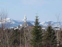
Saint-Hilarion is a parish municipality in the Capitale-Nationale region of the province of Quebec in Canada.
Demographics
Population trend:[4]
- Population in 2011: 1181 (2006 to 2011 population change: -0.8 %)
- Population in 2006: 1191
- Population in 2001: 1148
- Population in 1996: 1215
- Population in 1991: 1185
Private dwellings occupied by usual residents: 466 (total dwellings: 572)
Mother tongue:
- English as first language: 0%
- French as first language: 100%
- English and French as first language: 0%
- Other as first language: 0%
References
- ↑ Reference number 56727 of the Commission de toponymie du Québec (French)
- 1 2 Ministère des Affaires municipales, des Régions et de l'Occupation du territoire - Répertoire des municipalités: Saint-Hilarion
- 1 2 "Saint-Hilarion census profile". Statistics Canada, 2011 Census of Population. 2007-03-13. Retrieved 2007-07-20.
- ↑ Statistics Canada: 1996, 2001, 2006, 2011 census
 |
Notre-Dame-des-Monts | La Malbaie | | |
| Saint-Urbain | |
Saint-Irénée | ||
| ||||
| | ||||
| Baie-Saint-Paul | Les Éboulements |
| Cities & towns | |
|---|---|
| Municipalities | |
| Parishes | |
| Unorganized territories | |
| |
This article is issued from Wikipedia - version of the 12/20/2013. The text is available under the Creative Commons Attribution/Share Alike but additional terms may apply for the media files.