Saint-Joachim, Quebec
| Saint-Joachim | |
|---|---|
| Parish municipality | |
 | |
 Location within La Côte-de-Beaupré RCM. | |
 Saint-Joachim Location in central Quebec. | |
| Coordinates: 47°03′N 70°51′W / 47.050°N 70.850°WCoordinates: 47°03′N 70°51′W / 47.050°N 70.850°W[1] | |
| Country |
|
| Province |
|
| Region | Capitale-Nationale |
| RCM | La Côte-de-Beaupré |
| Constituted | July 1, 1855 |
| Government[2] | |
| • Mayor | Marc Dubeau |
| • Federal riding |
Montmorency—Charlevoix —Haute-Côte-Nord |
| • Prov. riding | Charlevoix–Côte-de-Beaupré |
| Area[2][3] | |
| • Total | 35.10 km2 (13.55 sq mi) |
| • Land | 42.61 km2 (16.45 sq mi) |
|
There is an apparent contradiction between two authoritative sources | |
| Population (2011)[4] | |
| • Total | 1,471 |
| • Density | 34.5/km2 (89/sq mi) |
| • Pop 2006-2011 |
|
| • Dwellings | 661 |
| Time zone | EST (UTC−5) |
| • Summer (DST) | EDT (UTC−4) |
| Postal code(s) | G0A 3X0 |
| Area code(s) | 418 and 581 |
| Highways |
|
| Website |
www |
Saint-Joachim is a parish municipality in Quebec, Canada. It is part of the La Côte-de-Beaupré Regional County Municipality in the Capitale-Nationale region. Located at the foot of Cape Tourmente, it is home to the Cap Tourmente National Wildlife Area.
History
The area, first called after Cape Tourmente, is one of the first places of New France to be colonized. In 1628, it was destroyed by the Kirke Brothers but it became an agricultural centre again after 1668 when François de Laval bought land around the cape to establish farms to feed his Seminary of Quebec. A few years later, the Saint-Joachim Parish was founded, and the place became known by the parish name.[1]
In 1845, the parish municipality was formed, but abolished in 1847, and reestablished in 1855.[1]
In 1916, Saint-Joachim lost large portions of its territory when the Parish Municipality of Saint-Louis-de-Gonzague-du-Cap-Tourmente was created to separate the lands and buildings belonging to the seminary from Saint-Joachim. However, except for a small enclave, these lands have returned to Saint-Joachim over time.[5]
Demographics
In the 2011 Census, Statistics Canada originally reported that Saint-Joachim had a population of 1,458 living in 602 of its 650 total dwellings, a 7.0% change from its 2006 population of 1,362.[6] Statistics Canada subsequently amended the 2011 census results to a population of 1,471 living in 609 of its 661 total dwellings, an 8.0% change from 2006.[4] With a land area of 42.61 km2 (16.45 sq mi), it had a population density of 34.522/km2 (89.41/sq mi) in 2011.[4][6]
Population trend:[7]
- Population in 2011: 1,471 (revised from 1,458 by Statistics Canada)[4]
- Population in 2006: 1,362
- Population in 2001: 1,471
- Population in 1996: 1,493
- Population in 1991: 1,478
Private dwellings occupied by usual residents: 609 (total dwellings: 661)[4]
Mother tongue:
- English as first language: 0%
- French as first language: 100%
- English and French as first language: 0%
- Other as first language: 0%
Image gallery
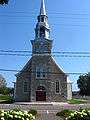 Saint-Joachim church, built between 1777 and 1779
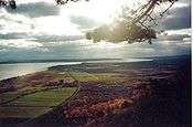 View from Cape Tourmente over Saint-Joachim's countryside
 Scenery at Cap Tourmente Wildlife Area with Mont-Sainte-Anne in the background
See also
References
- 1 2 3 "Saint-Joachim (Municipalité de paroisse)" (in French). Commission de toponymie du Québec. Retrieved 2010-04-27.
- 1 2 Ministère des Affaires municipales, des Régions et de l'Occupation du territoire - Répertoire des municipalités: Saint-Joachim
- ↑ Statistics Canada 2011 Census - Saint-Joachim census profile
- 1 2 3 4 5 "Corrections and updates". Statistics Canada. 2012-09-19. Retrieved 2012-10-13.
- ↑ "Saint-Louis-de-Gonzague-du-Cap-Tourmente (Municipalité de paroisse)" (in French). Commission de toponymie du Québec. Retrieved 2010-04-27.
- 1 2 "Population and dwelling counts, for Canada, provinces and territories, and census subdivisions (municipalities), 2011 and 2006 censuses (Quebec)". Statistics Canada. 2012-02-08. Retrieved 2012-10-13.
- ↑ Statistics Canada: 1996, 2001, 2006, 2011 census
 |
Saint-Ferréol-les-Neiges | Saint-Tite-des-Caps | | |
| Beaupré | |
Sault-au-Cochon | ||
| ||||
| | ||||
| Saint Lawrence River / Saint-François-de-l'Île-d'Orléans | Saint Lawrence River / Berthier-sur-Mer | Saint Lawrence River / Montmagny |
| Cities & towns | |
|---|---|
| Municipalities | |
| Parishes | |
| Unorganized territories | |
| |