Saint-Malo, Quebec
| Saint-Malo | |
|---|---|
| Municipality | |
 | |
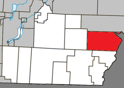 Location within Coaticook RCM. | |
 Saint-Malo Location in southern Quebec. | |
| Coordinates: 45°12′N 71°30′W / 45.200°N 71.500°WCoordinates: 45°12′N 71°30′W / 45.200°N 71.500°W[1] | |
| Country |
|
| Province |
|
| Region | Estrie |
| RCM | Coaticook |
| Constituted | January 1, 1870 |
| Government[2] | |
| • Mayor | Jacques Madore |
| • Federal riding | Compton—Stanstead |
| • Prov. riding | Saint-François |
| Area[2][3] | |
| • Total | 133.10 km2 (51.39 sq mi) |
| • Land | 131.62 km2 (50.82 sq mi) |
| Population (2011)[3] | |
| • Total | 483 |
| • Density | 3.7/km2 (10/sq mi) |
| • Pop 2006-2011 |
|
| • Dwellings | 242 |
| Time zone | EST (UTC−5) |
| • Summer (DST) | EDT (UTC−4) |
| Postal code(s) | J0B 2Y0 |
| Area code(s) | 819 |
| Highways |
|
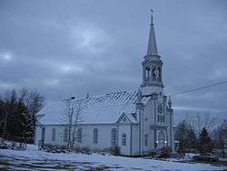
Saint-Malo is a municipality in Quebec, Canada, on the Canada–United States border. Saint-Malo has the highest elevation of any municipality in Quebec. At 640 metres (2,100 ft), local residents live in an environment of forests, farms, and waterways that supply their livelihood.
Every September, Saint-Malo holds a Harvest Festival that includes a “country” mass. A popular point of interest is La Montagnaise, a 10 metres (33 ft)-tall observation tower built in 1995, that offers panoramic views of the countryside.
History
The parish of Saint-Malo was established in 1863 by Canadiens and was incorporated as a municipality in 1910. The town's name evokes the Welsh monk Malo, missionary bishop of Brittany, and refers to the hometown of Jacques Cartier, explorer of the New World.
Demographics
Population
Population trend:[4]
| Census | Population | Change (%) |
|---|---|---|
| 2011 | 483 | |
| ADJ | 538 | |
| 2006 | 516 | |
| 2001 | 518 | |
| ADJ | 546 | |
| 1996 | 375 | |
| 1991 | 401 | N/A |
ADJ = adjusted figures due to boundary changes between census years
Sister City and Village
Known persons from this town
- Émilie Lévesque, singer (participated in Star Académie 2009)
- Michel Petit, NHL ice hockey player.
References
- ↑ Reference number 57165 of the Commission de toponymie du Québec (French)
- 1 2 Geographic code 44003 in the official Répertoire des municipalités (French)
- 1 2 "(Code 2444003) Census Profile". 2011 census. Statistics Canada. 2012.
- ↑ Statistics Canada: 1996, 2001, 2006, 2011 census
 |
Saint-Isidore-de-Clifton | | ||
| Sainte-Edwidge-de-Clifton | |
Pittsburg, New Hampshire | ||
| ||||
| | ||||
| Saint-Herménégilde | Saint-Venant-de-Paquette |
| Cities | |
|---|---|
| Municipalities | |
| Townships | |
| |
| Wikimedia Commons has media related to Saint-Malo (Québec). |