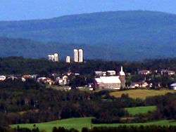
Saint-Valérien, Quebec
| Saint-Valérien | |
|---|---|
| Parish municipality | |
 | |
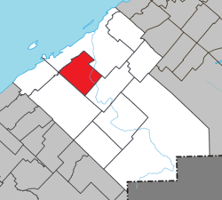 Location within Rimouski-Neigette RCM | |
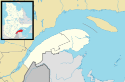 Saint-Valérien Location in eastern Quebec | |
| Coordinates: 48°20′00″N 68°40′00″W / 48.3333°N 68.6667°WCoordinates: 48°20′00″N 68°40′00″W / 48.3333°N 68.6667°W[1] | |
| Country |
|
| Province |
|
| Region | Bas-Saint-Laurent |
| RCM | Rimouski-Neigette |
| Constituted | June 19, 1885 |
| Government[2] | |
| • Mayor | Robert Savoie |
| • Federal riding | Rimouski-Neigette—Témiscouata—Les Basques |
| • Prov. riding | Rimouski |
| Area[2][3] | |
| • Total | 146.70 km2 (56.64 sq mi) |
| • Land | 144.96 km2 (55.97 sq mi) |
| Population (2011)[3] | |
| • Total | 893 |
| • Density | 6.2/km2 (16/sq mi) |
| • Pop 2006-2011 |
|
| • Dwellings | 437 |
| Time zone | EST (UTC−5) |
| • Summer (DST) | EDT (UTC−4) |
| Postal code(s) | G0L 4E0 |
| Area code(s) | 418 and 581 |
| Highways | No major routes |
| Website |
www |
Saint-Valérien is a parish municipality in the Canadian province of Quebec, located in the Rimouski-Neigette Regional County Municipality.
See also
References
External links
![]() Media related to Saint-Valérien, Quebec at Wikimedia Commons
Media related to Saint-Valérien, Quebec at Wikimedia Commons
 |
Rimouski | |
Rimouski | |
| Saint-Fabien | |
|||
| ||||
| | ||||
| Saint-Eugène-de-Ladrière | |
Saint-Narcisse-de-Rimouski |
| Cities & Towns | |
|---|---|
| Municipalities | |
| Parishes | |
| Unorganized territories | |
| |
This article is issued from Wikipedia - version of the 12/1/2016. The text is available under the Creative Commons Attribution/Share Alike but additional terms may apply for the media files.