Saint Patrick Parish, Saint Vincent and the Grenadines
| Saint Patrick Parish | |
|---|---|
| Parish | |
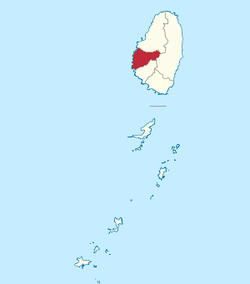 Map of the Parish of Saint Patrick | |
| Coordinates: VC 13°13′59″N 061°16′01″W / 13.23306°N 61.26694°WCoordinates: VC 13°13′59″N 061°16′01″W / 13.23306°N 61.26694°W | |
| Country | Saint Vincent and the Grenadines |
| Capital City | Barrouallie |
| Area | |
| • Total | 14 sq mi (37 km2) |
| Population | |
| • Total | 5,800 |
Saint Patrick is an administrative parish of Saint Vincent and the Grenadines, on the island of Saint Vincent. The parish consists of the middle portion of the leeward side of the main island. Its capital is Barrouallie.
- Area: 37 km² (14 mi²)
- Population: 5,800 (2000 estimates)
Populated places
The following populated places are located within the parish of Saint Patrick:[1]
- Barrouallie (13°14′09″N 061°16′19″W / 13.23583°N 61.27194°W)[2]
- Hermitage (13°14′N 061°13′W / 13.233°N 61.217°W)
- Layou (13°12′12″N 061°16′07″W / 13.20333°N 61.26861°W)[3]
- Rutland Vale (13°12′N 061°17′W / 13.200°N 61.283°W)
- Spring Village (13°15′N 061°14′W / 13.250°N 61.233°W)
References
- ↑ "GeoNames Search". National Geospatial-Intelligence Agency. Retrieved 2 March 2013.
- ↑ "Barrouallie". Wikimapia. Retrieved 3 March 2013.
- ↑ "Layou". Wikimapia. Retrieved 3 March 2013.
External links
- Parishes of Saint Vincent and the Grenadines, Statoids.com
This article is issued from Wikipedia - version of the 9/3/2016. The text is available under the Creative Commons Attribution/Share Alike but additional terms may apply for the media files.