Sakae, Nagano
| Sakae 栄村 | |
|---|---|
| Village | |
|
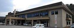
Sakae village hall | |
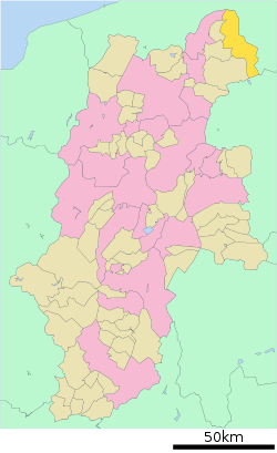 Location of Sakae in Nagano Prefecture | |
 Sakae Location in Japan | |
| Coordinates: 36°59′N 138°35′E / 36.983°N 138.583°ECoordinates: 36°59′N 138°35′E / 36.983°N 138.583°E | |
| Country | Japan |
| Region |
Chūbu Kōshin'etsu |
| Prefecture | Nagano Prefecture |
| District | Shimominochi |
| Area | |
| • Total | 271.51 km2 (104.83 sq mi) |
| Population (2003) | |
| • Total | 2,527 |
| • Density | 9.3/km2 (24/sq mi) |
| Time zone | Japan Standard Time (UTC+9) |
| Website |
www |
Sakae (栄村 Sakae-mura) is a village located in Shimominochi District, Nagano Prefecture, Japan. Situated in the northeast corner of the prefecture, the village borders neighboring Niigata.
As of 2003, the village had an estimated population of 2,527 and a density of 9.31 persons per km². The total area is 271.51 km².
Through the northern part of the village, the Chikuma River flows from west to east. The JR Iiyama Line runs along this river valley. The southern part of the village includes the remote area of Akiyama-go.
External links
 Media related to Sakae, Nagano at Wikimedia Commons
- Sakae official website (Japanese)
This article is issued from Wikipedia - version of the 11/9/2015. The text is available under the Creative Commons Attribution/Share Alike but additional terms may apply for the media files.