Salinas, Ecuador
| Salinas | |
|---|---|
| City | |
|
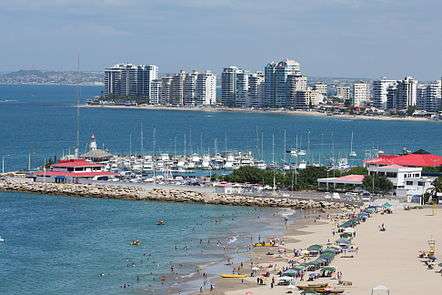
Salinas beach | |
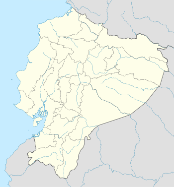 Salinas Location in Ecuador | |
| Coordinates: EC 2°13′00.12″S 80°57′00.24″W / 2.2167000°S 80.9500667°WCoordinates: EC 2°13′00.12″S 80°57′00.24″W / 2.2167000°S 80.9500667°W | |
| Country |
|
| Province | Santa Elena |
| Canton | Salinas |
| Parishes |
List of urban parishes
|
| Government | |
| • Mayor | Vinicio Yagual |
| Area | |
| • City | 27 km2 (10 sq mi) |
| • Metro | 73.5 km2 (28.4 sq mi) |
| Population (2010) | |
| • City | 50,000 |
| • Density | 1,900/km2 (4,800/sq mi) |
| • Metro | 200,000 |
| Time zone | ECT (UTC-5) |
| Climate | BWh |
| Website | http://www.municipiodesalinas.gov.ec/ |

Salinas is a coastal city located in the Province of Santa Elena, Ecuador. It is the seat of the canton that bears its name. The westernmost city on mainland Ecuador, Salinas is an important tourist center. Salinas, Ecuador’s largest coastal resort, offers one of the country’s best real estate investment markets and most popular and most upscale beach lifestyle. Recently, Salinas was the center of controversy during the contentious "more fun, less sun," debate. It is the site of the ISA World Junior Surfing Games Ecuador in 2009. There are two major yacht clubs in Salinas, the first is Salinas Yacht Club, which is a good bit smaller than the Puerto Lucia Yacht Club, in Santa Elena, in an area known as 'La Libertad' which, in Spanish means; 'The Freedom Town'. Puerto Lucia boasts a hotel, several restaurants to eat, a private beach and apartment block buildings, as well as the large marina and port.
Formerly a small fishing village until the June 30, 1929 was established as a rural parish of Santa Elena, which belonged to the December 22, 1937, when by official decree signed by the Commander in Chief, General Alberto Enriquez Gallo and published in Official Gazette No. 52 of December 27 of that year, was elevated to the rank of Canton. Its cantonal head is modern and progressive spa town of Salinas, the main tourist attraction of the Ecuadorian coast, and is composed of the rural parishes Ancon, and Jose Luis Tamayo Anconcito (Muey).
Political division
Salinas is divided into four urban parishes. They are:
- Alberto Enriquez Gallo
- Carlos Espinoza Larrea
- Santa Rosa
- Vicente Rocafuerte


Economy and Attractions
Salinas Museum 21st Century
Located in the canton street Salinas Guayas and Quil Pier and is known as "The Museum of the Great Peninsula", has an archaeological room, a temporary exhibition hall, a lounge and a naval parade, are the component cultural museum.
The Archaeological room has a complete sample of the cultures that settled in this great peninsula, real cultures Valdivia, Machalilla Engoroy (CV) of the Formative period (4200 BC - 500 BC), and Jambelí Guangala Regional Development period (500 BC - 500) and maintenance-Integration Guancavilca period (500-1530), which include human and animal figurines, ceremonial and utilitarian vessels, bottles, whistle, stone axes, beads necklaces Spondylus, horns and whistles and a variety of both cylindrical and flat seals.
On displays is a model of a raft-Guancavilca Manteña reproduced according to the description of Samano 1526. The Guancavilcas large rafts were in their black-colored vessels, hands and stone metate for grinding grains, spherical stone weights for nets and pointed to the divers who were also used to hit and release Spondylus shells attached to rocks ; copper objects such as axes and hatchets handle coins and Spondylus shell accounts, circular and rectangular shapes that were marketed along with the copper material, in Mexico and Peru, are evidence of the last thousand years of navigation our country. A model that reproduces the galleon Jesus Maria de la Limpia Concepcion known as "The Captain" takes us back to colonial times and the exhibit showcases the salvage in that galleon wrecked in 1654 off the coast of Chanduy. Coins of 1, 2, 4 and 8 reales cobs or crushed calls were made in silver and transported on ships to Panama and from there to the Caribbean to be transported to Europe, fragments of silver cutlery and plates and pottery known as majolica bars, tin, silver, cannonballs both bronze and iron and lead for muskets. A gold cross with Latin inscriptions, an earring with pearl bases, burner and silver candelabra, a buckle, metal earrings agate and correspond to the material used for personal use by the passengers on this ship and ran aground off the coast of the town of El Real.
Punta Carnero Beach
People travel from all over the world because the Surfing in Ecuador offers ideal climate all year round. Punta Carnero is a beach located approximately ten minutes south of Salinas. Its name, “Ram Point” in English, stems from the rocky headland located at the southeast end of the beach. Punta Carnero Beach has been chosen many times to be the venue of not just national surf competitions, but also at an international level.
The beach extends for approximately 1.6 miles (2.57 kilometers) and is relatively wide, with white to gray sand, medium waves and a prevalent inland breeze.
Many who travel to Punta Carnero also take a visit to other famous beaches are found just off the coast of Ecuador by 972 km is known the world over, the Galápagos Islands an area of volcanic islands distributed around the equator in the Pacific Ocean.
Other attractions
Other attractions of popular activities include:
- The diving on the island of Peel in Ayangue.
- Deep sea fishing
- La Chocolatera, choco meaning to hit or collide and la tera meaning ground, a large cliff that is the most salient point of the Peninsula of Santa Elena where the north and south moving currents colide.
- Central Church of Our Lady of Mercy.
- Main Salinas Malecon and Chipipe
- San Lorenzo Park Civic.
- Paseo Artesanal Los Cedros.
- Malecón de Santa Rosa.
- Park and Central Church of José Luis Tamayo.
- Pacific Mall.
- Anconcito Malecon.
- Whale Museum
- Whale watching
- Parasailing
References
- www.inec.gov.ec
- Taxi Salinas Guayaquil Transportation Salinas Guayaquil.