Salwarpe
| Salwarpe | |
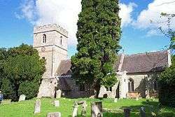 St Michael and All Angels, Salwarpe |
|
 Salwarpe |
|
| Civil parish | Hindlip, Martin Hussingtree, and Salwarpe |
|---|---|
| District | Wychavon |
| Shire county | Worcestershire |
| Region | West Midlands |
| Country | England |
| Sovereign state | United Kingdom |
| Post town | DROITWICH |
| Postcode district | WR9 |
| Police | West Mercia |
| Fire | Hereford and Worcester |
| Ambulance | West Midlands |
| EU Parliament | West Midlands |
|
|
Coordinates: 52°15′25″N 2°11′06″W / 52.257°N 2.185°W
Salwarpe is a small village in the Wychavon district of Worcestershire, England, less than two miles south west of Droitwich, but in open country. The name is also spelled Salwarp, and in the time of John Leland was recorded as Salop. No longer a civil parish in its own right, Salwarpe now shares a parish council with Hindlip and Martin Hussingtree.
History
A Saxon charter of the year 817 records that Coenwulf, King of Mercia, granted the manor of Salwarpe to Denebeorht, Bishop of Worcester, and his Priory.[1] By the 11th century, the grant had been alienated, and a nobleman named Godwine had possession of the principal manor of Salwarpe, while his brother Leofric, Earl of Mercia, was a lesser landowner there. As Godwine was dying about 1052, Saint Wulfstan, who was Dean of Worcester, persuaded him to give his manor of Salwarpe back to Worcester Priory, but Godwine's son Ethelwine (named in the Domesday Book as being in possession in the time of King Edward) repudiated his father's Will and kept it, denying the bequest to the Priory.[1] Salwarpe was in the ancient hundred of Clent.[2]
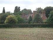
By 1086 the Norman Urse d'Abetot had acquired an estate in Worcestershire which became the Barony of Salwarpe,[3] and Salwarpe Court, a substantial country house, was later a seat of the Earls of Warwick. In 1351 this house was the birthplace of Richard Beauchamp, 13th Earl of Warwick.[1][4] It was rebuilt for a new owner, Sir John Talbot, in the time of Queen Elizabeth.[1] In this era the Domesday hundreds of Clent and Cresslow were combined to form Halfshire hundred.[5]
The ancient parish of Salwarpe contains several hamlets. The early nineteenth-century enclosure map shows Boycott, Chauson, Copcott, High Park, Hill End, Ladywood, Middleton, Newland, and Oakley, and most of these names were also recorded in the 17th century.[1][6]
The Church of England parish church, dedicated to St Michael and All Angels, is unusually large for a village now so small, but it reflects greater importance in past centuries. Parts of the church are Norman.[7]
In 1868, the National Gazetteer of Great Britain and Ireland said
SALWARPE, a parish in the borough of Droitwich, upper division of Halfshire hundred, county Worcester, 5½ miles N. of Worcester, its post town, and 2 S.W. of Droitwich. The village, which is of small extent, is situated on the Droitwich canal and the river Salwarpe; the latter takes its rise under Lickey hills, thence flows 14 miles S.W. past Bromsgrove, Stoke-Prior, and Droitwich, to the Severn, at Hawford Bridge. Salwarpe, in Leland's time, was called Salop. The celebrated Earl of Warwick, Richard Beauchamp, was born here in 1351.[8]
Geography
The River Salwarpe rises near Bromsgrove and passes Stoke Prior, Upton Warren, Wychbold, Salwarpe, and Droitwich, after which it meets the River Severn at Hawford. The 18th century Droitwich Canal also passes near the village.[9]
The BBC's Droitwich Transmitting Station, established in 1934, is a few miles north of the village.[10]
Notable people
- Nathaniel Torporley (1564–1632), Rector of Salwarpe 1608–1622[11][12]
- Richard Beauchamp, 13th Earl of Warwick, born at Salwarpe 1351[4]
- Sir John Talbot (1630-1714), soldier and politician, had his country seat at Salwarpe

Notes
- 1 2 3 4 5 A History of the County of Worcester (volume 3, 1913), pp. 205-210 online
- ↑ http://opendomesday.org/place/SO8762/salwarpe/ Open Domesday Map: Salwarpe
- ↑ Stephanie L. Mooers, 'Familial Clout and Financial Gain in Henry I's Later Reign' in Albion vol. 14, issues 3 & 4, Winter 1982, pp. 268–291
- 1 2 Richard Gough, Description of the Beauchamp chapel, adjoining to the church of St. Mary, at Warwick. And the monuments of the earls of Warwick, in the said church and elsewhere (Warwick Town, St Mary, 1803), p. 17
- ↑ http://opendomesday.org/search/?geo=halfshire Open Domesday Map: Halfshire hundred
- ↑ Joan R. Kent, The English Village Constable 1580-1642 (1986), p. 85
- ↑ Della Hooke, Worcestershire Anglo-Saxon Charter-Bounds (1990, ISBN 0851152767), p. 198
- ↑ National Gazetteer of Great Britain and Ireland (1868)
- ↑ George K. Stanton, Rambles and Researches among Worcestershire churches (vol. 1, 1884), p. 234
- ↑ The Droitwich Transmitting Station [booklet] (British Broadcasting Corporation, 1937
- ↑ Robert Fox, Thomas Harriot: An Elizabethan Man of Science (2000), p. 288
- ↑ A. D. Wraight, In search of Christopher Marlowe: a pictorial biography (1965), p. 150
| Wikimedia Commons has media related to Salwarpe, Worcestershire. |
External links
- St Michael's Church, Salwarpe at shmhchurches.com
- Salwarpe at genuki.org.uk