Samjeondo Monument
| Samjeondo Monument | |
 | |
| Korean name | |
|---|---|
| Hangul | 삼전도비 |
| Hanja | 三田渡碑 |
| Revised Romanization | Samjeondobi |
| McCune–Reischauer | Samjŏndobi |
| Chinese Wikisource has original text related to this article: |
The Samjeondo Monument is a monument marking Joseon Korea's submission to Manchu Qing Dynasty in 1636 after Second Manchu invasion of Korea. its original name was Daecheong Hwangje Gongdeok Bi (大淸皇帝功德碑) which means the stele to the merits and virtues of the Emperor of Great Qing. Initially erected at Samjeondo, near the Sambatnaru crossing point of the Han River, it was thereafter buried and erected again several times. It is nowadays designated as the 101st Historic site of South Korea.
Erection
Following the siege of Namhansanseong, King Injo of Joseon had to surrender and was forced to accept vassal status to the Manchu Empire in 1636. The following year, Hong Taiji, Emperor of the Qing Dynasty, ordered King Injo to put up a monument "in honor of the excellent virtues of the Qing Emperor". In 1639 it was erected at Samjeondo, where the ceremony of surrender had been conducted.[1] Inscriptions were written in Manchu and Mongolian on the front side and in Hanja on the back; they have almost identical contents. The Hanja version was composed by Yi Gyeongseok (李景奭), and the rest seem to have been translated from it.
Samjeondo, meaning "crossing of the three fields", was located near the Sambatnaru, a major crossing point of the Han River in early Joseon times. The Sambatnaru way was the shortest route to the stronghold of Gwangju and the southern provinces. It was also the one most often used to visit the tomb of King Taejong at the foot of Mt. Daemosan.
Timeline
Because of the strong emotional charge attached to it, this monument has been buried down and then erected again several times from 1639 till nowadays.
- 1895. The monument was buried down as a result of the Treaty of Shimonoseki that concluded the First Sino-Japanese War(1894-1895).
- 1913. The monument is erected again.
- ???. The monument is buried down after 1945. During Syngman Rhee's presidency (1948–1960), orders were given to destroy the stele, but the Ministry of Culture had it buried instead.[2]
- 1957. South Korean Government appoints the site as Historic Site No 101 (1957/02/01).[3]
- 1963. The monument comes again to the eyes due to a flood of the river.
- 1983. Monument is placed in a park, 37.503351 N,127.107083 E,[4][5] i.e. in Seokchon-dong, Songpa-gu, Seoul, South Korea
Names
- in Manchu: Daicing gurun-i Enduringge Han-i gung erdemui bei (
 )
) - in Mongolian: Dayičing ulus-un Boγda Qaγan-u erdem bilig-i daγurisγaγsan bei (
 )
) - in Hanja: Daecheong Hwangje Gongdeok Bi (大清皇帝功德碑)
which can be translated as "the stele to the merits and virtues of the Emperor of Great Qing."
Contents
Description
Both the Manchu and Koreans saw the inscription as the litmus test for Korea's attitude toward the Manchu Emperor, so King Injo frayed his nerves to it. As a result, it greatly flattered the Manchus; namely, the inscription narrates how the king of Korea came to attach himself to the virtue of the Manchu Emperor from a Korean point of view. Although one-sided, it provides a concise account of the Manchu-Korean relationship.
The inscription starts with the description of the second Manchu campaign against Korea in 1636. The Manchu army besieged the Namhan fortress, where King Injo took refuge. He admitted his guilt, accepted the imperial edict and surrendered at Samjeondo. Since Hong Taiji felt compassion for the king, he mercifully sent the king back to the capital and rapidly withdrew the army without doing harm to the people.
In the next paragraph, the inscription traces the history back to the Battle of Sarhū in 1619. The Korean army, led by Gang Hong-rip, put on the appearance of supporting the Ming Dynasty but surrendered to the Manchus. However, all of the soldiers except the high-ranking ones were released by Nurhaci, and the inscription emphasizes the merciful act. Since Korea still displayed disobedient behavior, Hong Taiji commenced the first Manchu invasion of Korea in 1627. He did not overthrow the kingdom but established a Confucian "elder brother-younger brother" relationship. The inscription then goes on to describe the second Manchu campaign. When Hong Taiji declared the new dynasty of Qing in 1636, Korea did not accept it even though the Empire announced a war. The inscription stressed his benevolent acts during the war.
Next, the inscription explains the background of erection of the monument. It says that the king voluntarily erected the monument at Samjeondo to let the excellent virtue of the Emperor be known around the world.
Finally, the inscription summarizes the entire course of events in verse.
Gallery
- New location, reverse
 Stone tortoise
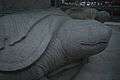 Stone tortoise
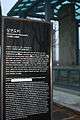 Historic context
 Plaque relating details of the stele's relocation
 Stele at its previous location
 The two tortoises
 Depiction of kneeling Injo,created in 1983. Already demolished.
 Injo of Joseon kneeling down before the emperor of Qing Hong Taiji
 Enlarged view of the stele's reverse top-cap carvings
See also
References
- ↑ Kang, David C. (2010). East Asia Before the West: Five Centuries of Trade and Tribute. Columbia University Press. pp. 104–105.
- ↑ Keith L. Pratt et al. (editors), Korea: A Historical and Cultural Dictionary (London: Routledge, 2004), page 401.
- ↑ Songpa-gu Office. "Samjeondo Monument". Songpa-gu Office. Retrieved 29 August 2011.
- ↑ "Google Map". Retrieved 29 August 2011.
- ↑ "Panoramio". Retrieved 29 August 2011.
- ↑ "Google Map". Retrieved 29 August 2011.
- ↑ "Panoramio". Retrieved 29 August 2011.
External links
Coordinates: 37°30′38″N 127°6′6″E / 37.51056°N 127.10167°E