San Andrés Itzapa
| San Andrés Itzapa | |
|---|---|
| Municipality and town | |
 San Andrés Itzapa Location in Guatemala | |
| Coordinates: 14°37′N 90°51′W / 14.617°N 90.850°W | |
| Country |
|
| Department |
|
| Government | |
| • Major (2016-2020) | Hugo Israel Guch Ajpuac [1] |
| Area | |
| • Total | 30 sq mi (90 km2) |
| Time zone | Central Time (UTC+6) |
| Climate | Cwb |
San Andrés Itzapa (Spanish pronunciation: [anˈdɾes itˈsapa]) is a municipality of Chimaltenango, Guatemala. San Andrés Itzapa is in the eastern region of Chimaltenango, while the district capital lies to the north, Acatenango lies to the south and to the east is Parramos. The city occupies an area of 90 square kilometres, with a total of 31,956 inhabitants, who are called Itzapecos.
Origin of the name
San Andrés Itzapa (Itzapa means flint) is an ancient town. The village is mentioned in the Annals of the Cakchiquels, written in 1571. The Spanish named the area "Itzapa y de San Andrés" in honor of their patron saint, the apostle San Andrés (Saint Andrew). The Spanish also called the area "Valle del Durazno" (Valley of the peaches), as the prickly pears common in this area resembled the orchards of home.
Organization
| Subdivision | Name | Distance to municipal capital (in km) |
|---|---|---|
| Villages | Chicazanga | 5.4 |
| Chimachoy | 10.5 | |
| Panimaquin | 7 | |
| San José Calderas | 16.5 | |
| Hierba Buena | 7 | |
| El Aguacate | N/A[lower-alpha 1] | |
| San José Los Corrales | 7 | |
| Xeparquiy | 5 | |
| San José Cajahualten | 9 | |
| San Rafael | 12.5 | |
| Neighborhoods | San Cristóbal | N/A Located within the municipal capital |
| San Pedro y San Pablo | ||
| Santísima Trinidad | ||
| San Antonio | ||
| San Lorenzo Norte | ||
| San Lorenzo Sur | ||
| Residential communities |
El Edén | |
| La Primavera | ||
| Las Conchitas | ||
| Colinas de San Andrés | ||
| Canadá | ||
| Navideña | ||
| La Cuchilla | ||
| La Pinada | ||
| Los Encinos | ||
| San Francisco | ||
| El Stan[lower-alpha 2] |
Languages
Both Spanish and Kaqchiquel are spoken, although migration from other regions has brought an influx of other languages, such as K'iché and Tz'utujil.
Flora and fauna
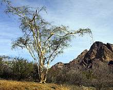
San Andrés Itzapa has several heavily forested areas, which include eucalyptus, poplars, pines, holly, oaks, cypress and other evergreen and deciduous species.
Plants found in San Andrés Itzapa include canaque, casuarina, conacaste, hormigo, grabilea and palo blanco, as well as varieties of aloe.
Animals include coyote, armadillos, mountain lions, tisote, lynxes, goyoy, kinkajou, squirrels, racoons, wild boars, dove, cayayes, pajuil, and pheasant.
Agricultural products
Wheat, cotton, corn, beans, avocado, chayote, beet, radish, squash, carrot, broccoli, cabbage, coffee and guaque Chile peppers are grown.
Crafts
The municipality is rich in the craftsmanship of leather goods such as knife and machete sheaths, sandals, articles of jade, tables and chairs, ropemaking, and others.
Celebrations
- Convite (the last Saturday of January)
- Feria Titular (from 22 November to 1 December)
- Corpus Christi (late June)
- Corrida de Cintas (15 September)
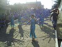
- Maximón (28 October)
- Saint Andrew the Apostle (30 November)
Places of interest
- Xipacay bath
- Temple of San Simón
Volunteer Organizations
- DOCARE Clinic - An American non-profit medical outreach program operated by the American Osteopathic Association. This clinic was established in 2011 in conjunction with Guatemalan non-profit ASSADE, employs a full-time physician and nurse, and regularly hosts medical students and physician trainees from American programs as volunteer medical providers.[3]
- Maya Pedal - small local NGO dedicated to supporting rural development through the design and production of pedal powered machines, or bicimaquinas. As of September 2012, Maya Pedal recently underwent an organizational change, please refer to the website or Facebook page for more information.[4]
- Project Genesis- Local nonprofit that provides education and community development programs to the children of San Andrés and the surrounding villages. It aims to build a school and begin employing full-time teachers. The project currently relies on international volunteers, and was founded by Ricardo Armas who lives in Jocotenango.
Climate
San Andrés Itzapa has a subtropical highland climate (Köppen: Cwb).
| Climate data for San Andrés Itzapa | |||||||||||||
|---|---|---|---|---|---|---|---|---|---|---|---|---|---|
| Month | Jan | Feb | Mar | Apr | May | Jun | Jul | Aug | Sep | Oct | Nov | Dec | Year |
| Average high °C (°F) | 21.7 (71.1) |
22.6 (72.7) |
24.2 (75.6) |
24.7 (76.5) |
24.4 (75.9) |
22.5 (72.5) |
22.7 (72.9) |
23.1 (73.6) |
22.5 (72.5) |
21.8 (71.2) |
21.9 (71.4) |
21.6 (70.9) |
22.81 (73.07) |
| Daily mean °C (°F) | 15.5 (59.9) |
16.1 (61) |
17.4 (63.3) |
18.6 (65.5) |
18.9 (66) |
18.1 (64.6) |
17.9 (64.2) |
17.9 (64.2) |
17.8 (64) |
17.1 (62.8) |
16.4 (61.5) |
15.5 (59.9) |
17.27 (63.07) |
| Average low °C (°F) | 9.3 (48.7) |
9.6 (49.3) |
10.6 (51.1) |
12.5 (54.5) |
13.4 (56.1) |
13.8 (56.8) |
13.2 (55.8) |
12.8 (55) |
13.1 (55.6) |
12.4 (54.3) |
11.0 (51.8) |
9.5 (49.1) |
11.77 (53.18) |
| Average precipitation mm (inches) | 3 (0.12) |
4 (0.16) |
4 (0.16) |
37 (1.46) |
113 (4.45) |
277 (10.91) |
199 (7.83) |
187 (7.36) |
263 (10.35) |
139 (5.47) |
36 (1.42) |
8 (0.31) |
1,270 (50) |
| Source: Climate-Data.org[5] | |||||||||||||
Geographic location
San Andrés Itzapa is surrounded by Chimaltenango Department municipalities:[2]
 |
Zaragoza | Chimaltenango | Chimaltenango | |
| Zaragoza and Patzicía | |
Parramos[2] | ||
| ||||
| | ||||
| Acatenango[2] |
See also
 Guatemala portal
-
 Geography portal
 - List of places in Guatemala
Notes and references
- ↑ Inhabited after the massacre that took place there in 1988 during Guatemala Civil War.
- ↑ Built for people affected by Hurricane Stan in 2005.
References
- ↑ "Partido UNE gana alcaldía de Chimaltenango". Prensa Libre (in Spanish). Guatemala. 8 September 2015. Retrieved 8 September 2015.
- 1 2 3 4 SEGEPLAN (2010). "Municipios de Chimaltenango" (in Spanish). Guatemala. Archived from the original on 8 June 2015. Retrieved 8 June 2015.
- ↑ "DOCARE International, Guatemala Clinic".
- ↑ "Asociación Maya Pedal".
- ↑ "Climate: San Andrés Itzapa". Climate-Data.org. Retrieved 20 September 2015.
Coordinates: 14°37′N 90°51′W / 14.617°N 90.850°W
Capital: Chimaltenango | ||
| Municipalities |  | |