San Biagio della Cima
| San Biagio della Cima | |
|---|---|
| Comune | |
| Comune di San Biagio della Cima | |
|
San Biagio della Cima | |
 San Biagio della Cima Location of San Biagio della Cima in Italy | |
| Coordinates: 43°49′N 7°39′E / 43.817°N 7.650°ECoordinates: 43°49′N 7°39′E / 43.817°N 7.650°E | |
| Country | Italy |
| Region | Liguria |
| Province / Metropolitan city | Province of Imperia (IM) |
| Area | |
| • Total | 4.6 km2 (1.8 sq mi) |
| Population (Dec. 2004) | |
| • Total | 1,226 |
| • Density | 270/km2 (690/sq mi) |
| Time zone | CET (UTC+1) |
| • Summer (DST) | CEST (UTC+2) |
| Postal code | 18030 |
| Dialing code | 0184 |

San Biagio della Cima is a comune (municipality) in the Province of Imperia in the Italian region Liguria, located about 120 kilometres (75 mi) southwest of Genoa and about 30 kilometres (19 mi) west of Imperia. As of 31 December 2004, it had a population of 1,226 and an area of 4.6 square kilometres (1.8 sq mi).[1]
Geography
San Biagio della Cima borders the following municipalities: Camporosso, Dolceacqua, Perinaldo, Soldano, Vallebona, and Vallecrosia.
History
On the 21st of April 1686, the representants of eight villages, Camporosso, Vallebona, Vallecrosia, San Biagio della Cima, Sasso, Soldano, Borghetto San Nicolò and Bordighera had a meeting in order to build what they called "Magnifica Comunità degli Otto Luoghi", which can be translated as: "The magnificent community of the eight villages". Their goal was to gain independence from the nearby rival city of Ventimiglia.[2]
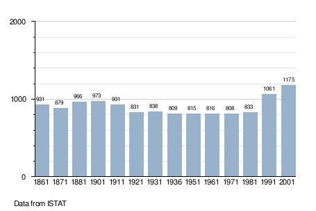
Demographic evolution
Twin towns — Sister cities
San Biagio della Cima is twinned with:
-
 Camps-la-Source, France (2005)
References
- ↑ All demographics and other statistics: Italian statistical institute Istat.
- ↑ Gandolfo, Andrea (2005). La provincia di Imperia: storia, arti, tradizioni. 1. Blu edizioni.