San Marcos La Laguna
| San Marcos La Laguna | |
|---|---|
| village | |
|
Lago Atitlan near San Marcos La Laguna | |
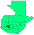
 San Marcos La Laguna Location in Guatemala | |
| Coordinates: 14°43′30″N 91°15′30″W / 14.72500°N 91.25833°W | |
| Country |
|
| Department |
|
| Government | |
| • Type | municipal |
| Elevation[1] | 1,585 m (5,200 ft) |
| Lowest elevation[1] | 1,562 m (5,125 ft) |
| Time zone | Central Time (UTC-6) |
| Country calling code | 502 |
| Climate | Aw |
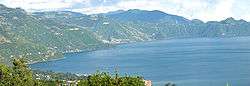
San Marcos La Laguna is a village on the western shore of Lago Atitlán in the Sololá Department of Guatemala. The village is northwest of three volcanos Volcán San Pedro, Volcán Tolimán, and Volcán Atitlán. The village has an outdoor amphitheater and a few hostels.[1] San Marcos connects to other lakeside communities by boat and a narrow road. The nearest city is Panajachel at the northern side of Lago Atitlán.[1] The town sits at an elevation of 1,585 metres (5,200 ft); the lowest elevation is the lake shore at 1,562 metres (5,125 ft).
It is a small village of 2200 inhabitants; the majority of the population are Kaqchikel-speaking indigenous Mayans.
References
External links
 San Marcos La Laguna travel guide from Wikivoyage
Coordinates: 14°43′N 91°16′W / 14.717°N 91.267°W
This article is issued from Wikipedia - version of the 3/8/2016. The text is available under the Creative Commons Attribution/Share Alike but additional terms may apply for the media files.