San Vittore, Switzerland
| San Vittore | ||
|---|---|---|
 | ||
| ||
 San Vittore | ||
|
Location of San Vittore 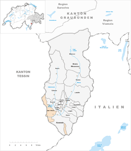 | ||
| Coordinates: 46°14′N 9°06′E / 46.233°N 9.100°ECoordinates: 46°14′N 9°06′E / 46.233°N 9.100°E | ||
| Country | Switzerland | |
| Canton | Graubünden | |
| District | Moesa | |
| Area[1] | ||
| • Total | 22.06 km2 (8.52 sq mi) | |
| Elevation | 278 m (912 ft) | |
| Population (Dec 2015[2]) | ||
| • Total | 766 | |
| • Density | 35/km2 (90/sq mi) | |
| Postal code | 6534 | |
| SFOS number | 3835 | |
| Surrounded by | Arvigo, Buseno, Castaneda, Claro (TI), Cresciano (TI), Germasino (IT-CO), Lumino (TI), Roveredo | |
| Website |
sanvittore SFSO statistics | |

San Vittore is a municipality in the district of Moesa in the Swiss canton of Grisons.
Geography

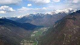
San Vittore is situated in the lower part of the valley of the Moesa river, just over 2 km (1.2 mi) upstream of the border with the canton of Ticino, and 6 km (3.7 mi) upstream of Arbedo-Castione, where the Moesa river joins the Ticino river. At 278 meters (912 ft) above sea level, it is the lowest-lying community in Graubünden.[3]
San Vittore has an area, as of 2006, of 22 km2 (8.5 sq mi). Of this area, 15.5% is used for agricultural purposes, while 66.7% is forested. Of the rest of the land, 2.8% is settled (buildings or roads) and the remainder (15%) is non-productive (rivers, glaciers or mountains).[4]
Demographics
San Vittore has a population (as of 31 December 2015) of 766.[2] As of 2008, 14.2% of the population was made up of foreign nationals.[5] Over the last 10 years the population has grown at a rate of 16.2%. Most of the population (as of 2000) speaks Italian (88.7%), with German being second most common ( 7.6%) and French being third ( 1.1%).[4]
As of 2000, the gender distribution of the population was 50.6% male and 49.4% female.[6] The age distribution, as of 2000, in San Vittore is; 82 children or 12.5% of the population are between 0 to 9 years old. 32 teenagers or 4.9% are 10 to 14, and 24 teenagers or 3.7% are 15 to 19. Of the adult population, 54 people or 8.2% of the population are between 20 to 29 years old. 126 people or 19.2% are 30 to 39, 117 people or 17.8% are 40 to 49, and 72 people or 11.0% are 50 to 59. The senior population distribution is 81 people or 12.3% of the population are between 60 to 69 years old, 40 people or 6.1% are 70 to 79, there are 25 people or 3.8% who are 80 to 89, and there are 4 people or 0.6% who are 90 to 99.[5]
In the 2007 federal election the most popular party was the SP which received 36.9% of the vote. The next three most popular parties were the SVP (29.3%), the CVP (16.7%) and the FDP (15.6%).[4]
In San Vittore about 73.5% of the population (between age 25-64) have completed either non-mandatory upper secondary education or additional higher education (either university or a Fachhochschule).[4]
San Vittore has an unemployment rate of 2.06%. As of 2005, there were 23 people employed in the primary economic sector and about 10 businesses involved in this sector. 129 people are employed in the secondary sector and there are 13 businesses in this sector. 68 people are employed in the tertiary sector, with 23 businesses in this sector.[4]
The historical population is given in the following table:[6][7]
| year | population |
|---|---|
| 1850 | 594 |
| 1900 | 517 |
| 1950 | 468 |
| 1960 | 516 |
| 1970 | 666 |
| 1980 | 555 |
| 1990 | 611 |
| 2000 | 657 |
Heritage sites of national significance
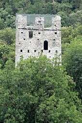
The Chapel of S. Lucio e dintorni and the Torre di Pala are listed as Swiss heritage sites of national significance.[8]
References
- ↑ Arealstatistik Standard - Gemeindedaten nach 4 Hauptbereichen
- 1 2 Swiss Federal Statistical Office - STAT-TAB, online database – Ständige und nichtständige Wohnbevölkerung nach institutionellen Gliederungen, Geburtsort und Staatsangehörigkeit (German) accessed 30 August 2016
- ↑ map.geo.admin.ch (Map). Swiss Confederation. Retrieved 2012-09-23.
- 1 2 3 4 5 Swiss Federal Statistical Office accessed 23-Oct-2009
- 1 2 Graubunden Population Statistics (German) accessed 21 September 2009
- 1 2 Graubunden in Numbers (German) accessed 21 September 2009
- ↑ San Vittore in German, French and Italian in the online Historical Dictionary of Switzerland.
- ↑ Swiss inventory of cultural property of national and regional significance 21.11.2008 version, (German) accessed 23-Oct-2009
| Wikimedia Commons has media related to San Vittore, Switzerland. |
External links
- Official website (Italian)
- San Vittore in German, French and Italian in the online Historical Dictionary of Switzerland.