Sanborn Maps
Sanborn Maps is an American publisher of historical and current maps of US cities and towns. The maps were initially created to estimate fire insurance risks. The company's maps are frequently used for historical research, and for preservation and restoration efforts.
Description
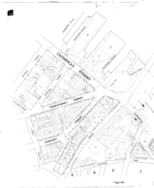
The Sanborn maps themselves are large-scale lithographed street plans at a scale of 50 feet to one inch (1:600) on 21 by 25 inches (53 by 64 cm) sheets of paper. The maps were published in volumes, bound and then updated until the subsequent volume was produced. Larger cities would have multiple volumes. In between published volumes, updates (new drawings of new or altered buildings or lots) were created and sent out to be pasted on top of the old maps (referred to as ‘slips’) to reduce expense and still preserve accuracy.
The map volumes contain an enormous amount of information. They are organized as follows: a decorative title page; an index of streets and addresses; a ‘specials’ index with the names of churches, schools, businesses etc.; and a master index indicating the entirety of the mapped area and the sheet numbers for each large-scale map (usually depicting four to six blocks); and general information such as population, economy and prevailing wind direction. The maps include outlines of each building and outbuilding; the location of windows and doors; street names; street and sidewalk widths; property boundaries; fire walls; natural features (rivers, canals, etc.); railroad corridors; building use (sometimes even particular room uses); house and block number; as well as the composition of building materials including the framing, flooring, and roofing materials; the strength of the local fire department; indications of sprinkler systems; locations of fire hydrants; location of water and gas mains; and even the names of most public buildings, churches and businesses.
History

The Sanborn Maps were originally created for assessing fire insurance liability in urbanized areas in the United States. The maps include detailed information regarding town and building information in approximately 12,000 US towns and cities from 1867 to 2007. Author Kim Keister describes the legacy of Sanborn maps: "Stated simply, the Sanborn maps survive as a guide to American urbanization that is unrivaled by other cartography and, for that matter, by few documentary resources of any kind."[1] They are a highly useful resource for historical research, planning, preservation, genealogical research, sociological studies and research of urban geography.
Mapping for insurance, and specifically fire insurance, purposes had existed for a century prior to the emergence of the Sanborn Company, first beginning in London in the late 18th century with the Phoenix Assurance Company.[2] In the decades following the end of the Civil War, fire insurance mapping grew rapidly, mirroring the flourish of growth in the country, the rebuilding of the South and massive westward expansion. Factors such as the Homestead Act, railroad construction, the Second Industrial Revolution and massive immigration to the United States all fostered huge population growths, urbanization, and heightened demand for mapping.
Daniel Alfred Sanborn, a civil engineer and surveyor, began working on fire insurance maps in 1866. That year, he was contracted by the Aetna Insurance Company to prepare maps of areas in Tennessee. About the same time, he developed similar maps of Boston, published as Insurance Map of Boston, Volume 1, 1867. Seeing a lucrative market for these types of map, he established the D. A. Sanborn National Insurance Diagram Bureau in New York City to publish the Boston atlas and develop and sell maps of additional areas.[2]
Within several decades, the company became the largest and most successful American map company. This growth came about through savvy management and the buyout of competing firms. Company headquarters moved to 629 Fifth Avenue in northern Pelham, New York, but there were also regional offices in San Francisco, Chicago, and Atlanta. The Sanborn Company sent out legions of surveyors to record the building footprints and relevant details about these buildings in all major urbanized areas regarding their fire liability. At its peak in the interwar period, the company employed about 700 people, including about 300 field surveyors and 400 cartographers, printers, managers, salesmen, and support staff.[2]
It was because of these details and the accuracy of the Sanborn maps, coupled with the Sanborn Company’s standardized symbolization and aesthetic appeal that made the Sanborn Company so successful and their maps so widely utilized.
The maps were originally created solely for insurance assessment purposes; it was said that at one time, insurance companies and their agents, “relied upon them with almost blind faith”. The maps were utilized by insurance companies to determine the liability of a particular building through all the information included on the map; building material, proximity to other buildings and fire departments, the location of gas lines et cetera. The very decision as to how much, if any insurance was to be offered to a customer was often determined solely through the use of a Sanborn map. The maps also allowed insurance companies to visualize their entire coverage areas; when an agent sold a policy he could color in the corresponding building on the map and thus visualize the companies’ coverage of an area.
Modern uses of traditional fire insurance maps

Today, Sanborn maps are found primarily in the archives and special collections of town halls and public and university libraries, and remain a vital resource for people in many different fields. Historical research is the most obvious use, with the maps facilitating the study of urban growth and decline patterns, and for research into the evolution of specific buildings, sites and districts. Genealogists use the maps to locate the residences and workplaces of ancestors. Planners use the maps to study historic urban planning designs. Historic preservationists use the maps to understand the significance and historical evolution of buildings, including their historic uses and building materials in conservation and rehabilitation efforts. Demographers and urban geographers use them to study patterns of growth and migration of populations.
Historic Sanborn maps may be accessed in a variety of ways. Many are available through public or university libraries, or most comprehensively through the Library of Congress. One may also obtain copyright information or request copies of the maps for purchase through the current owners, Environmental Data Resources, Incorporated.
Warren Buffett
Sanborn Map Company was an early holding of a young Warren Buffett in the early 1960s through his first investment partnership. Buffett advocated for change at the company, which had built a large investment portfolio over time. At one point, Sanborn Map represented 35% of total investment assets under Buffett's partnership.
Modern company
Sanborn's insurance map business began to decline after World War II, as the insurance industry began modernizing methods of assessing and mitigating risk. Sanborn could no longer afford to maintain its army of surveyors, but continued to sell its maps and perform some updates. Government sales began to play a larger role, especially the Census Bureau and municipal planning agencies.[2]
Over time, the company diversified into other mapping activities, and is today a geospatial specialist and holder of electronic GIS assets and systems, though the fire insurance business continues as a niche department. Corporate headquarters are now in Colorado.[3] The former headquarters building in Pelham, New York houses other businesses.[4]
See also
References
- ↑ Keister, Kim (May–June 1993). "Charts of Change". Historic Preservation. 45 (3): 42–49.
- 1 2 3 4 "Sanborn Fire Insurance Maps". EART (Earth Sciences and Map Library). University of California at Berkeley. 1978. Retrieved 2015-05-14.
- ↑ "Corporate home page". Total Geospatial Solutions. Sanborn. Retrieved 2015-05-14.
- ↑ "Sanborn Map Building :: History". Sanborn Maps Building. Retrieved 3 July 2015.
Further reading
- Tom Gates (2001). "Information About Digital Sanborn Maps". Kent State University, Libraries & Media Services. Retrieved 1 July 2011.
- Chris Nehls (2003). "Sanborn Fire Insurance Maps, A Brief History". Geostat Center and Department of History, University of Virginia. Retrieved 1 July 2011.
- Oswald, Diane L. (1997). Fire Insurance Maps: Their History and Applications. College Station, Texas: Lacewing Press.
- Ristow, Walter (1985). American Maps and Mapmakers. Detroit: Wayne State University Press.
- "Sanborn Fire Insurance Maps". Retrieved 20 March 2014.
External links
| Wikimedia Commons has media related to Sanborn maps. |
- Sanborn Map Company
- ProQuest Digital Sanborn Maps, 1867–1970 — pay site (free from some public and academic libraries)
- Environmental Data Resources Sanborn Maps, 1867–2007 — pay site
- Sanborn Maps from over 15 states — Library of Congress
- Sanborn Maps of Alabama, 1884–1950 — University of Alabama
- Sanborn Maps of San Francisco, California, 1900 — SF Genealogy
- Sanborn Maps of San Francisco, California, 1905 — David Rumsey
- Sanborn Maps of San Jose, California - San Jose Public Library - Digital Sanborn Fire Maps of San Jose available to library card holders
- Sanborn Maps of Colorado, 1883–1922 — University of Colorado Digital Library
- Sanborn Maps of Florida, 1860–1923 — University of Florida Library
- Sanborn Maps of Georgia, 1884–1922 — Digital Library of Georgia
- Sanborn Maps of Indianapolis, Indiana, 1887–1941 — IUPUI University Library
- Sanborn Maps of Muncie, Indiana, 1883–1911 — Ball State University Library
- Sanborn Maps of Kansas, 1883–1922 — University of Kansas Libraries
- Sanborn Maps of Kentucky, 1884–1922 — Kentuckiana Digital Library
- Sanborn Maps of Frankfort, Kentucky, 1907 — David Rumsey
- Sanborn Maps of Hallowell, Maine, 1890 — David Rumsey
- Sanborn Maps of Missouri, 1883–1951 — University of Missouri, Columbia
- Sanborn Maps of St. Louis, Missouri, 1870–1904 — Washington University, St. Louis
- Sanborn Maps of Nevada, 1879–1923 — University of Nevada, Reno
- Sanborn Maps of New Jersey, 1884–1950 — Princeton University Library
- Sanborn Maps of New Hampshire, 1880s–1940s — Dartmouth College Library
- Insurance Maps of New York — New York Public Library
- Sanborn Maps of North Carolina, 1884–1922 — University of North Carolina at Chapel Hill
- Sanborn Maps of Cincinnati, Ohio — The Public Library of Cincinnati and Hamilton County
- Sanborn Maps of Toledo, Ohio, 1902 — Toledo's Attic
- Sanborn Maps of Pennsylvania, 1884-1958 — Pennsylvania State University Libraries
- Sanborn Maps of Texas, 1877–1922 — University of Texas Libraries
- Sanborn Maps of South Carolina, 1884–1960 — University of South Carolina Library
- Sanborn Maps of Utah, 1884–1922 — University of Utah Library
- Sanborn Maps of Kenosha, Wisconsin, 1918 — UW Milwaukee, AGS Library
- Sanborn Maps of Milwaukee, Wisconsin, 1894 and 1910 — UW Milwaukee, AGS Library
- Sanborn Fire Insurance Maps of Wisconsin Communities - Wisconsin Historical Society
- Sanborn Maps of Clinton, New Jersey -Princeton library