Sandweiler
| Sandweiler Sandweiler | ||
|---|---|---|
| Commune | ||
|
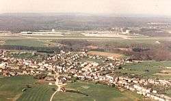
Sandweiler and Findel | ||
| ||
|
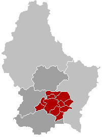
Map of Luxembourg with Sandweiler highlighted in orange, and the canton in dark red | ||
| Coordinates: 49°37′00″N 6°13′00″E / 49.6167°N 6.2167°ECoordinates: 49°37′00″N 6°13′00″E / 49.6167°N 6.2167°E | ||
| Country |
| |
| Canton | Luxembourg | |
| Government | ||
| • Mayor | Simone Massard-Stitz | |
| Area | ||
| • Total | 7.73 km2 (2.98 sq mi) | |
| Area rank | 101st of 105 | |
| Highest elevation | 383 m (1,257 ft) | |
| • Rank | 68th of 105 | |
| Lowest elevation | 294 m (965 ft) | |
| • Rank | 94th of 105 | |
| Population (2014) | ||
| • Total | 3,405 | |
| • Rank | 43rd of 105 | |
| • Density | 440/km2 (1,100/sq mi) | |
| • Density rank | 17th of 105 | |
| Time zone | CET (UTC+1) | |
| • Summer (DST) | CEST (UTC+2) | |
| LAU 2 | LU00011006 | |
| Website | sandweiler.lu | |
Sandweiler is a commune and town in southern Luxembourg. It is located 5 kilometres (3.1 mi) east of Luxembourg City.
As of 2005, the town of Sandweiler, which lies in the south-west of the commune, has a population of 3,450. Other settlements within the commune include Findel.
The commune is dominated by Luxembourg-Findel International Airport, Luxembourg's only international airport and the fifth-busiest cargo airport in Europe, which lies to the north and west of the town of Sandweiler. It is also home to the Sandweiler German war cemetery. The commune is surrounded by forests.
Traffic is a big problem for the commune, since it is on a main road with Germany, and many commuters cause traffic jams in the morning. The traffic problems have been made worse by the provision of bus lanes, which have reduced the available space for automobiles.
Economy
Two airline companies, Luxair and Cargolux, have their head offices on the grounds of Luxembourg Findel Airport in Sandweiler.[1][2][3]
DuPont Teijin Films has its headquarters in Sandweiler commune.
References
- ↑ "Luxair S.A. Notes to the accounts." paperJam. Retrieved on 2 November 2009.
- ↑ "Directory: World Airlines". Flight International. 2007-04-03. p. 108.
- ↑ "Network & Offices Luxembourg." Cargolux. Retrieved on 15 May 2010.
External links
-
 Media related to Sandweiler at Wikimedia Commons
 - (French) Commune of Sandweiler official website
 |
Niederanven |  | ||
| Luxembourg City | |
Schuttrange | ||
| ||||
| | ||||
| Hesperange | Contern |


