Weiler-la-Tour
| Weiler-la-Tour Weiler zum Tuerm | ||
|---|---|---|
| Commune | ||
|
Weiler-la-Tour church | ||
| ||
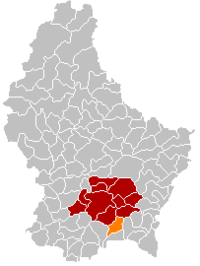 Map of Luxembourg with Weiler-la-Tour highlighted in orange, and the canton in dark red | ||
| Coordinates: 49°32′35″N 6°12′00″E / 49.5431°N 6.2°ECoordinates: 49°32′35″N 6°12′00″E / 49.5431°N 6.2°E | ||
| Country |
| |
| Canton | Luxembourg | |
| Government | ||
| • Mayor | Cécile Hemmen | |
| Area | ||
| • Total | 17.07 km2 (6.59 sq mi) | |
| Area rank | 71st of 105 | |
| Highest elevation | 329 m (1,079 ft) | |
| • Rank | 95th of 105 | |
| Lowest elevation | 243 m (797 ft) | |
| • Rank | 55th of 105 | |
| Population (2014) | ||
| • Total | 2,120 | |
| • Rank | 62nd of 105 | |
| • Density | 120/km2 (320/sq mi) | |
| • Density rank | 55th of 105 | |
| Time zone | CET (UTC+1) | |
| • Summer (DST) | CEST (UTC+2) | |
| LAU 2 | LU00011011 | |
| Website | weiler-la-tour.lu | |


Weiler-la-Tour (Luxembourgish: Weiler zum Tuerm, German: Weiler zum Turm) is a commune and small town in southern Luxembourg. It is located south-east of Luxembourg City. The commune's administrative centre is Hassel.
As of 2005, the town of Weiler-la-Tour, which lies in the south of the commune, has a population of 477. Other towns within the commune include Hassel and Syren.
External links
-
 Media related to Weiler-la-Tour at Wikimedia Commons
 |
Contern | | ||
| Hesperange Roeser |
|
Dalheim (G) | ||
| ||||
| | ||||
| Frisange |
 | ||
This article is issued from Wikipedia - version of the 12/1/2016. The text is available under the Creative Commons Attribution/Share Alike but additional terms may apply for the media files.