U.S. Route 340 in Maryland
| ||||
|---|---|---|---|---|
|
U.S. Route 340 highlighted in red | ||||
| Route information | ||||
| Maintained by MDSHA | ||||
| Length: | 17.01 mi[1] (27.37 km) | |||
| Existed: | 1926 – present | |||
| Tourist routes: |
| |||
| Major junctions | ||||
| West end: |
| |||
|
| ||||
| East end: |
| |||
| Location | ||||
| Counties: | Washington, Frederick | |||
| Highway system | ||||
| ||||

_map.png)
U.S. Route 340 (US 340) is a part of the U.S. Highway System that runs from Greenville, Virginia to Frederick, Maryland. In Maryland, the U.S. highway runs 17.01 miles (27.37 km) from the Virginia state line at the Potomac River at Sandy Hook east to its northern terminus at US 15 and US 40 in Frederick. US 340, which is known for most of its length as Jefferson National Pike, connects Frederick with the communities of Jefferson, Brunswick, and Knoxville in the southern part of the Middletown Valley of western Frederick County and Weverton in far southern Washington County. The U.S. highway also links Frederick with Harpers Ferry and Charles Town in the Eastern Panhandle of West Virginia. US 340 is a part of the National Highway System for its entire length in Maryland.[2]
US 340 was one of the original state roads designated by the Maryland State Roads Commission. The state road was constructed from Frederick to Knoxville in the early 1910s and completed to Harpers Ferry in 1919. The highway was designated Maryland's portion of US 340 in 1926. US 340 originally crossed the Potomac River at Harpers Ferry; however, the U.S. highway's bridge was destroyed by a flood in 1936. The modern US 340 Bridge was constructed at Sandy Hook between 1940 and 1947, with a long interruption due to World War II. The U.S. highway's freeway between Weverton and Frederick was constructed in the 1960s. Old sections of US 340 became part of Maryland Route 180 (MD 180).
Route description

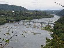
US 340 enters Maryland at the Potomac Water Gap just south of the confluence of the Potomac River and the Shenandoah River at Harpers Ferry. The Potomac Water Gap is where the Potomac River passes between two sets of ridges. The first set of ridges is Elk Ridge to the north, also known as Maryland Heights, and Blue Ridge Mountain, which forms the border between West Virginia and Virginia, to the south. The second set of ridges is South Mountain in Maryland and Short Hill Mountain in Virginia. US 340 passes along the northern edge of Blue Ridge Mountain then passes through the northwestern corner of Loudoun County, Virginia before crossing the Potomac River at an angle, running southwest–northeast on a two-lane steel continuous deck truss bridge at the community of Sandy Hook. On the Maryland side, the bridge also crosses the Chesapeake and Ohio Canal, CSX's Cumberland Subdivision, and Sandy Hook Road, the original alignment of US 340.[1][3]
Just north of the bridge, US 340 is named Jefferson Pike and widens to a two-lane divided highway that intersects Valley Road and Keep Tryst Road; the sweeping ramp from northbound US 340 to Keep Tryst Road is the old alignment of US 340. Beyond the intersection, the U.S. highway curves to the east, expands to four lanes, and meets the southern end of MD 67 (Rohrersville Road) at a trumpet interchange in Weverton. After the highway crosses Israel Creek, the eastbound direction of US 340 has a right-in/right-out intersection with the eastern end of Keep Tryst Road. The U.S. highway becomes a freeway with a speed limit of 65 miles per hour (105 km/h) that parallels the C&O Canal and the railroad line, now part of the Metropolitan Subdivision, between the river and the southern end of South Mountain into Frederick County, where US 340's name changes to Jefferson National Pike and the highway meets the western end of MD 180 (Jefferson Pike) at a partial interchange near Knoxville. There is no access from westbound US 340 to eastbound MD 180 or from westbound MD 180 to eastbound US 340.[1][3]
US 340 veers away from the Potomac River and passes through farmland of the Catoctin Valley, paralleled by its old alignment, MD 180, at a distance to the south. The U.S. highway meets MD 17 (Burkittsville Road) at a diamond interchange near Rosemont and crosses Little Catoctin Creek. East of Petersville, US 340 has a diamond interchange with MD 180 and crosses Catoctin Creek. On the western edge of Jefferson, westbound US 340 receives a ramp from MD 180. Full access to Jefferson is provided by a diamond interchange with Lander Road. The U.S. highway passes through a wide gap in Catoctin Mountain and has a partial interchange with US 15 (Catoctin Mountain Highway), which heads south toward Point of Rocks. US 15 and US 340 join in a concurrency that lasts through US 340's eastern terminus in Frederick. Access from northbound US 15 to westbound US 340 and from eastbound US 340 to southbound US 15 is provided through performing a U-turn at the next interchange, a diamond interchange with Mt. Zion Road.[1][3]
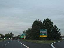
US 340 and US 15 cross over Ballenger Creek and the freeway's speed limit drops to 55 miles per hour (89 km/h) before the highways approach a series of three interchanges on the southwest side of Frederick. The highway's partial interchange with I-70 (Eisenhower Memorial Highway) features ramps from eastbound I-70 to both directions of US 340, a ramp from westbound I-70 to westbound US 340, and a ramp from eastbound US 340 to eastbound I-70 and access to southbound I-270 just to the east. Immediately to the northeast, US 15 and US 340 have a folded diamond interchange with MD 180 and Ballenger Creek Pike, which meets MD 180 just south of the interchange, that features four loop ramps. US 340 reaches its eastern terminus at the third interchange, which is a partial cloverleaf interchange with the Frederick Freeway. The first ramp from eastbound US 340 provides access to westbound I-70; the second ramp leads to the northbound Frederick Freeway (US 40), onto which US 15 exits. The ramps from westbound US 340 provide full access to I-70, I-270, US 15, and US 40. The roadway continues northeast as Jefferson Street, which reduces to a two-lane undivided street that heads toward an intersection with MD 144 (South Street eastbound and Patrick Street westbound) just west of downtown Frederick. The portion of Jefferson Street between the overpass of US 40 and just west of Jefferson Street's intersection with Pearl Street is unsigned US 15B.[1][3]
History
US 340 follows the corridor of the old road from Frederick to Harpers Ferry, part of which was organized as the Frederick and Jefferson Turnpike between the two towns.[4] This highway became one of the original state roads marked for improvement by the Maryland State Roads Commission in 1909.[5] The commission purchased the right-of-way of the turnpike in 1911 and resurfaced the Frederick–Jefferson highway with a 14-foot (4.3 m) wide macadam surface in 1915.[6][7] The segments from Jefferson to Petersville and from Petersville to Knoxville were placed under construction in 1911 and completed as a 14-foot (4.3 m) macadam road in 1912.[7][8] The highway from Knoxville to the Potomac River opposite Harpers Ferry was completed as a concrete road in 1919.[9] The Frederick–Knoxville highway was widened to 17-foot (5.2 m) in width around 1926 and became part of US 340 in 1927.[10][11] US 340 was widened again, this time to 20 feet (6.1 m) between Frederick and Knoxville, by 1934.[12]
US 340 was widened and resurfaced with bituminous concrete from Knoxville to the approach to new bridge at Sandy Hook in 1948.[13][14] In conjunction with the construction of the Frederick Freeway, US 340's cloverleaf interchange with US 40 was built in 1954 and 1955.[15][16] Jefferson Street in Frederick was widened in 1956.[16] When US 40 was moved from Patrick Street to the Frederick Freeway in 1959, US 340's eastern terminus was moved from Patrick Street west to the new interchange.[17] Construction on the US 340 freeway began when the highway's bridge across Catoctin Creek was built in 1961.[18] This bridge came into use in 1964 when the freeway segment between the MD 180 interchange east of Petersville and the ramp from MD 180 west of Jefferson was opened, replacing the curvaceous old alignment at Catoctin Creek. The present alignment of US 340 opened as a four-lane divided highway from the Valley Road / Keep Tryst Road intersection in Sandy Hook east to Weverton also opened that year.[19] The portion of the freeway between Weverton and MD 180 east of Petersville was under construction in 1964 and completed in 1965.[19][20] MD 180 was assigned to old US 340 from Sandy Hook to west of Jefferson in 1965.[20]
Construction on the US 340 freeway east toward Frederick began in 1966.[21] The freeway east to the current Point of Rocks – Jefferson segment of US 15 was completed in 1967; however, the US 15 interchange would not become operational until the new US 15 was completed and the two U.S. highways became concurrent in 1970.[22][23] US 340's interchanges with I-70 and MD 180 were completed in 1968 and the portion of the freeway from the US 15 interchange east to MD 180 opened in 1969.[24][25] At that time, MD 180 was extended east over the old Jefferson–Frederick section of US 340.[25] US 340's interchanges with MD 67 in Weverton and Mt. Zion Road near Frederick opened in 1971 and 1972, respectively.[26][27] Several ramps were added to improve access between US 340 and I-70 in 1997, including a pair of ramps from eastbound I-70 to US 340 and the connection from northbound US 340 to westbound I-70 at US 340's northern terminus.[28] The interchange at US 340's northern terminus was converted from a cloverleaf interchange to a partial cloverleaf interchange with traffic signals in 2004.[29]
Sandy Hook Bridge
US 340 originally followed Sandy Hook Road south and west from what is now Keep Tryst Road in Sandy Hook and paralleled the Potomac River west to Maryland Heights directly across the river from downtown Harpers Ferry. There, the U.S. highway crossed the river on a converted railroad bridge immediately upstream from the confluence of the Potomac and Shenandoah rivers and downstream from the two railroad bridges—one for CSX's Cumberland Subdivision on the north and the other for the Shenandoah Subdivision—that presently cross the river at the site. After the highway bridge was destroyed in the March 1936 flood, a wooden floor was placed on the Shenandoah Subdivision bridge for that bridge to temporarily serve both rail and automobile traffic.[30][31] Later in 1936, Maryland and West Virginia acquired the right-of-way of the destroyed toll bridge owned by the Harpers Ferry and Potomac Bridge Company by eminent domain with an aim to build a new bridge at the site.[32]
In August 1939, Maryland, West Virginia, and Virginia decided to instead embark on a tri-state road and bridge program to replace the destroyed bridge.[33] Plans for bridges across the Potomac and Shenandoah rivers and connecting highways were completed in August 1940.[34][35] The new bridge across the Potomac river was to be placed at Sandy Hook to exploit the scenic views of the Potomac Water Gap.[36] However, in December 1940, construction was delayed and plans needed to be modified to eliminate a sharp turn at the Virginia landing of the bridge.[37] Despite a late request from the Virginia State Highway Department to move the Potomac River crossing upstream in June 1941, the concrete substructure of the Sandy Hook bridge was started in autumn 1941.[38][39][40] The substructure was completed in March 1943.[41] A request for bids for the Sandy Hook bridge's steel superstructure was advertised in November 1941.[42] However, with the U.S. entering into World War II the following month, the construction of the superstructure of the bridge would be delayed until after the war due to the unavailability of steel.[38][43]
The Maryland State Roads Commission advertised for bids for the Sandy Hook bridge's superstructure in December 1945.[44] Construction started shortly thereafter and the superstructure was completed in January 1947.[41][45] The Maryland and Virginia approach roads were completed later in 1947 and the bridge officially opened October 19, 1947.[13][46] Although the residents of Harpers Ferry lobbied for an on-site replacement of the bridge over the Shenandoah River at Harpers Ferry so US 340 would continue to pass directly through the historic town, the West Virginia State Road Commission completed a new roadway and a new Shenandoah River crossing along US 340's present alignment in 1949.[47][48] US 340 was rerouted onto its present course over the two new bridges by 1950.[49]
Future
An interchange has been planned for the future section of Monocacy Boulevard within the planned Jefferson Tech Park in Frederick.[50][51]
Junction list
| County | Location | mi [1] | km | Exit | Destinations | Notes |
|---|---|---|---|---|---|---|
| Washington | Sandy Hook | 0.00 | 0.00 | Southern terminus; Virginia state line at Potomac River | ||
| 0.74 | 1.19 | Valley Road north / Keep Tryst Road east | At-grade intersection | |||
| Weverton | 1.56 | 2.51 | Trumpet interchange | |||
| 1.82 | 2.93 | Keep Tryst Road west | Right-in/right-out intersection with eastbound US 340 | |||
| Frederick | Knoxville | 2.53 | 4.07 | Eastbound exit, westbound entrance | ||
| Rosemont | 4.39 | 7.07 | 2 | |||
| Petersville | 7.77 | 12.50 | 4 | |||
| Jefferson | 10.57 | 17.01 | 8 | Lander Road – Jefferson | ||
| 12.30 | 19.79 | West end of concurrency with US 15; westbound exit, eastbound entrance | ||||
| | 13.92 | 22.40 | Mt. Zion Road | |||
| Frederick | 16.38 | 26.36 | 10 | I-70 Exit 52; no exit westbound | ||
| 16.62 | 26.75 | 11 | ||||
| 17.01 | 27.37 | 12 | Northern terminus of US 340; partial cloverleaf interchange; split into exits 12A (I-70) and 12B (US 15 / US 40) eastbound | |||
| 1.000 mi = 1.609 km; 1.000 km = 0.621 mi | ||||||
See also
 Maryland Roads portal
References
- 1 2 3 4 5 6 Highway Information Services Division (December 31, 2013). Highway Location Reference. Maryland State Highway Administration. Retrieved 2011-03-23.
- Washington County (PDF)
- Frederick County (PDF)
- ↑ National Highway System: Maryland (PDF) (Map). Federal Highway Administration. August 2003. Retrieved 2011-03-28.
- 1 2 3 4 Google (2011-03-23). "U.S. Route 340 in Maryland" (Map). Google Maps. Google. Retrieved 2011-03-23.
- ↑ Clark, William Bullock (1899). Report on the Highways of Maryland. Baltimore: Maryland Geological Survey. p. 232. Retrieved 2011-03-28.
- ↑ Maryland Geological Survey (1910). Map of Maryland (Map). Baltimore: Maryland Geological Survey.
- ↑ Shoemaker, S.M.; Clark, William Bullock; Lloyd, Charles B. (May 1912). Annual Reports of the State Roads Commission of Maryland (1908–1911 ed.). Baltimore: Maryland State Roads Commission. p. 34. Retrieved 2011-03-28.
- 1 2 Weller, O.E.; Parran, Thomas; Miller, W.B.; Perry, John M.; Ramsay, Andrew; Smith, J. Frank (May 1916). Annual Reports of the State Roads Commission of Maryland (1912–1915 ed.). Baltimore: Maryland State Roads Commission. p. 110. Retrieved 2011-03-28.
- ↑ Maryland Geological Survey (1911). Map of Maryland: Showing State Road System and State Aid Roads Completed or Under Construction December 31, 1911 (Map). Baltimore: Maryland Geological Survey.
- ↑ Zouck, Frank H.; Uhl, G. Clinton; Mudd, John F. (January 1920). Annual Reports of the State Roads Commission of Maryland (1916–1919 ed.). Baltimore: Maryland State Roads Commission. p. 19. Retrieved 2011-03-28.
- ↑ Mackall, John N.; Darnall, R. Bennett; Brown, W.W. (January 1927). Annual Reports of the State Roads Commission of Maryland (1924–1926 ed.). Baltimore: Maryland State Roads Commission. p. 55. Retrieved 2011-03-28.
- ↑ Maryland Geological Survey (1927). Map of Maryland: Showing State Road System and State Aid Roads (Map). Baltimore: Maryland Geological Survey.
- ↑ Byron, William D.; Lacy, Robert (December 28, 1934). Report of the State Roads Commission of Maryland (1931–1934 ed.). Baltimore: Maryland State Roads Commission. p. 32. Retrieved 2011-03-28.
- 1 2 Reindollar, Robert M.; George, Joseph M.; McCain, Russell H. (February 15, 1949). Report of the State Roads Commission of Maryland (1947–1948 ed.). Baltimore: Maryland State Roads Commission. pp. 136, 137. Retrieved 2011-03-28.
- ↑ Reindollar, Robert M.; George, Joseph M.; McCain, Russell H. (December 20, 1950). Report of the State Roads Commission of Maryland (1949–1950 ed.). Baltimore: Maryland State Roads Commission. pp. 173, 178. Retrieved 2011-03-28.
- ↑ Maryland State Roads Commission (1955). Maryland: Official Highway Map (Map). Baltimore: Maryland State Roads Commission.
- 1 2 Bonnell, Robert O.; Bennett, Edgar T.; McMullen, John J. (November 2, 1956). Report of the State Roads Commission of Maryland (1955–1956 ed.). Baltimore: Maryland State Roads Commission. p. 205. Retrieved 2011-03-28.
- ↑ Maryland State Roads Commission (1958). Maryland: Official Highway Map (Map). Baltimore: Maryland State Roads Commission.
- ↑ "NBI Structure Number: 100000100112010". National Bridge Inventory. Retrieved 2011-03-28.
- 1 2 Maryland State Roads Commission (1964). Maryland: Official Highway Map (Map). Baltimore: Maryland State Roads Commission.
- 1 2 Maryland State Roads Commission (1965). Maryland: Official Highway Map (Map). Baltimore: Maryland State Roads Commission.
- ↑ Maryland State Roads Commission (1966). Maryland: Official Highway Map (Map). Baltimore: Maryland State Roads Commission.
- ↑ Maryland State Roads Commission (1967). Maryland: Official Highway Map (Map). Baltimore: Maryland State Roads Commission.
- ↑ Maryland State Roads Commission (1970). Maryland: Official Highway Map (Map). Baltimore: Maryland State Roads Commission.
- ↑ Maryland State Roads Commission (1968). Maryland: Official Highway Map (Map). Baltimore: Maryland State Roads Commission.
- 1 2 Maryland State Roads Commission (1969). Maryland: Official Highway Map (Map). Baltimore: Maryland State Roads Commission.
- ↑ Maryland State Roads Commission (1971). Maryland: Official Highway Map (Map). Baltimore: Maryland State Roads Commission.
- ↑ Maryland State Highway Administration (1972). Maryland: Official Highway Map (Map). Baltimore: Maryland State Highway Administration.
- ↑ Maryland State Highway Administration (1997). Maryland: Official Highway Map (Map). Baltimore: Maryland State Highway Administration.
- ↑ Highway Information Services Division (December 31, 2004). Highway Location Reference. Maryland State Highway Administration. Retrieved 2011-03-28.
- Frederick County (PDF)
- ↑ Tabler, H.E.; Wilkinson, C. Nice; Luthardt, Frank F. (December 4, 1936). Report of the State Roads Commission of Maryland (1935–1936 ed.). Baltimore: Maryland State Roads Commission. p. 53. Retrieved 2011-03-28.
- ↑ "To Restore Traffic Over Potomac River". The Baltimore Sun. Baltimore: Tribune Company. 1936-03-28. p. 22.
- ↑ "Roads Board is Given Right to Buy Bridge". The Baltimore Sun. Baltimore: Tribune Company. 1936-06-30. p. 22.
- ↑ "Tri-State Traffic Plans Advanced". The Baltimore Sun. Baltimore: Tribune Company. 1939-08-02. p. 9.
- ↑ Whitman, Ezra B.; Webb, P. Watson; Thomas, W. Frank (March 15, 1941). Report of the State Roads Commission of Maryland (1939–1940 ed.). Baltimore: Maryland State Roads Commission. pp. 57–58. Retrieved 2011-03-28.
- ↑ "Sandy Hook Bridge". Farmers Advocate. Charles Town, WV: Jefferson Publishing Company. 1940-08-30. p. 1. Retrieved 2011-04-05.
- ↑ "State Plans New Harpers Ferry Bridge". The Baltimore Sun. Baltimore: Tribune Company. 1940-10-02. p. 24.
- ↑ "Building of Sandy Hook Bridge to Be Delayed". The Baltimore Sun. Baltimore: Tribune Company. 1940-12-11. p. 9.
- 1 2 Whitman, Ezra B.; Webb, P. Watson; Thomas, W. Frank (March 15, 1943). Report of the State Roads Commission of Maryland (1941–1942 ed.). Baltimore: Maryland State Roads Commission. p. 101. Retrieved 2011-03-28.
- ↑ "Sandy Hook Bridge Change is Sought". The Baltimore Sun. Baltimore: Tribune Company. 1941-06-14. p. 22.
- ↑ "One Sandy Hook Span Bid Received". The Baltimore Sun. Baltimore: Tribune Company. 1941-09-10. p. 11.
- 1 2 Reindollar, Robert M.; Webb, P. Watson; McCain, Russell H. (February 1, 1947). Report of the State Roads Commission of Maryland (1945–1946 ed.). Baltimore: Maryland State Roads Commission. pp. 61, 108. Retrieved 2011-03-28.
- ↑ "Sandy Hook Bridge Bids are Invited". The Baltimore Sun. Baltimore: Tribune Company. 1941-11-27. p. 22.
- ↑ "Sandy Hook Bridge Delay is Forecast". The Baltimore Sun. Baltimore: Tribune Company. 1942-01-27. p. 23.
- ↑ "Bethlehem Steel Co. Will Finish Bridge". Farmers Advocate. Charles Town, WV: Jefferson Publishing Company. 1945-12-28. p. 1. Retrieved 2011-04-05.
- ↑ "Sandy Hook Bridge is Completed". Farmers Advocate. Charles Town, WV: Jefferson Publishing Company. 1947-01-31. p. 4. Retrieved 2011-04-05.
- ↑ "Lane Opens New Bridge". The Baltimore Sun. Baltimore: Tribune Company. 1947-10-19. p. 27.
- ↑ "Harpers Ferry Fears Loss of Present Tourist Trade". Farmers Advocate. Charles Town, WV: Jefferson Publishing Company. 1947-09-26. p. 8. Retrieved 2011-04-05.
- ↑ "'March of Progress' Bridge to Isolate Harpers Ferry". The Baltimore Sun. Baltimore: Tribune Company. 1949-09-28. p. 34.
- ↑ Maryland State Roads Commission (1950). Maryland: Official Highway Map (Map). Baltimore: Maryland State Roads Commission.
- ↑ "Major Highway Improvements". National Capital Region Transportation Planning Board. July 18, 2012. Retrieved 20 Sep 2012.
- ↑ "County Commissioners Move Forward with Tech Park" (PDF). July 20, 2012. Retrieved 20 Sep 2012.
External links
| Previous state: Virginia |
Maryland | Next state: Terminus |