Brunswick, Maryland
| Brunswick, Maryland | ||
|---|---|---|
| City | ||
| City of Brunswick | ||
|
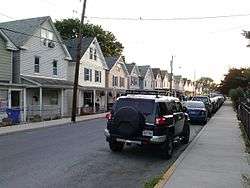
A row of Brunswick houses in 2014 | ||
| ||
| Motto: Big Town. Small City. | ||
 Location of Brunswick, Maryland | ||
| Coordinates: 39°18′50″N 77°37′36″W / 39.31389°N 77.62667°WCoordinates: 39°18′50″N 77°37′36″W / 39.31389°N 77.62667°W | ||
| Country |
| |
| State |
| |
| County |
| |
| Government | ||
| • Mayor | Jeff Snoots | |
| Area[1] | ||
| • Total | 3.71 sq mi (9.61 km2) | |
| • Land | 3.27 sq mi (8.47 km2) | |
| • Water | 0.44 sq mi (1.14 km2) | |
| Elevation | 295 ft (90 m) | |
| Population (2010)[2] | ||
| • Total | 5,870 | |
| • Estimate (2012[3]) | 6,031 | |
| • Density | 1,795.1/sq mi (693.1/km2) | |
| Time zone | Eastern (EST) (UTC-5) | |
| • Summer (DST) | EDT (UTC-4) | |
| ZIP code | 21716 | |
| Area code(s) | 301 | |
| FIPS code | 24-10900 | |
| GNIS feature ID | 0595202 | |
Brunswick is a city in Frederick County, Maryland, United States. The population was 5,870 at the 2010 census.
History
The area now known as Brunswick was originally home to the Susquehanna Indians. In 1728 the first settlement was built, and the region became known as Eel Town, because the natives would fish for eel in the Potomac River. A grant to the land was then given to John Hawkins by George II of Great Britain on August 10, 1753. The grant had the name "Hawkins Merry-Peep-o-Day".[4]
The land was sold and Leonard Smith platted it in 1787 with the name of “Berlin,” as many Germans settled in the area. The name “Berlin,” however, could not be used for mail as there was already a Berlin on the Eastern Shore of Maryland, so the post office changed the name to "Barry." The town continued to grow and was incorporated April 18, 1890 with the name “Brunswick.”
Established along the now-defunct Chesapeake and Ohio Canal, the city became a hub for the Baltimore and Ohio Railroad, which built a six-mile-long rail yard along the Potomac from 1891 to 1912, boosting the population to over 5,000, and making Brunswick virtually a company town. The railroad reduced its yard operations in the 1950s.
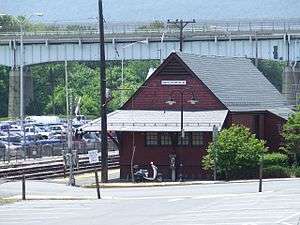
Today Brunswick is home to a commuter rail station serving Washington, D.C.. It is home of the Brunswick Railroad Museum that shows the history of the city and is home of a large model railroad showing why the city's location was important to the railroad.
Tourism
The largest city-wide event is "Railroad Days" on the first weekend in October. Other events year round include the Veterans Day Parade on the first Sunday of November, the Wine and Chocolate Walk in September, Farmers' Market, Arts In The Parks, Little League opening day, and other city and museum events.
The city markets its historic downtown, the railroad museum, and its access to the C&O Canal and Potomac River. There are antique stores, restaurants, a brewpub, a yoga studio, a martial arts studio, a beauty salon, a bakery, and a hardware store in the downtown area. There are live music performances many nights of the week at Beans in the Belfry, a café in a converted Lutheran church.
Geography
Brunswick is at 39°18′50″N 77°37′36″W / 39.31389°N 77.62667°W (39.313908, -77.626732).[5]
According to the United States Census Bureau, the city has a total area of 3.71 square miles (9.61 km2), of which, 3.27 square miles (8.47 km2) is land and 0.44 square miles (1.14 km2) is water.[1]
Demographics
| Historical population | |||
|---|---|---|---|
| Census | Pop. | %± | |
| 1900 | 2,471 | — | |
| 1910 | 3,721 | 50.6% | |
| 1920 | 3,905 | 4.9% | |
| 1930 | 3,671 | −6.0% | |
| 1940 | 3,856 | 5.0% | |
| 1950 | 3,752 | −2.7% | |
| 1960 | 3,555 | −5.3% | |
| 1970 | 3,566 | 0.3% | |
| 1980 | 4,572 | 28.2% | |
| 1990 | 5,117 | 11.9% | |
| 2000 | 4,894 | −4.4% | |
| 2010 | 5,870 | 19.9% | |
| Est. 2015 | 6,116 | [6] | 4.2% |
| Decennial US Census | |||
2010 census
As of the census[2] of 2010, there were 5,870 people, 2,155 households, and 1,515 families residing in the city. The population density was 1,795.1 inhabitants per square mile (693.1/km2). There were 2,330 housing units at an average density of 712.5 per square mile (275.1/km2). The racial makeup was 86.3% White, 7.5% African American, 0.2% Native American, 1.7% Asian, 1.2% from other races, and 3.2% from two or more races. Hispanic or Latino of any race were 4.9% of the population.
There were 2,155 households of which 38.5% had children under the age of 18 living with them, 51.6% were married couples living together, 13.7% had a female householder with no husband present, 5.0% had a male householder with no wife present, and 29.7% were non-families. 23.2% of all households were made up of individuals and 8.8% had someone living alone who was 65 years of age or older. The average household size was 2.72 and the average family size was 3.22.
The median age in the city was 36.9 years. 27.1% of residents were under the age of 18; 7.9% were between the ages of 18 and 24; 28% were from 25 to 44; 27.3% were from 45 to 64; and 9.8% were 65 years of age or older. The gender makeup was 49.1% male and 50.9% female.
2000 census
As of the census[7] of 2000, there were 4,894 people, 1,866 households, and 1,306 families residing in the city. The population density was 2,324.3 people per square mile (895.5/km²). There were 1,957 housing units at an average density of 929.4 per square mile (358.1/km²). The racial makeup of the city was 92.09% White, 5.31% African American, 0.25% Native American, 0.45% Asian, 0.04% Pacific Islander, 0.18% from other races, and 1.68% from two or more races. Hispanic or Latino of any race were 0.96% of the population.
There were 1,866 households out of which 36.3% had children under the age of 18 living with them, 50.4% were married couples living together, 14.4% had a female householder with no husband present, and 30.0% were non-families. 23.7% of all households were made up of individuals and 10.6% had someone living alone who was 65 years of age or older. The average household size was 2.62 and the average family size was 3.11.
In the city the population was spread out with 27.3% under the age of 18, 8.4% from 18 to 24, 33.1% from 25 to 44, 20.2% from 45 to 64, and 11.0% who were 65 years of age or older. The median age was 35 years. For every 100 females there were 93.2 males. For every 100 females age 18 and over, there were 89.5 males.
The median income for a household in the city was $46,513, and the median income for a family was $53,232. Males had a median income of $36,304 versus $25,017 for females. The per capita income was $20,685. About 2.5% of families and 3.7% of the population were below the poverty line, including 4.8% of those under age 18 and 3.5% of those age 65 or over.
Climate data
| Climate data for Brunswick, Maryland | |||||||||||||
|---|---|---|---|---|---|---|---|---|---|---|---|---|---|
| Month | Jan | Feb | Mar | Apr | May | Jun | Jul | Aug | Sep | Oct | Nov | Dec | Year |
| Record high °F (°C) | 78 (26) |
81 (27) |
89 (32) |
94 (34) |
99 (37) |
107 (42) |
109 (43) |
108 (42) |
108 (42) |
98 (37) |
86 (30) |
79 (26) |
109 (43) |
| Average high °F (°C) | 41 (5) |
45 (7) |
53 (12) |
64 (18) |
73 (23) |
82 (28) |
87 (31) |
86 (30) |
78 (26) |
67 (19) |
56 (13) |
45 (7) |
64.8 (18.3) |
| Average low °F (°C) | 21 (−6) |
23 (−5) |
30 (−1) |
40 (4) |
49 (9) |
59 (15) |
63 (17) |
62 (17) |
54 (12) |
42 (6) |
33 (1) |
25 (−4) |
41.8 (5.4) |
| Record low °F (°C) | −11 (−24) |
−8 (−22) |
7 (−14) |
20 (−7) |
29 (−2) |
39 (4) |
46 (8) |
41 (5) |
32 (0) |
21 (−6) |
8 (−13) |
−5 (−21) |
−11 (−24) |
| Average precipitation inches (mm) | 3.29 (83.6) |
2.47 (62.7) |
3.64 (92.5) |
3.48 (88.4) |
4.45 (113) |
4.21 (106.9) |
3.68 (93.5) |
3.82 (97) |
4.16 (105.7) |
3.38 (85.9) |
3.52 (89.4) |
3.11 (79) |
43.21 (1,097.6) |
| Source: The Weather Channel[8] | |||||||||||||
References
- 1 2 "US Gazetteer files 2010". United States Census Bureau. Archived from the original on 2012-07-14. Retrieved 2013-01-25.
- 1 2 "American FactFinder". United States Census Bureau. Retrieved 2013-01-25.
- ↑ "Population Estimates". United States Census Bureau. Archived from the original on 2013-06-17. Retrieved 2013-06-26.
- ↑ Hahn, Thomas F. Swiftwater (1993). Towpath Guide to the C&O Canal: Georgetown Tidelock to Cumberland, Revised Combined Edition. Shepherdstown, WV: American Canal and Transportation Center. ISBN 0-933788-66-5. P.91
- ↑ "US Gazetteer files: 2010, 2000, and 1990". United States Census Bureau. 2011-02-12. Retrieved 2011-04-23.
- ↑ "Annual Estimates of the Resident Population for Incorporated Places: April 1, 2010 to July 1, 2015". Retrieved July 2, 2016.
- ↑ "American FactFinder". United States Census Bureau. Archived from the original on 2013-09-11. Retrieved 2008-01-31.
- ↑ "Average Weather for Brunswick, MD - Temperature and Precipitation". The Weather Channel. Retrieved July 15, 2013.
External links
| Wikimedia Commons has media related to Brunswick, Maryland. |
| Wikivoyage has a travel guide for Brunswick (Maryland). |
- Official website
- Brunswick Main Street
- Brunswick Maryland Flickr Group
- Brunswick Photographer's Guild
- Brunswick Heritage Museum
- Brunswick, Maryland at DMOZ
Municipalities and communities of Frederick County, Maryland, United States | ||
|---|---|---|
| Cities | 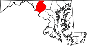 | |
| Towns | ||
| Village | ||
| CDPs | ||
| Other communities |
| |
| Footnotes | ‡This populated place also has portions in an adjacent county or counties | |
| Principal cities |
| |||||||||||
|---|---|---|---|---|---|---|---|---|---|---|---|---|
| Counties and county equivalents* |
| |||||||||||
The District of Columbia itself, and Virginia's incorporated cities, are county equivalents. Virginia's incorporated cities are listed under their surrounding county. The incorporated cities bordering more than one county (Alexandria, Falls Church and Fredericksburg) are listed under the county they were part of before incorporation as a city. | ||||||||||||

