Sant Antoni de Portmany (Municipality)
| Sant Antoni de Portmany | ||
|---|---|---|
| Town & Municipality | ||
|
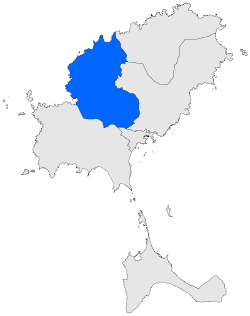
The environment of Sant Antoni de Portmany | ||
| ||
 Municipal location | ||
 Sant Antoni de Portmany Location of the Town of Sant Antoni de Portmany | ||
| Coordinates: 38°58′21″N 1°18′21″E / 38.97250°N 1.30583°E | ||
| Country |
| |
| Region | Balearic Islands | |
| Area | ||
| • Total | 48.96 sq mi (126.80 km2) | |
| Population | ||
| • Total | 21,852 | |
| Time zone | CET (UTC+1) | |
| • Summer (DST) | CEST (UTC+2) | |
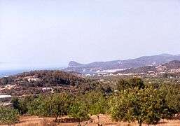

Sant Antoni de Portmany (Catalan pronunciation: [ˈsant ənˈtɔni ðə purˈmaɲ], Spanish: San Antonio Abad) is a municipality on the North central coast of Ibiza.[1][2][3] The municipality is situated on Sant Antoni Bay on the north west seaboard of the island, part of the Spanish autonomous community of the Balearic Islands.The total number of inhabitants in the municipality (2009) is 21,852.
The municipality encompasses the following towns and villages:
| Town/village | Population (2008) |
|---|---|
| Sant Antoni de Portmany | |
| San Rafael de Sa Creu | 2047 |
| Sant Mateu d’Albarca | |
| Buscastell | |
| Santa Agnès de Corona |
Local Government
The current Mayor of Sant Antoni de Portmany is Josefa Gutiérrez Costa (Partit Popular (Espanya)) (2007)
See also
- The Town of Sant Antoni de Portmany
External links
- The Town Hall website(Catalan)
- Local government website
- Statistical Institute information of the Balearic Islands
References
- ↑ "579 Regional Map, Spain, Islas Baleares. Pub:Michelin Editions des Voyages, 2004, ISBN 2-06-710098-X
- ↑ Title: Mapa Topográfico Nacional de España - 798 Ibiza/Eivissa. Published: ING. Date of issue: 2006 Edition. :ISBN 978 844 16000 10.
- ↑ "Libreria Desnival- Mapa Topográfico Nacional de España - 798 Ibiza/Eivissa". Image of the front cover and details of Map. Libreria Desnival 2013. Retrieved 16 July 2013.
This article is issued from Wikipedia - version of the 5/21/2015. The text is available under the Creative Commons Attribution/Share Alike but additional terms may apply for the media files.