Santa Apolónia railway station
| Santa Apolónia Station (Estação Ferroviária de Santa Apolónia) | |
| Soldiers Wharf Station | |
| Train station (Estação Ferroviária) | |
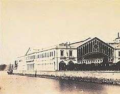
.jpg) A view of the Santa Apolónia railway station, along Rua Terceira Lopes | |
| Official name: Estação do Cais dos Soldados/Estação Ferroviária de Santa Apolónia | |
| Named for: Santa Apolonia | |
| Country | |
|---|---|
| Region | Lisbon |
| Subregion | Greater Lisbon |
| District | Lisbon |
| Municipality | Lisbon |
| Location | São Vicente |
| - coordinates | PT 38°42′49″N 9°7′23.4″W / 38.71361°N 9.123167°WCoordinates: PT 38°42′49″N 9°7′23.4″W / 38.71361°N 9.123167°W |
| Architects | Oppermann, Angel Arribas Ugarte, João Evangelista Abreu, Lecrenier |
| Materials | Masonry, Limestone, Glass, Wrought Iron, Wood |
| Owner | Portuguese Republic |
| For public | Public |
| Easiest access | Largo dos Caminhos de Ferro; Avenida Infante Dom Henrique; Rua dos Caminhos de Ferro |
| Management | Instituto Gestão do Patrimonio Arquitectónico e Arqueológico |
| Operator | Comboios de Portugal |
| Status | Unclassified |
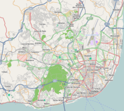 Location of the station within the municipality of Lisbon | |
| Wikimedia Commons: Santa Apolónia train station | |
The Santa Apolónia Station is oldest railway terminus in Portugal. Situated in the civil parish, in the central part of the municipality of Lisbon, on the northern margin of the Tagus River in the historical district of Alfama.
History
In December 1844, under the initiative of José Bernardo da Costa Cabral, the Companhia das Obras Públicas was founded, with the purpose of constructing a rail line between Lisbon and Spain, in addition to intermodal station between rail and maritime services. The station was known as the Cais da América or Cais da Europa, and allowed rail passengers from Europe to offload to ships for America.[1]
The initial project was for the construction at the Cais dos Soldados (Soldiers Wharf). Meanwhile, in December 1852, the engineer Thomaz Rumball proposed two alternatives, alongside the Museu Militar de Lisboa (Military Museum of Lisbon), or in the proximity of the Largo do Intendente. Another engineer, Harcourt White, also rejected the option of Cais dos Soldades on January 1853, affirming that there did not exist, in that local, sufficient space to construct a station. He suggested that the station be implanted along the river, after the Church of Anjos in Xabregas, where at the time there was free space. An executive committee was nominated to plan the construction of the Lisbon station, proposing the construction of a building along Rocha do Conde de Óbidos, with the capacity to receive passengers and commerce, with one of the lines continuing to area around the customs house in Terreiro do Paço.[2] The construction project to Spain, therefore, began this year, under orders of Fontes Pereira de Melo,[1]
The actual project to construct the station at Cais dos Soldados was approved by the government on 8 March 1854.[3] The plan presented a station that included distinctive elements for commercial and passenger traffic, repair workshops, warehouses and services. For the passenger terminal, the government acquired the old Convent of Santa Apolónia, but the former army arsenal in the location was demolished to make way for the final design. From the beginning, the rail line and the commercial wharf required that land be reclaimed along the Tagus River.[4]
At the inauguration of the first link of the Caminho de Ferro do Leste (Eastern line), between Carregado and Lisboa, on 28 September 1856, the construction of the station had not already begun.[3] In the meantime, the terminal was installed in the provisionary building along the Palácio de Coimbra (Palace of Coimbra).[5]
The project was designed by Angel Arribas Ugarte, and directed by director João Evangelista de Abreu, and his chief engineer Lecrenier, and constructed by the company Oppermann.[6][7][3] The station was inaugurated on 1 May 1865, with the first, with the first line to the station beginning operation in 1873, to connect Santa Apolónia to Santos.[6][8]
Between 1891 and 1957 most passenger services at Santa Apolónia moved to Rossio Train Station, then referred to as the Central Station. Santa Apolonia became one of several land transport hubs, that included Gare do Oriente, situated 6.5 kilometres (4.0 mi) southwest, Cais do Sodré, Rossio and Entrecampos.
From the 20th century, the national rail service Comboios de Portugal has operated different suburban, national and international routes (including links to Paris and Madrid, including the high-speed Alfa Pendular service. Santa Apolónia rail station is connected to the Lisbon Metro station of the same name, which opened in 2007. In January 2011, there were six means of transit, between 250–355 metres (820–1,165 ft) length; the platforms were between 172–348 metres (564–1,142 ft), and a height of 60–70 centimetres (24–28 in).[9]
Architecture
Santo Apolónia | |||||||||||
|---|---|---|---|---|---|---|---|---|---|---|---|
| Intermodal station | |||||||||||
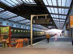
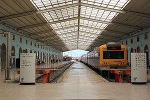 Intercidades (intercity) transport on the platform | |||||||||||
| Location |
Santo Apolónia Avenida Infante Dom Henrique 73 Lisboa 1100 São Vicente Portugal | ||||||||||
| Operated by | Comboios de Portugal | ||||||||||
| Line(s) |
Sintra line Norte line Azambuja line | ||||||||||
| Platforms | 8 | ||||||||||
| Train operators | Comboios de Portugal, Lisbon Metro | ||||||||||
| Connections | Lisbon Metro, Bus, Taxi | ||||||||||
| Construction | |||||||||||
| Disabled access | Station without architectural barriers, Ramp/lift for train access, Disabled toilets | ||||||||||
| Other information | |||||||||||
| Website | https://www.cp.pt/passageiros/en/train-times/Stations/Lisboa-Oriente | ||||||||||
| Services | |||||||||||
| |||||||||||
The station is situated along the northern margin of the Tagus River, in the Alfama district of Lisbon, integrated into the urban zone, along the Rua Caminhos de Ferro. Fronted by Rua Texeira Lopes, the three-register "U"-shaped building includes a short facade and long parallel wings extending around the rail platforms.
The principal symmetrical facade consists of a three-register Neoclassical, divided into five unequal veins. The first floor is dominated by five large rounded doorways, in addition to a lateral doorways on opposite ends of the facade, with rounded windows interspersed between the porticos.[7] On the second floor are rounded windows, with the central and lateral windows much larger and with lintels. On the final floor includes a triangular pediment dominated by a clock.[7] Similarly, the central and lateral vains include rounded windows, interlaced by square windows.[7]
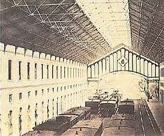
The main part of the building is dominated by a great nave, approximately 117 metres (384 ft) long, 24.6 metres (81 ft) wide and 13 metres (43 ft) tall, consisting of a lattice of wrought iron and glass, typical of the 19th century.
References
Notes
- 1 2 João Martins, Miguel Sousa & Madalena Brion (1996), p.11
- ↑ João Martins, Miguel Sousa & Madalena Brion (1996), p.26
- 1 2 3 Machado, João (2005), SIPA, ed., Estação do Cais dos Soldados/Estação Ferroviária de Santa Apolónia (IPA.00023182/PT031106291099) (in Portuguese), Lisbon, Portugal: SIPA –Sistema de Informação para o Património Arquitectónico, retrieved 14 February 2016
- ↑ João Martins, Miguel Sousa & Madalena Brion (1996), p.27
- ↑ João Martins, Miguel Sousa & Madalena Brion (1996), p.15
- 1 2 José Santos (1998), p. 328
- 1 2 3 4 Nunes, Bruna; Mascoli, Diana; Henriques, Rodrigo (1 February 2009), Estação de Santa Apolónia (in Portuguese), Blog Arquitectura do Ferro, retrieved 12 February 2010
- ↑ João Martins, Miguel Sousa & Madalena Brion (1996), p.29
- ↑ Rede Ferroviária Nacional (6 January 2011), p.73
Sources
- Almeida, D. Fernando de (1975), Monumentos e Edifícios Notáveis do Distrito de Lisboa, Lisboa - Tomo II (in Portuguese), Lisbon, Portugal
- Arquitectura de Engenheiros - séculos XIX e XX (in Portuguese) (Maio/Junho), Lisbon, Portugal: Fundação Calouste Gulbenkian, 1980
- Santos, José (1989), O Palácio de Cristal e Arquitectura de Ferro no Porto em Meados do Século XIX (in Portuguese), Porto, Portugal: Fundação Engenheiro António de Almeida, p. 387
- Martins, João; Sousa, Miguel de; Brion, Madalena (1996), O Caminho de Ferro Revisitado: O Caminho de Ferro em Portugal de 1856 a 1996 (in Portuguese), Caminhos de Ferro Portugueses