Santa Luzia (São Roque do Pico)
| Santa Luzia | |
| Civil Parish | |
 Coastal landscape around Arcos, in the parish of Santa Luzia, Pico Island | |
| Official name: Freguesia de Santa Luzia | |
| Name origin: Portuguese for Saint Lucia | |
| Country | |
|---|---|
| Autonomous Region | |
| Island | Pico |
| Municipality | São Roque do Pico |
| Localities | Arcos, Canto do Mistério, Fetais, Lajido, Lajido do Meio, Meio Mundo, Miraguaia, Ponta da Baixa, Ponta Negra, Rua de Cima, Santa Luzia |
| Center | Santa Luzia |
| - elevation | 127 m (417 ft) |
| - coordinates | 38°32′46″N 28°24′0″W / 38.54611°N 28.40000°WCoordinates: 38°32′46″N 28°24′0″W / 38.54611°N 28.40000°W |
| Highest point | Mount Pico |
| - elevation | 2,351 m (7,713 ft) |
| - coordinates | 38°28′6″N 28°23′56″W / 38.46833°N 28.39889°W |
| Lowest point | Sea level |
| - location | Atlantic Ocean |
| - elevation | 0 m (0 ft) |
| Area | 30.13 km2 (12 sq mi) |
| - urban | 1.12 km2 (0 sq mi) |
| Population | 422 (2011) |
| Density | 14/km2 (36/sq mi) |
| LAU | Junta Freguesia |
| - location | Edifício Polivalente |
| - coordinates | 38°32′33″N 28°24′34″W / 38.54250°N 28.40944°W |
| President Junta | Fernando Manuel Andrade Silva (PPD/PSD) |
| President Assembleia | Luís Manuel Menezes Fraga (PPD/PSD) |
| Timezone | Azores (UTC-1) |
| - summer (DST) | Azores (UTC0) |
| Postal Zone | 9940-125 |
| Area Code & Prefix | (+351) 292 XXX-XXXX |
| Patron Saint | Santa Luzia |
| Wikimedia Commons: Santa Luzia (São Roque do Pico) | |
Santa Luzia (Portuguese for Saint Lucia) is a civil parish in the municipality of São Roque do Pico in the Azores. The population in 2011 was 422,[1] in an area of 30.13 km².[2] It is the northernmost parish on the island.
Geography
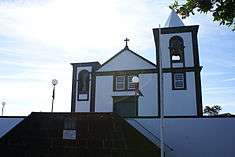
The front facade of the Church of Santa Luzia, in the centre of the community
Santa Luzia is located on the northern coast of the island and is connected by road encircling the island to its neighbors: Bandeiras in the west, and Santo António in the east. The area is relatively hilly and gradually slopes into the interior, reaching its peak (literally) in the Ponta do Pico.
References
This article is issued from Wikipedia - version of the 7/17/2016. The text is available under the Creative Commons Attribution/Share Alike but additional terms may apply for the media files.