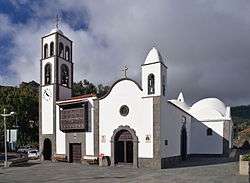
Santiago del Teide
| Santiago del Teide | |||
|---|---|---|---|
| Municipality | |||
 | |||
| |||
 Location in Tenerife | |||
| Coordinates: 28°17′50″N 16°48′50″W / 28.29722°N 16.81389°WCoordinates: 28°17′50″N 16°48′50″W / 28.29722°N 16.81389°W | |||
| Country |
| ||
| Autonomous Community |
| ||
| Province | Tenerife | ||
| Island | Tenerife | ||
| Government | |||
| • Mayor | Juan D. Gorrín Ramos (PP) | ||
| Area[1] | |||
| • Total | 52.21 km2 (20.16 sq mi) | ||
| Elevation(AMSL) | 925 m (3,035 ft) | ||
| Population (2013)[2] | |||
| • Total | 12,634 | ||
| • Density | 240/km2 (630/sq mi) | ||
| Time zone | CET (UTC+0) | ||
| • Summer (DST) | CEST (GMT +1) (UTC+1) | ||
| Postal code | 38690 / 38683 | ||
| Area code(s) | +34 (Spain) + 922 (Tenerife) | ||
| Climate | Csb | ||
| Website |
www | ||
Santiago del Teide is a town and a municipality in the western part of the island Tenerife, Canary Islands, and part of the province of Santa Cruz de Tenerife. The area of the municipality is 52.21 km²,[1] the population is 12,634 (2013).[2] Beach resort towns in the municipality are Los Gigantes, Puerto de Santiago and Playa de la Arena. The steep cliffs Acantilados de Los Gigantes are situated on the coast of the municipality.
References
- 1 2 Instituto Canario de Estadística, area
- 1 2 Instituto Canario de Estadística, population
 |
Buenavista del Norte | Los Silos and El Tanque | Garachico and Icod de los Vinos | |
| Atlantic Ocean | |
|||
| ||||
| | ||||
| Guía de Isora |
| Wikimedia Commons has media related to Santiago del Teide. |
This article is issued from Wikipedia - version of the 6/23/2016. The text is available under the Creative Commons Attribution/Share Alike but additional terms may apply for the media files.