Santo Antônio River (Doce River)
| Santo Antônio River | |
|---|---|
|
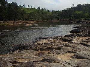
Santo Antônio River in Santo Antônio do Rio Abaixo. | |
| Basin | |
| Main source | Conceição do Mato Dentro |
| Physical characteristics | |
| Length | 287 km (178 mi) |
The Santo Antônio River of Brazil rises in the Espinhaço mountains, in the district of Santo Antônio do Cruzeiro, city of Conceição do Mato Dentro, in the Brazilian state of Minas Gerais. Running to the east, after a journey of 287 km, will pour its waters into the Rio Doce.
The bandeirantes used the river as a transportation route during the Brazil Gold Rush. Today it is used for fishing and gold panning, as well as leisure and tourism.
The Santo Antônio River is notable for its rocky course with a number of waterfalls, including Bahia Falls and Tabuleiro Falls (rated in the 2005 edition of Guia 4 Rodas as the prettiest in Brazil).
Cities of the basin of Santo Antônio River
- Conceição do Mato Dentro
- Morro do Pilar
- Santo Antônio do Rio Abaixo
- São Sebastião do Rio Preto
- Ferros
- Braúnas
- Joanésia
- Açucena
- Mesquita
- Belo Oriente
- Naque
| ||
This article is issued from Wikipedia - version of the 7/24/2016. The text is available under the Creative Commons Attribution/Share Alike but additional terms may apply for the media files.