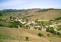
Santo Antônio do Aventureiro
| Santo Antônio do Aventureiro | |
|---|---|
| Municipality | |
 | |
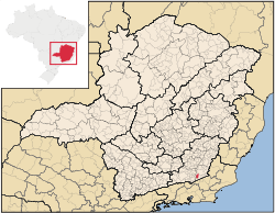 Location in Minas Gerais state | |
 Santo Antônio do Aventureiro Location in Brazil | |
| Coordinates: 21°45′28″S 42°48′57″W / 21.75778°S 42.81583°WCoordinates: 21°45′28″S 42°48′57″W / 21.75778°S 42.81583°W | |
| Country |
|
| Region | Southeast Region |
| State | Minas Gerais |
| Area | |
| • Total | 202.03 km2 (78.00 sq mi) |
| Population (2015) | |
| • Total | 3,659 |
| • Density | 18/km2 (47/sq mi) |
| Time zone | BRT/BRST (UTC-3/-2) |
| Website |
www |
Santo Antônio do Aventureiro is a municipality in the state of Minas Gerais, Brazil. The population is 3,659 (2015 est.) in an area of 202.03 km².[1] The elevation is 385 m. It became an independent municipality in 1962.
References
External links
- http://www.citybrazil.com.br/sp/stoantonioaventureiro/ (in Portuguese)
This article is issued from Wikipedia - version of the 9/16/2016. The text is available under the Creative Commons Attribution/Share Alike but additional terms may apply for the media files.