Sapir, Israel
| Sapir | |
|---|---|
 | |
 Sapir | |
| Coordinates: 30°36′50.04″N 35°11′3.48″E / 30.6139000°N 35.1843000°ECoordinates: 30°36′50.04″N 35°11′3.48″E / 30.6139000°N 35.1843000°E | |
| District | Southern |
| Council | Central Arava |
| Founded | 1979 |
| Population (2015)[1] | 374 |
| Website | sarigim.org.il |
college
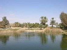
KKL park: life in the desert
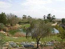
KKL park
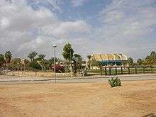
Sapir (Hebrew: סַפִּיר) is a communal settlement in southern Israel. Located near Route 90, it falls under the jurisdiction of Central Arava Regional Council. In 2015 it had a population of 374.
History
The village was established in 1979 and is named after Pinchas Sapir. It was planned by the architect Gershon Tzippor and was founded primarily to provide housing for municipal workers of the regional council. As time passed, its nature changed. As of 2006 it houses mostly people of various professions, as opposed to other settlements of the Arabah, which mostly do agriculture.
Near the community there is a nature park and an airstrip.
References
- ↑ "List of localities, in Alphabetical order" (PDF). Israel Central Bureau of Statistics. Retrieved 16 October 2016.
This article is issued from Wikipedia - version of the 11/22/2016. The text is available under the Creative Commons Attribution/Share Alike but additional terms may apply for the media files.