Saskatchewan Highway 641
641  | ||||
|---|---|---|---|---|
 | ||||
| Route information | ||||
|
Maintained by Ministry of Highways and Infrastructure & Transport Canada | ||||
| Length: | 153.30 km[1] (95.26 mi) | |||
| Major junctions | ||||
| South end: |
| |||
|
| ||||
| North end: |
| |||
| Location | ||||
| Rural municipalities: | Redburn, Pense, Lumsden No. 189, Longlaketon, Mount Hope | |||
| Highway system | ||||
|
Provincial highways in Saskatchewan
| ||||
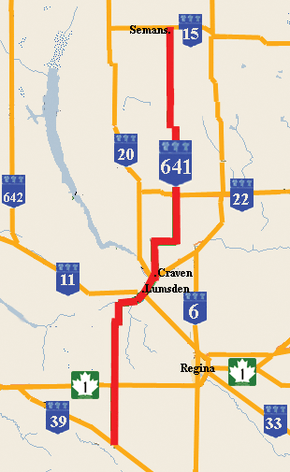
Saskatchewan Highway 641 is a highway in the province of Saskatchewan, Canada, beginning at Highway 39 near Rouleau, and traveling north ending at Highway 15 at Semans. The highway intersects the Trans Canada Highway, Saskatchewan Highway 1 south of Pense and east of Belle Plaine, Highway 20 at Lumsden, and Highway 22 at Earl Grey. Local Improvement Districts were the precursors of rural municipalities which initially established and maintained roads in their area. Early settlers helped to construct and maintain the route and would get paid road improvement wages from the local rural municipality. The 8 kilometres (5.0 mi) concurrency between Highway 20 and Highway 641 was constructed in 1927 following the removal of the Canadian National Railway line between Lumsden and Craven. The remainder of the road followed Dominion land survey township and range lines.
Route description
Highway 641 begins near Rouleau and extends north 22.1 kilometres (13.7 mi) to the Trans Canada Highway Highway 1 intersection. The rural municipality (RM) of Reburn number 130 office is located in Rouleau and administers to a population of 245.[2][3] This area is part of the Regina Plain landscape area of the Moist Mixed Grassland ecoregion featuring mainly cereal crops in the dark brown soils.[4] The RM of Pense is located between the city of Moose Jaw and the provincial capital city of Regina. At km 24.6 Highway 641 enters the village Pense.[5] At km 25.4, it intersects Saskatchewan Highway 730. Highway 730 connects to Regina, Saskatchewan east of this intersection. Lumsden is located at the km 55.9 intersection with Highway 11 in the Qu'Appelle Valley created by the Qu'Appelle River.[6]
The town of Lumsden features the Lumsden Museum which is home to several restored heritage buildings.[7][8] The Lumsden Trans Canada Trail Committee helped establish 20 kilometres (12 mi) of the Trans Canada trail. The trail has been groomed for walking, hiking, cycling, skiing, horseback riding, canoeing and snowmobiling.[9] Craven, the home of the Craven Country Jamboree, is located at the Highway 99 and Highway 20 junctions. Highway 641 continues north for 11.5 kilometres (7.1 mi) and then turns east 6.4 kilometres (4.0 mi) before again continuing northerly. This final stretch of the highway is part of the Strasbourg Plain landscape area of the Moist Mixed Grassland ecoregion featuring small trembling aspen (Populus tremuloides ) bluffs around the occasional slough.[4] Earl Grey is located at the intersection with Highway 22. There are no localities located at the intersection with the secondary Highway 731. Last Mountain House Provincial Park protects the heritage site of the Hudson's Bay Company post Last Mountain House established in 1869.[10] The terminus of Highway 641 is at the Saskatchewan Highway 15 intersection at Semans.[1]
History
Between 1897 and 1909, municipal administration affairs were handled by Local Improvement District (LID) Number 165. The LID changed its boundaries on December 13, 1909, and on January 1, 1913, the LID was renamed Pense No. 160. During the 1940s work was undertaken on paving roadways, a man could earn 35 cents an hour or $5.08 today a man and two horses could be employed at a rate of 65 cents an hour $9.43 today, a horse drawn drag would earn 37.5 cents an hour $5.44 today, and if a farmer owned a tractor, a tractor drawn drag could earn as much as 50 cents per hour $7.25 today.[11][6][12][13][14][15]
The Saskatchewan Highway Act was established in 1922, in compliance with the 1919 Canadian highway act. At the initial stages of the Saskatchewan Highway Act, 10 miles (16 km) of provincial highways were gravel and the rest were earth roads. The road allowances were laid out as a part of the Dominion Land survey system for homesteading.[16][17] Travel along the Provincial Highway 641 before the 1940s would have been traveling on the square following the township road allowances, barbed wire fencing and the Canadian Northern rail line. As the surveyed township roads were the easiest to travel, the first highway was designed on 90-degree, right-angle corners as the distance traversed the prairie along range roads and township roads.[18][19]
There is a historical monument erected along the highway which states that the early railway was established along the east side of the Last Mountain Lake (Long Lake) in 1907, and constructed on the west side in 1911. The monument documents as well the "Lady of the Lake" sternwheeler which was used on Long Lake. Local historians clarify that the rail came to the east of the Lake in 1911, and to the west in 1912. The "Lady of the Lake" began as a sternwheeler, but was modified to a screw propeller. Also on the Lake the "S.S. Qu'Appelle", a luxurious steamer, towed a barge across the lake.[20]
Lumsden was initially served by the Canadian National Railway CNR, however the Canadian Pacific Railway CPR was built through Craven in 1910. The new line brought freight to Lumsden infrequently and the elevator was torn down in 1927, and the CNR track removed the next year. The highway went through where the CNR bridge had been built.[20] Highway 20 is marked on an early 1926 and 1955 maps, but highway 641 is unmarked - showing up as surveyed township and range roads only.[21][22]
Intersections
| Rural municipality | Location | km[23] | mi | Destinations | Notes |
|---|---|---|---|---|---|
| Redburn No. 130 | 0 | 0.0 | Southern terminus | ||
| Pense No. 160 | 22.1 | 35.6 | |||
| 24.6 | 39.6 | 730 | |||
| Lumsden No. 189 | Lumsden | 55.9 | 90.0 | South end of concurrency with | |
| Longlaketon No. 219 | Craven | 65.6 | 105.6 | North end of concurrency with | |
| Earl Grey | 98.3 | 158.2 | |||
| 112.8 | 181.5 | 731 | |||
| Mount Hope No. 279 | Semans | 153.3 | 246.7 | Northern terminus of Hwy 641 | |
| 1.000 mi = 1.609 km; 1.000 km = 0.621 mi | |||||
References
- 1 2 Microsoft Streets and Tips (Map) (2004 ed.). Microsoft Corp. § Route Planner.
- ↑ Community Profiles from the 2006 Census, Statistics Canada. Statistics Canada. Government of Canada. 2008-12-22. Retrieved 2009-01-11.
- ↑ "Municipal Directory System". Government of Saskatchewan. Retrieved 2009-01-11.
- 1 2 Kai-iu Fung; Bill Barry; Wilson, Michael, eds. (1999). Ecoregions. Atlas of Saskatchewan Celebrating the Millennium (Millennium ed.). Saskatchewan: University of Saskatchewan. pp. 160–163. ISBN 0-88880-387-7.
- ↑ "Village of Pense". 2007. Retrieved 2009-01-11.
- 1 2 "Postcard Views of Lumsden". 2007. Retrieved 2009-01-11.
- ↑ "Welcome to the Town of Lumsden". Retrieved 2009-01-11.
- ↑ "Photographs of the Province of Saskatchewan, Canada: Lumsden Museum:". 30 Jun 2005. Retrieved 2009-01-11.
- ↑ "The Trans Canada Trail". Retrieved 2009-01-11.
- ↑ "Last Mountain House Provincial Park Tourism Parks Culture and Sport". Government of Saskatchewan. 2009. Retrieved 2009-02-11.
- ↑ Federal Reserve Bank of Minneapolis Community Development Project. "Consumer Price Index (estimate) 1800–". Federal Reserve Bank of Minneapolis. Retrieved October 21, 2016.
- ↑ "A History of the Canadian Dollar". Le Site De Justiceplus - The Justiceplus Site. Archived from the original on 2008-12-21. Retrieved 2008-12-28. Rationale to use US currency conversion template. $10 Canadian was equivalent to US$10 gold eagle 1851-1867. 1879-1914 the US and Canadian dollar traded again at par.
- ↑ "The Canadian Dollar under the Gold Standard (1854-1914)" (pdf). Bank of Canada. Retrieved 2008-12-28. Rationale to use US currency conversion template. Bank of Canada notes that from 1854-1914 the US and Canadian dollar traded at par.
- ↑ "History". Rural Municipality of Pense 160. 2007. Archived from the original on September 21, 2009. Retrieved 2009-01-11.
- ↑ "Rural Municipality of Pense 160". 2007. Retrieved 2009-01-11.
- ↑ Coupland, R.T. (1969). "Transportation in Saskatchewan". In J.H. Richards; K.I. Fung. Atlas of Saskatchewan. J.S. Rowe. Saskatoon, SK, CA: University of Saskatchewan. p. 174.
- ↑ "To find Lands in the Field Canadian National Railways - Western Canada - c1905.". Canadian Maps Online Digitization Project. Rootsweb Saskatchewan Gen Web. Retrieved 2008-01-08.
- ↑ Adamson, J (14 October 2003). "Canadian maps 1926 Highway Map". Department of Highways. Canadian Maps Online Digitization Project. Retrieved 2009-01-10.
- ↑ Adamson, J (14 October 2003). "Canadian maps 1925 Waghorn's Guide". Department of Highways. Canadian Maps Online Digitization Project. Retrieved 2009-01-10.
- 1 2 Harvest of Memories : Sturgis and District, The First Hundred Years : 1900-2000. (Digitised online by Our Roots Nos Racines). Sturgis, Saskatchewan: Sturgis and District History Book Committee,. 2000. pp. 2, 59, 83, 188. Retrieved 2009-02-15.
- ↑ Adamson, J (14 October 2003). "Canadian maps 1926 Highway Map". Department of Highways. Canadian Maps Online Digitization Project. Retrieved 2008-02-10.
- ↑ "The Atlas of Canada - Major Roads, 1955". Natural Resources Canada, Earth Sciences Sector, Geomatics Canada. Government of Canada. 2004-07-19. Retrieved 2009-02-15.
- ↑ Microsoft Streets and Tips (Map) (2004 ed.). Microsoft Corporation Redmond Washington.
External links