Trans-Canada Highway
| |
|---|---|
|
| |
| Route information | |
| Length: |
8,030 km[1] (4,990 mi) South route: 2,960 km (1,840 mi) |
| Existed: | 30 July 1962[2] – present |
| Major junctions | |
| From: | Victoria, British Columbia |
| To: | St. John's, Newfoundland and Labrador |
| Location | |
| Major cities: | Victoria, Vancouver, Calgary, Edmonton, Regina, Saskatoon, Winnipeg, Ottawa, Montreal, Quebec City, Charlottetown, Fredericton, Moncton, Sydney, St. John's |
| Highway system | |
|
| |
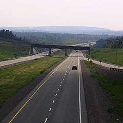
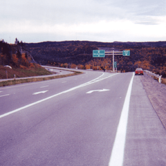
The Trans-Canada Highway (French: Route Transcanadienne) is a transcontinental federal-provincial highway system that travels through all ten provinces of Canada between its Pacific Ocean and Atlantic Ocean coasts to the west and east respectively. It is, along with the Trans-Siberian Highway and Australia's Highway 1, one of the world's longest national highways, with the main route spanning 8,030 km (4,990 mi). The system was approved by the Trans-Canada Highway Act of 1949,[3] with construction commencing in 1950.[4] The highway officially opened in 1962, and was completed in 1971. Upon its original completion, the Trans-Canada Highway was the most lengthy uninterrupted highway in the world.[5] The highway system is recognizable by its distinctive white-on-green maple leaf route markers.
Throughout much of Canada, there are at least two routes designated as part of the Trans-Canada Highway (TCH). For example, in the western provinces, both the main Trans-Canada route and the Yellowhead Highway are part of the Trans-Canada system. Although the TCH does not enter any of Canada's three northern territories, the Trans-Canada Highway forms part of Canada's overall National Highway System, providing connections to the Northwest Territories, Yukon and the Canada–US border.[6]
In 2012, a series of free public electric vehicle charging stations were installed along the main route of the highway by a private company, Sun Country Highway, permitting electric vehicle travel across the entire length, as demonstrated by the company's president, Kent Rathwell, in a publicity trip in a Tesla Roadster. As of 2012 this made it the longest electric vehicle ready highway in the world.[7][8]
Jurisdiction
Canada's national highway system is not primarily under federal jurisdiction, as decisions about highway and freeway construction are entirely under the jurisdiction of the individual provinces. In 2000 and 2001, the government of Jean Chrétien considered funding an infrastructure project to have the full Trans-Canada system converted to freeway. Although freeway construction funding was made available to some provinces for portions of the system, the government ultimately decided not to pursue a comprehensive highway conversion. Opposition to funding the freeway upgrade was due to low traffic levels on parts of the Trans-Canada.
Plans for a freeway to bypass or eliminate traffic congestion and road hazards along the heavily travelled route from Victoria to Nanaimo on Vancouver Island were cancelled during the recession that followed the 1987 stock market crash. The cancellation was confirmed in 1995 by the federal government's "war on the deficit" and British Columbia's subsequent highway capital spending freeze. The latter was lifted from the Trans-Canada Highway development program on the BC mainland as renewed federal funding and new public-private partnerships became available in the early 2000s to support the 2010 Winter Olympics and the Pacific Gateway transportation initiative. However, the freeze was largely left in place for the Vancouver Island TCH which was becoming seen mostly as a commercial local service corridor isolated from the increasingly high-mobility highway networks on the Canadian mainland.
Route numbering on the Trans-Canada Highway is also handled by the provinces. The Western provinces have coordinated their highway numbers so that the main Trans-Canada route is designated Highway 1 and the Yellowhead route is designated Highway 16 throughout; however, from the Manitoba–Ontario border eastwards, the highway numbers change at each provincial boundary, or even change within a province as the TCH piggybacks along separate provincial highways (which often continue as non-TCH routes outside the designated sections) en route. In addition, Ontario and Quebec use standard provincial highway shields to number the highway within their boundaries, but post numberless Trans-Canada Highway shields alongside them to identify it. As the Trans-Canada route was composed of sections from pre-existing provincial highways, it is unlikely that the Trans-Canada Highway will ever have a uniform designation across the whole country.
Route details
Victoria–Winnipeg


The Trans-Canada Highway, uniformly designated as Highway 1 in the four western provinces, begins in Victoria, British Columbia at the intersection of Douglas Street and Dallas Road (where the "Mile 0" plaque stands) and passes northward along the east coast of Vancouver Island for 99 km (62 mi) to Nanaimo. Short freeway segments of the TCH can be found near Victoria and Nanaimo, but the rest of the highway on Vancouver Island operates mostly as a heavily signalized low-to-limited-mobility arterial road that uniquely (for the Trans-Canada Highway system) does not bypass any of its areas of urban sprawl, particularly Nanaimo and Duncan. It is also one of only two parts of the Trans-Canada system in which the highway is officially designated as north-south, the other being Autoroute 85/Route 185 from Autoroute 20 in Quebec to the New Brunswick border (the Trans-Canada is otherwise designated as east-west from Nanaimo to St. John's, although there are significant north-south sections north of Hope, Sault Ste. Marie, and Fredericton). The section of Highway 1 that crosses the Malahat northwest of Victoria has no stoplights yet, but is tightly pinched by rugged terrain that prevents comprehensive widening to four lanes and sometimes forces closure for hours at a time after a traffic accident. The Departure Bay ferry is the only marine link on the Trans-Canada system that has no freeway or other high mobility highway access, instead routing TCH traffic through downtown Nanaimo streets to reach the ferry to Vancouver.
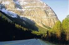
From Departure Bay, a 57 km (31 nmi) ferry route (see BC Ferries) connects the highway to Horseshoe Bay in West Vancouver. At this point, the Trans-Canada Highway becomes a high mobility freeway and passes through the Vancouver metropolitan area, crossing the Fraser River with the Port Mann Bridge. The section around the Bridge has started being electronically tolled as of 8 December 2012; signs indicate a free alternate route using Highway 17 instead of the TCH. From Horseshoe Bay, the TCH then heads 170 km (110 mi) east through the Fraser Valley to Hope. The TCH then turns north for 186 km (116 mi) through the Fraser Canyon toward Cache Creek as a mostly high mobility highway with only occasional mandatory stops, then east for 79 km (49 mi) through to Kamloops where it becomes a short freeway. Then it continues 496 km (308 mi) east through Salmon Arm, Revelstoke, Rogers Pass, Golden, and Kicking Horse Pass (the highest point on the highway, at 1,627 metres), to Banff, Alberta as a mostly high mobility highway.
From Banff, there is another 101 km (63 mi) east as a freeway to Calgary where it becomes known as 16th Avenue N, a road with heavy traffic and many traffic lights that can now be bypassed by Highway 201 which loops north of the city. After that it is another 293 km (182 mi) east to Medicine Hat on divided highway, then 403 km (250 mi) east to Moose Jaw, Saskatchewan and 79 km (49 mi) east to Regina which is bypassed by a short freeway segment. After Regina it is another 372 km (231 mi) east to Brandon, Manitoba, 119 km (74 mi) east to Portage la Prairie, and finally 84 km (52 mi) east to Winnipeg. The southern portion of Winnipeg's Perimeter Highway (Highway 100) is part of the Trans-Canada system and bypasses the city and has a mix of traffic lights and interchanges, while Highway 1 continues through the urban core of Winnipeg.
Throughout the prairie provinces, the speed limit varies from 90 km/h (56 mph) to 110 km/h (68 mph). As is the case with all highways passing through national parks in Canada, the speed limit is 90 km/h (55 mph) through Banff National Park. East of Banff, most of Highway 1 through Alberta, Saskatchewan, and Manitoba[9] is 110 km/h (68 mph), but is 100 km/h east of Winnipeg. Speed limits on the British Columbia mainland segment of the Trans-Canada range from 80 km/h (50 mph) to 110 km/h (68 mph). A combination of difficult terrain and growing urbanization limits posted speeds on the Vancouver Island section to 50 km/h (31 mph) in urban areas, 80 km/h (50 mph) across the Malahat and through suburban areas, and a maximum of 90 km/h (55 mph) in rural areas.
There is also a route, the Crowsnest Highway, in British Columbia and Alberta (Highway 3), which connects with the Highway 1 at both termini (Hope and Medicine Hat) but is not officially part of the Trans-Canada system.
Prior to the 2008 economic downturn, the highway underwent some upgrades through the Rocky Mountains from Banff National Park to Golden, British Columbia. A major piece of this project was completed in 2007 with the new Park Bridge and Ten Mile Hill sections. There are long-term plans to twin the highway from Lake Louise to Kamloops, although a start date has not been set because of a lack of funding.
In Alberta, construction from the Banff - Windermere Highway to Lake Louise, in which the highway was twinned to four lanes, was completed by winter 2010. Parks Canada completed twinning the final 8.5 km (5.3 mi) of Highway 1 between Lake Louise and the British Columbia border, with the new alignment opened to traffic on 12 June 2014.[10]
For more information, see also:
- Trans-Canada (Main) Route
- British Columbia Highway 1 (Trans-Canada Highway/Island Highway/Upper Levels Highway)
- Alberta Highway 1
- Saskatchewan Highway 1
- Manitoba Highway 1
- Manitoba Highway 100 (Winnipeg Perimeter Highway)
- Yellowhead Route
- British Columbia Highway 16 (Yellowhead Highway)
- British Columbia Highway 5 (Yellowhead Highway South/Coquihalla Highway)
- Alberta Highway 16 (Yellowhead Highway)
- Saskatchewan Highway 16 (Yellowhead Highway)
- Manitoba Highway 16 (Yellowhead Highway)
Winnipeg–Ottawa


The highway continues east from Winnipeg for another 205 km (127 mi) to Kenora. At the Ontario border, the number designation of the highway changes from 1 to 17.
At Kenora, the Trans-Canada designation includes both the main route through the city's urban core and the 33.6 km (20.9 mi) Highway 17A bypass route. The existing branch from Kenora continues east for 136 km (85 mi) to Dryden. A second branch extends 157 km (98 mi) southward along Highway 71 from Kenora to Chapple, then 320 km (200 mi) eastward along Highway 11 to Shabaqua Corners, where it reunites with Highway 17.
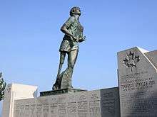
Highway 11/Highway17 proceeds southeast for 65 km (40 mi) to Thunder Bay, then northeast for 115 km (71 mi) to Nipigon. An 83 km (52 mi) section of the Trans-Canada Highway between Thunder Bay and Nipigon is commemorated as the Terry Fox Courage Highway. Fox was forced to abandon his cross-country Marathon of Hope run here; a bronze statue of him was erected in his honour. The section near Nipigon is narrowest in the Canadian road network. The highway is the only road that connects eastern and western Canada, often creating a traffic bottleneck. On 10 January 2016, the Nipigon River Bridge suffered a mechanical failure, closing the Trans-Canada Highway briefly and forcing travelers to go around Lake Superior;[11]
The Trans-Canada Highway designation splits east of Nipigon; the northern branch follows Highway 11 and the southern branch follows Highway 17. Highway 11 travels a 985 km (612 mi) arc through Northern Ontario, passing through Hearst, Kapuskasing, Cochrane, and Temiskaming Shores before continuing along Highway 17 east from North Bay. A spur branches eastward from Highway 11 near Kirkland Lake, following Highway 66 for 58 km (36 mi) into Quebec, and then Route 117 and Autoroute 15 for 674 km (419 mi) into Montreal.
Highway 17 proceeds east from Nipigon for 581 km (361 mi) along the northern and eastern coast of Lake Superior. Between Wawa and Sault Ste. Marie, the highway crosses the Montreal River Hill, which sometimes becomes a bottleneck on the system in the winter when inclement weather can make the hill's steep grade virtually impassable.[12] At Sault Ste. Marie, the highway turns eastward for 291 km (181 mi) east to Sudbury. The Trans-Canada Highway splits again at the junction of Highways 17 and 69 on Sudbury's Southwest and Southeast Bypasses.
- The southern route follows Highways 69 and 400 south for 254 km (158 mi) and then Highway 12 for 27 km (17 mi) to Orillia, a further 58 km (36 mi) along the shore of Lake Simcoe, before following Highway 7 east for 70 km (43 mi) to Peterborough.
- The northern route continues east for 151 km (94 mi) to North Bay, and then 216 km (134 mi) to Pembroke.
The two branches converge at Ottawa, 244 km (152 mi) east of Peterborough and 123 km (76 mi) east of Pembroke. In Southern Ontario, the speed limit is generally 80 km/h (50 mph) on the Trans-Canada, while in Northern Ontario it is 90 km/h (56 mph). Sections routed along provincial freeways feature a higher limit of 100 km/h (62 mph).
It is notable that the Trans-Canada barely passes through Canada's most heavily populated region, the Golden Horseshoe area of Southern Ontario, which includes the city of Toronto. However, a small section of the highway does briefly cross into the northeastern edge of Durham Region at both Sunderland and Beaverton, where this region itself is part of the Greater Toronto Area.
- Highway 7
- Highway 11
- Highway 12
- Highway 17
- Highway 66
- Highway 69
- Highway 71
- Highway 115
- Highway 400
- Highway 417
Ottawa to Quebec/New Brunswick border
From Ottawa, the Trans-Canada Highway proceeds 206 km (128 mi) east to Montreal, as Highway 417 in Ontario (and the Queensway in Ottawa) and Autoroute 40 in Quebec.
The Trans-Canada assumes the name "Autoroute Métropolitaine" (also known as "The Met" or "Metropolitan Boulevard") as it traverses Montreal as an elevated highway. This is the busiest section of the highway. At the Laurentian interchange, in Montreal, the Abitibi route (Highway 66/Route 117/A-15) rejoins the main TCH line. The TCH then follows Autoroute 25 southbound, crossing the St. Lawrence River through the Louis Hippolyte Lafontaine Bridge-Tunnel, and proceeds northeast on Autoroute 20 for 257 km (160 mi) to Lévis (across from Quebec City).
East of Lévis, the Trans-Canada Highway continues on Autoroute 20 following the south bank of the Saint Lawrence River to a junction just south of Rivière-du-Loup, 173 km (107 mi) northeast of Lévis. At that junction, the highway turns southeast and changes designation to Autoroute 85 for 13 km (8.1 mi), and then downgrades to Route 185 until Degelis where Autoroute 85 resumes near the New Brunswick border. The portion from Autoroute 20 to Edmundston, New Brunswick is 121 km (75 mi) long.
The Maritimes
New Brunswick
Following the designation of Route 2, from Edmundston, the highway follows the Saint John River Valley, running south for 170 km (110 mi) to Woodstock (paralleling the Canada–US border) and then east for another 102 km (63 mi) to pass through Fredericton. 40 km (25 mi) east of Fredericton, the Saint John River turns south whereby the highway crosses the river at Jemseg and continues heading east to Moncton another 135 km (84 mi) later. On 1 November 2007, New Brunswick completed a 20-year effort to convert its 516 km section of the Trans-Canada Highway into a four-lane freeway. The highway has a speed limit of 110 km/h.
From Moncton, the highway continues southeast for 54 km (34 mi) to a junction at Aulac close to the New Brunswick–Nova Scotia border (near Sackville) where the Trans-Canada Highway splits into the main route continuing to the nearby border with Nova Scotia as Route 2, and a 70 km (43 mi) route designated as Route 16 which runs east to the Confederation Bridge at Cape Jourimain.
Prince Edward Island
After crossing the Northumberland Strait on the 13 km (8.1 mi) Confederation Bridge to Borden-Carleton, the Trans-Canada Highway follows a 110 km (68 mi) route across southern Prince Edward Island, designated as Route 1. After passing through Charlottetown it ends at Wood Islands where a 26 km (16 mi) ferry route (operated by Northumberland Ferries Limited, or NFL) crosses the Northumberland Strait to Caribou, Nova Scotia (near Pictou). From the ferry terminal at Caribou, the highway continues south for another 19 km (12 mi) as Highway 106 to a junction with the direct Trans-Canada Highway route (Highway 104) at Westville (near New Glasgow).
Nova Scotia
From the New Brunswick border, the main Trans-Canada Highway route continues east into Nova Scotia at Amherst, where it follows the designation of provincial Highway 104. The highway then passes by Truro, where it links with provincial Highway 102 to Halifax, 117 km (73 mi) east of the New Brunswick border. Halifax, like Toronto and Quebec City, is a provincial capital not serviced by a Trans-Canada Highway. There is a 30 km (19 mi) stretch of highway with a toll of $4 per automobile (different rates for other vehicles).
From Truro, the highway continues east for 57 km (35 mi) to New Glasgow (where it links with provincial Highway 106—that portion of the Trans-Canada running to the ferry terminal at Caribou), and then northeast for another 112 km (70 mi) to the Canso Causeway which crosses the Strait of Canso to Cape Breton Island near Port Hawkesbury. From the Canso Causeway, the highway continues east for 144 km (89 mi) using the designation of Highway 105 on Cape Breton Island, until reaching the Marine Atlantic ferry terminal at North Sydney.
Port aux Basques–St. John's
From North Sydney, a 177 km (110 mi) ferry route, operated by the Crown corporation Marine Atlantic, continues the highway to Newfoundland, arriving at Channel-Port aux Basques, whereby the Trans-Canada Highway assumes the designation of Highway 1 and runs northeast for 219 km (136 mi) through Corner Brook, east for another 352 km (219 mi) through Gander and finally ends at St. John's, another 334 km (208 mi) southeast, for a total of 905 km crossing the island. The majority of the Trans-Canada Highway in Newfoundland is undivided, though sections in Corner Brook, Grand Falls-Windsor, Glovertown and a 75 km section from Whitbourne to St. John's is divided.
"Mile zero"


Although there does not appear to be any nationally sanctioned "starting point" for the entire Trans-Canada Highway system, St. John's has adopted this designation for the section of highway running in the city by using the term "Mile One" for its sports stadium and convention centre complex, Mile One Centre. Likewise, the Victoria terminus of the Trans-Canada Highway, located at the foot of Douglas Street and Dallas Road at Beacon Hill Park, is marked by a "mile zero" monument. The Trans-Canada Highway has been posted in kilometres since 1977, when all Canadian roads switched to metric.
Although Highway 4 was commissioned in 1953 and is not part of the Trans-Canada Highway system, there is also a sign marking the Pacific terminus of the Trans-Canada Highway at Tofino, British Columbia, where Highway 4 terminates in the west, but it was most likely erected before 1953. Tofino, recognizing its need for tourism, was a strong proponent of a Trans-Canada Highway since the 1920s, when the only roads in the area were gravel. The community was bypassed by the official Trans-Canada Highway in the 1950s, when government prioritized the connection of major communities in its budgets, choosing instead to connect Nanaimo with Victoria.
See also
References
- ↑ "Trans-Canada Highway: Bridging the Distance". CBC Digital Archives.
- ↑ "Trans-Canada Highway". Unpublished Guides. Library and Archives of Canada. Retrieved 29 July 2011.
- ↑ "Trans-Canada Highway Act". Department of Justice Canada. R.S.C. 1970, c. T-12.
- ↑ "The Trans-Canada Highway". Transport Canada.
- ↑ MacLeod, Donaldson (2014). "The Trans-Canada Highway: A Major Link in Canada's Transportation System" (PDF). Transportation Association of Canada. Retrieved 10 March 2016.
- ↑ "National Highway System" (PDF). Transport Canada. Retrieved 26 April 2014.
- ↑ Caulfield, Jane (11 December 2012). "Electrifying Trip Along the Trans-Canada Highway Pit Stops in Saskatchewan". Metro. Retrieved 12 April 2014.
- ↑ "World's Longest Greenest Highway Project - Item Details | Sun Country Highway". Sun Country Highway. Retrieved 2016-11-01.
- ↑ "Manitoba Trans-Canada Speed Limit Goes Up to 110 km/h Today". CBC Manitoba. 2015. Retrieved 2 June 2015.
- ↑ "Crews Complete Twinning of Trans-Canada Through Banff National Park". CTV Calgary. 13 June 2014. Retrieved 13 June 2014.
- ↑ "Nipigon River Bridge on Trans-Canada Highway partially reopens". CBC News. Retrieved 2016-11-28.
- ↑ "The Montreal River hill: Nine years for nothing?". Northern Ontario Business. May 16, 2006. Retrieved November 17, 2016.
External links
![]() Media related to Trans-Canada Highway at Wikimedia Commons
Media related to Trans-Canada Highway at Wikimedia Commons
- Trans-canada highway.com—Detailed province by province description
 Trans-Canada Highway travel guide from Wikivoyage
| British Columbia | ||
|---|---|---|
| Alberta | ||
| Saskatchewan | ||
| Manitoba | ||
| Ontario | ||
| Quebec | ||
| New Brunswick | ||
| Prince Edward Island | ||
| Nova Scotia | ||
| Newfoundland | ||
| ||