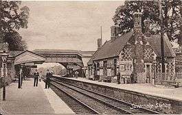
Savernake Low Level railway station
| Savernake Low Level | |
|---|---|
 | |
| Location | |
| Place | Burbage |
| Area | Wiltshire |
| Grid reference | SU236632 |
| Operations | |
| Original company | Berks and Hants Extension Railway |
| Pre-grouping | Great Western Railway |
| Post-grouping | Great Western Railway |
| Platforms | 3 |
| History | |
| 11 November 1862 | Opened as Savernake |
| 1 July 1924 | Renamed Savernake Low Level |
| 11 September 1961 | Renamed Savernake for Marlborough |
| 18 April 1966 | Closed |
| Disused railway stations in the United Kingdom | |
|
Closed railway stations in Britain A B C D–F G H–J K–L M–O P–R S T–V W–Z | |
|
| |
Savernake Low Level railway station was a station on the Berks and Hants Extension Railway, near the village of Burbage in Wiltshire, England. It was open from 1862 until 1966.
History
_%26_Andover(Red_Posts)_RJD_107.jpg)
The Berks and Hants Extension Railway, which ran from Hungerford to Devizes, opened on 11 November 1862, and the station named Savernake was opened with the line.[1][2] It was situated between Bedwyn and Pewsey stations,[3] about 0.6 miles (1 km) northeast of the village of Burbage where the line passed over the road to Durley.[4] The site is directly above the Bruce Tunnel which carries the Kennet and Avon Canal.
There was a goods station at Burbage Wharf, about three-quarters of a mile to the west, providing an interchange between the railway, the canal and the road to Marlborough. This was closed in 1947.[5]
On 15 April 1864, the Marlborough Railway opened its short branch line to Marlborough, which was operated by the Great Western and then taken over by it, and Savernake became a junction.[6]
When the Reading to Taunton line was created and the Stert to Westbury cut-off opened in 1900, the platforms at Savernake were lengthened, the footbridge roofed and brick waiting rooms provided on the down platform. Until 1916, Savernake then had six trains a day, plus up to six slip coaches from Paddington, the fastest covering the 70 mi (110 km) to Savernake in 75 minutes. In the 1950s Savernake had ten trains a day on the main line, seven to Marlborough and two other Midland and South Western Junction Railway trains.[7]
On 1 July 1924, the station was renamed Savernake Low Level; the nearby station on the former Midland and South Western Junction Railway line becoming Savernake High Level at the same time.[2]
The station was renamed Savernake for Marlborough on 11 September 1961 when the High Level station officially closed,[2] although through trains on the former M&SWJR had used Savernake Low Level for some time because of a landslip on the original line.
The station closed on 18 April 1966[2] but the first-built line remains in use, providing a route from Reading and Hungerford to Westbury and beyond.
Routes
| Preceding station | Historical railways | Following station | ||
|---|---|---|---|---|
| Bedwyn Line and station open |
Great Western Railway Berks and Hants Extension Railway |
Wootton Rivers Halt Line open, station closed | ||
| Disused railways | ||||
| Marlborough High Level Line and station closed |
Great Western Railway Marlborough branch |
Terminus | ||
| Marlborough Low Level Line and station closed |
Midland and South Western Junction Railway Swindon, Marlborough and Andover Railway |
Grafton and Burbage Line and station closed | ||
References
- ↑ MacDermot, E.T. (1927). History of the Great Western Railway, vol. I: 1833-1863. Paddington: Great Western Railway. p. 438.
- 1 2 3 4 Butt, R.V.J. (1995). The Directory of Railway Stations. Yeovil: Patrick Stephens Ltd. p. 206. ISBN 1-85260-508-1. R508.
- ↑ Conolly, W. Philip (January 1976). British Railways Pre-Grouping Atlas and Gazetteer (5th ed.). Shepperton: Ian Allan. p. 4, section A5. ISBN 0-7110-0320-3. EX/0176.
- ↑ Crowley, D.A. (ed.). "Victoria County History - Wiltshire - Vol 16 pp69-82 - Burbage". British History Online. University of London. Retrieved 10 March 2016.
- ↑ Oakley, Mike (2004). Wiltshire Railway Stations. Wimborne: The Dovecote Press. p. 116. ISBN 1904349331.
- ↑ MacDermot, E.T. (1931). History of the Great Western Railway, vol. II: 1863-1921. Paddington: Great Western Railway. p. 6.
- ↑ Railway Magazine March 1958 T B Sands: Savernake, a Railway Crossroads in Wiltshire pp. 195-201
External links
Coordinates: 51°22′03″N 1°39′44″W / 51.3675°N 1.6621°W