Sayago, Montevideo
| Sayago | |
|---|---|
| Barrio | |
|
The train station of Sayago | |
 Street map of Sayago | |
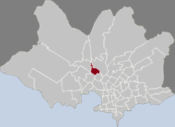 Location of Sayago in Montevideo | |
| Coordinates: 34°50′9″S 56°12′45″W / 34.83583°S 56.21250°WCoordinates: 34°50′9″S 56°12′45″W / 34.83583°S 56.21250°W | |
| Country |
|
| Department | Montevideo Department |
| City | Montevideo |

Sayago is a barrio (neighbourhood or district) of Montevideo, Uruguay.
Location
This barrio borders Conciliación to the northwest, Peñarol - Lavalleja to the northeast, Paso de las Duranas to the southeast and Belvedere to the southwest.
History
It was founded in 1873 and was declared a "Pueblo" (village) on 10 March 1913 by the Act of Ley N° 4.311.[1] On 1 July 1953, its status was elevated to "Villa" (town) by the Act of Ley N° 11.966.[2] Eventually, it has been integrated to Montevideo.
Places of worship
See also
References
- ↑ "Statistics of urban localities" (PDF). INE. 2012. Retrieved 9 September 2012.
- ↑ "Ley Nº 11.966". República Oriental del Uruguay, Poder Legislativo. 1953. Retrieved 9 September 2012.
- ↑ Maronite Church in Uruguay
External links
This article is issued from Wikipedia - version of the 8/16/2016. The text is available under the Creative Commons Attribution/Share Alike but additional terms may apply for the media files.