Scorton, North Yorkshire
| Scorton | |
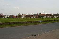 Scorton Village Green |
|
 Scorton |
|
| Population | 1,012 (Including Uckerby. 2011) |
|---|---|
| OS grid reference | NZ249002 |
| – London | 200 mi (320 km) S |
| District | Richmondshire |
| Shire county | North Yorkshire |
| Region | Yorkshire and the Humber |
| Country | England |
| Sovereign state | United Kingdom |
| Post town | RICHMOND |
| Postcode district | DL10 |
| Dialling code | 01748 |
| Police | North Yorkshire |
| Fire | North Yorkshire |
| Ambulance | Yorkshire |
| EU Parliament | Yorkshire and the Humber |
| UK Parliament | Richmond |
Coordinates: 54°23′49″N 1°36′42″W / 54.3969°N 1.6116°W
Scorton is a village and civil parish in the Richmondshire district of North Yorkshire, England. It is situated approximately 8 miles (13 km) north-west from the county town of Northallerton.
History
The village is mentioned in the Domesday Book as "Scortone" in the lands of Count Alan of Brittany, who was tenant-in-chief during the Norman invasion. Prior to the invasion, the manor was granted to Thorfin of Ravensworth, but subsequently granted in 1086 to Bodin, brother of Bardulf.[1] The manor was thereafter split into two parts, the larger granted to the Fitz Hugh family and the lesser to the Fitz Alan's. The descent of the larger part of the manor followed that of the manor of Kirkby Ravensworth until 1512 when it came into the Fiennes family, who were entitled as Baron Dacre. In 1600, the manor was left to Charles Tankard and Christopher Jeynes who sold it onto Leonard Wastell by 1616. Towards the latter part of the 18th century the manor passed to the Earl of Tyrconnel and followed that family's descent.[2][3]
The etymology of the name is derived from a combination of the Old Norse word skor, meaning a rift in the rock and the Old English suffix of tūn, meaning farm or setllemnt. Put together they mean ravine farm.[4][5]
Scorton was home to the now closed Scorton Grammar School from 1720–1991. Most of the buildings and grounds have been converted into houses. Scorton has a raised village green, one of only three in England. It is said that the green was built in the early 18th century by John Noble, the first headmaster of Scorton Grammar School. There was also a hospital, named St John of God, built in 1880 on the grounds of the former convent of St Clare. This is now the Residential Nursing Home, Abbey Care Village.[2][3]
Between 1939 and 1945, the village was home to RAF Scorton, which served as a satellite of RAF Catterick. The No. 56 Squadron RAF flew Spitfires from Scorton during the Second World War. The Aerodrome has now been extensively quarried away.
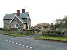
Scorton was once served by the Eryholme-Richmond branch line but the line was closed in 1969 – the station building is now a house and much of the line between Scorton railway station and Catterick Bridge has been destroyed by quarrying.[6]
Governance
The village lies within the Richmond UK Parliament constituency. It also lies within the Catterick Bridge electoral division of North Yorkshire County Council and the Brompton-on-Swale and Scorton ward of Richmondshire District Council.[7]
Geography
The village is located at the northern terminus of the B6271 from Northallerton where the B1263 from Richmond joins it. Scorton Beck, a tributary of the River Swale, flows south on the east side of the village. The nearest settlements are Bolton-on-Swale 0.5 miles (0.80 km) to the south, Catterick 1.4 miles (2.3 km) to the south west and Brompton-on-Swale 2 miles (3.2 km) to the west.[7]
Demography
| Population [8][9][10] | ||||||||||
|---|---|---|---|---|---|---|---|---|---|---|
| Year | 1881 | 1891 | 1901 | 1911 | 1921 | 1931 | 1951 | 1961 | 2001 | 2011 |
| Total | 407 | 515 | 465 | 544 | 558 | 572 | 764 | 871 | 959 | 1,012 |
2001 census
The 2001 UK census showed that the population was split 48.6% male to 51.4% female. The religious constituency was made of 84% Christian and the rest stating no religion or not stating at all. The ethnic make-up was 97.6% White British, 1.7% White other and 0.7% White Irish. There were 367 dwellings.[9]
2011 census
The 2011 UK census showed that the population was split 48.6% male to 51.4% female. The religious constituency was made of 76.8% Christian, 0.2% Buddhist, 0.1% Muslim, 0.4% Hindu, 0.1% Jewish and the rest stating no religion or not stating at all. The ethnic make-up was 96.7% White British, 1.3% White Other, 0.8% Mixed Ethnic, 0.8% British Asian and 0.1% each British Black. There were 403 dwellings.[10]
Community and culture

Scorton was once home to four public houses. The 'Royal' and 'St Cuthbert's Inn' have closed and converted into houses. The 'White Heifer' and the 'Farmers Arms' survive. There are a number of small businesses including a village store incorporating the local post office. Education for Years 1-6 is provided at Bolton-on-Swale St Mary's Church of England (VA) Primary School.[11]
The village is home to the Ancient Scorton Silver Arrow contest, which is an archery competition which was founded in the village in 1673 and returns to Scorton only when a resident wins as last happened in 2008.[12][13][3] Scorton is also known for the annual Scorton Feast held around 15 August each year and which celebrated its 750th anniversary in 2006.
Religion
Scorton Methodist Church, located on the village green, was built in 1908 and formed part of the Richmond Circuit, but is now on the North Yorkshire Dales Circuit.[3] St Mary's Church in Bolton-on-Swale is the nearest Church of England place of worship, whilst St Joseph and St Francis Xavier Church in Richmond is the nearest Roman Catholic Church.[14]
References
- ↑ Scorton in the Domesday Book. Retrieved 31 May 2013.
- 1 2 "History". Retrieved 30 May 2013.
- 1 2 3 4 Bulmer's Topography, History and Directory (Private and Commercial) of North Yorkshire 1890. S&N Publishing. 1890. p. 376. ISBN 1-86150-299-0.
- ↑ Watts (2011). Cambridge Dictionary of English Place-names. Cambridge University Press. p. 532. ISBN 978-0521168557.
- ↑ A.D. Mills (1998). Dictionary of English Place-Names. Oxford Paperbacks. pp. 409–10. ISBN 978-0192800749.
- ↑ A.J.Ludlam, (1993). The Catterick Camp Military Railway and the Richmond Branch. The Oakwood Press. ISBN 0-85361-438-5.
- 1 2 Ordnance Survey Open Viewer
- ↑ "Population at Censuses". Vision of Britain. 2009. Retrieved 31 May 2013.
- 1 2 "2001 UK Census". Office for National Statistics. 2002. Retrieved 31 May 2013.
- 1 2 "2011 UK Census". Office for National Statistics. 2013. Retrieved 31 May 2013.
- ↑ "Scorton businesses". Retrieved 31 May 2013.
- ↑ "The Antient Silver Arrow - The Scorton Arrow". Scorton Arrow. The Society of Archers and The Antient Silver Arrow. Retrieved 26 December 2015.
- ↑ "Scorton Arrow". Retrieved 26 December 2015.
- ↑ "Churches". Retrieved 31 May 2013.
External links
| Wikimedia Commons has media related to Scorton, North Yorkshire. |