Sebago Lake
| Sebago Lake | |
|---|---|
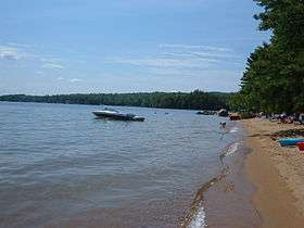 A beach in Sebago Lake State Park | |
| Location | Cumberland County, Maine |
| Coordinates | 43°51′N 70°34′W / 43.850°N 70.567°WCoordinates: 43°51′N 70°34′W / 43.850°N 70.567°W |
| Lake type | oligotrophic |
| Primary outflows | Presumpscot River |
| Catchment area | 440 square miles (1,100 km2)[1] |
| Basin countries | United States |
| Max. length | 12 mi (19 km) |
| Surface area | 30,513 acres (12,348 ha)[1] |
| Average depth | 107 ft (33 m)[1] |
| Max. depth | 316 ft (96 m)[1] |
| Water volume | 3,224,233 acre·ft (3.977033×10⁹ m3)[1] |
| Residence time | 5.1 to 5.4 yrs |
| Shore length1 | 105 miles (169 km)[2] |
| Surface elevation | 267 ft (81 m)[1] |
| Islands | Frye Island |
| Settlements | Casco, Naples, Raymond, Sebago, Standish and Windham |
| References | [1] |
| 1 Shore length is not a well-defined measure. | |

Sebago Lake is the deepest and second largest lake in the U.S. state of Maine. The lake is 316 feet (96 m) deep at its deepest point, with a mean depth of 101 feet (31 m), covers about 45 square miles (117 km2) in surface area, has a length of 12 miles (19 km) and a shoreline length of 105 miles (169 km).[2] The surface is around 270 feet (82 m) above sea level, so the deep bottom is below the present sea level.[3] It is located in Cumberland County, Maine, and bordered by the towns of Casco, Naples, Raymond, Sebago, Standish and Windham. The seasonally occupied town of Frye Island is on an island in the lake.[4]
Transportation
The lake is connected to Brandy Pond by the Songo River and eventually to Long Lake in Naples. The name comes from a local Native American tribe. The lake is drained primarily by the Presumpscot River. The lake and rivers were an early transportation corridor from the coast to the interior, and encouraged the first incorporated European settlement of interior Maine in 1762.[5] Sebago Lake was linked to Portland harbor by the Cumberland and Oxford Canal in 1832. The outlet to the Presumpscot River was controlled for the canal by the Eel Weir Dam and the Head Dam, owned and operated by the Oriental Powder Company after the canal was replaced by a railroad[6] and by the S. D. Warren Paper Mill after 1878.[2][7]
The lake was a comparatively safe place for training military pilots from NAS Brunswick about flying over water; but several navy planes were lost over the lake during World War II. A Grumman TBF Avenger from the Lewiston Naval Auxiliary Air Facility ditched and sank near Raymond on 16 August 1943. Two low-flying British Vought Corsairs from Brunswick were lost after a mid-air collision over the lake near Raymond on 16 May 1944; and a third Corsair flew into the lake on July 16.[8] In December 2014 the first Sebago Lake beach landing in the history of the world was made by a yellow Supercub.
Water Supply
Sebago Lake is the primary water supply for the Portland Water District, which serves the Greater Portland region and about 15% of Maine's population. The lake's watershed is more than 50 miles (80 km) long and covers parts of 24 Maine towns.[9]
The lake holds roughly 995 billion US gallons (3.77×10⁹ m3) of water that on average resides 5.1 to 5.4 years in the lake. The direct watershed is about 171 square miles (443 km2) of land plus the 45 square miles (117 km2) of the lake, and the indirect watershed about 190 square miles (490 km2) of land plus about 28 square miles (73 km2) of other bodies of water. As of May 1990, roughly 86% of the watershed was forests and fallow fields, 2.5% in active timber operations, 9.3% in residential, agricultural, and commercial use, and 2.2% used for other purposes. Water inflow is estimated at 544 million US gallons (2,060,000 m3) per day and outflow at 498 million US gallons (1,890,000 m3) per day, of which 24 million US gallons (91,000 m3)/day are for the water district.[2]
Recreation
In 1938, Maine opened Sebago Lake State Park as one of its original five state parks. The area was a recreation center even before this. The park is now 1,400 acres (5.7 km2) (mostly forested), open year-round, and has facilities including two public boat launches and a 250-site campground.[10] There are also numerous private campgrounds (like Point Sebago in Casco which is 775 acres (3.14 km2)), cottages, and other recreational facilities in the area.
Sebago Lake also hosts a sailing instruction and charter service and is located in what the Maine tourism industry refers to as the Western Lakes and Mountains Region.
Efforts are underway to complete the Sebago to the Sea Trail, a trail running 28 miles from Sebago Lake to Casco Bay, mostly following the path of the Presumpscot River.
Fishing
The lake contains populations of land-locked salmon (Salmo salar sebago) and smelt. When the last major glaciers retreated, the entire watershed was under seawater, and populations of these marine animals became established as the land rose and seawaters retreated.[11]
Other game fish that can be found in the lake include lake trout, brook trout, brown trout, smallmouth bass, largemouth bass, and northern pike.[12] Some of these are stocked by the state, either in the lake directly or in connected bodies of water, while others were introduced illegally.[13] The state encourages anglers to kill, hold, and notify them of all northern pike taken in the lake because they were introduced illegally, are not native to the region, and could disrupt the lake ecosystem. [14]
Camp
Center Day Camp, a day camp run by the Jewish Community Alliance of Southern Maine, is located on the shores of Sebago Lake.
Camp O-At-Ka, founded in 1906, is located along a half mile of waterfront in the northwest corner of Sebago Lake.
References
- 1 2 3 4 5 6 7 Maine Depts. of Environmental Protection and Inland Fisheries & Wildlife. "Maine Lakes: Morphometry and Geographic Information". Senator George J. Mitchell Center for Environmental and Watershed Research, The University of Maine. Retrieved 2008-07-31.
- 1 2 3 4 "Sebago Lake". Portland Water District, Portland Maine. Retrieved 2006-05-05.
- ↑ "Why is Sebago Lake so deep?". Maine Geological Survey, Department of Conservation, State of Maine. Retrieved 2006-05-05.
- ↑ "Total Phosphorus Loads for Selected Tributaries to Sebago Lake, Maine" (PDF). Water-Resources Investigations Report 01-4003. Archived from the original (PDF) on 2005-11-18. Retrieved 2006-05-05.
- ↑ Rolde, Neil (1990). Maine: A Narrative History. Gardiner, Me: Harpswell Press. pp. 84–85. ISBN 0-88448-069-0.
- ↑ "The Basin Dam War". Friends of Sebago Lake. Retrieved 2010-12-15.
- ↑ "Sebago Lake Water Level". Portland Water District, Portland Maine. Retrieved 2006-05-05.
- ↑ "The ultimate sacrifice; wreck sites a reminder of military plane disasters". Lewiston Sun Journal. Retrieved 2012-01-20.
- ↑ "Sebago Lake". Portland Water District, Portland Maine. Retrieved 2006-05-05.
- ↑ "Sebago Lake State Park". Bureau of Parks & Lands, Department of Conservation, State of Maine. Retrieved 2006-05-05.
- ↑ "Presumpscot River: Sebago Lake to Westbrook". Outdoors, MaineToday.com. Archived from the original on March 27, 2006. Retrieved 2006-05-05.
- ↑ "Sebago Lake". Sebago Lake, Casco Maine Fly Fish Waters. Archived from the original on 2007-09-26. Retrieved 2006-05-05.
- ↑ "Sebago's salmon". Outdoors, MaineToday.com. Archived from the original on 2006-03-27. Retrieved 2006-05-05.
- ↑ "Sebago Region Fisheries Newsletter". Sebago Region Fisheries Newsletter, 19th edition – December 2005. Retrieved 2006-05-05.