Naples, Maine
| Naples, Maine | |
|---|---|
| Town | |
|
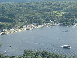
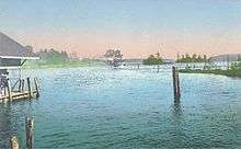
Naples from the air, with the Songo River Queen II on Long Lake and the newly-constructed causeway connecting Brandy Pond | |
| Nickname(s): "The Heart of the Lakes Region" | |
| Motto: "Welcome to Vacationland"[1] | |
 Location in Cumberland County and the state of Maine. | |
| Coordinates: 43°57′36″N 70°36′11″W / 43.96000°N 70.60306°W | |
| Country | United States |
| State | Maine |
| County | Cumberland |
| Area[2] | |
| • Total | 37.25 sq mi (96.48 km2) |
| • Land | 31.82 sq mi (82.41 km2) |
| • Water | 5.43 sq mi (14.06 km2) |
| Elevation | 315 ft (96 m) |
| Population (2010)[3] | |
| • Total | 3,872 |
| • Estimate (2012[4]) | 3,910 |
| • Density | 121.7/sq mi (47.0/km2) |
| Time zone | Eastern (EST) (UTC-5) |
| • Summer (DST) | EDT (UTC-4) |
| ZIP code | 04055 |
| Area code(s) | 207 |
| FIPS code | 23-48085 |
| GNIS feature ID | 0582613 |
| Website | Town of Naples, Maine |
Naples is a town in Cumberland County, Maine, United States. It is part of the Portland–South Portland–Biddeford, Maine metropolitan statistical area. The population was 3,872 at the 2010 census,[5] and it is home to part of Sebago Lake State Park. Naples is a resort area.
History
The area was settled in 1790. Farming was limited by the soil, which consisted of gravelly loam, its surface strewn with glacial erratic boulders. The uplands, however, provided good grazing for livestock, and hay became the principal crop.[6]
Named for Naples, Italy,[7] the town was incorporated on March 4, 1834,[8] from parts of Otisfield, Harrison, Raymond and Bridgton. Between 1845 and 1856, it annexed more land from Sebago, Otisfield and Bridgton. The Songo Lock, completed two years before town incorporation, linked Long Lake and Brandy Pond with Sebago Lake, allowing passage of boats from Harrison to Portland through the Cumberland and Oxford Canal in Standish. A canning factory and cooperage were established at Naples village. The community also produced carriages, men's and boy's clothing, boots and shoes.[9]
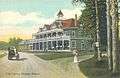
The beautiful scenery of the lakes, however, would make tourism the dominant industry. Visitors in the 19th century included Henry Wadsworth Longfellow and Nathaniel Hawthorne. To accommodate his passengers, Charles L. Goodridge of the Sebago Lake, Songo River & Bay of Naples Steamship Company built a hostelry on a knoll at the southern end of Long Lake. On July 26, 1899, the Bay of Naples Inn opened with 80 bedrooms. It was designed by John Calvin Stevens, who reduced by two-fifths a plan originally created for the ill-fated Metallak Hotel in Colebrook, New Hampshire. While under construction, the Metallak was destroyed in April 1893 during a violent windstorm, and its investors abandoned the project. The Bay of Naples Inn, which faced Mount Washington and the east side of the White Mountains, was a popular resort during the early 20th century. Automobile tourists began arriving after designation of the Theodore Roosevelt International Highway in 1919 (identified as United States Route 302 since 1935).[10] The Bay of Naples Inn remained open through the 1951 season, but in 1964 was deemed unprofitable and razed.[11]
-

Naples village c. 1920
-
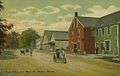
Post Office in c. 1910
-
The Casino in 1911
-

Bay of Naples Inn, 1913
Geography
According to the United States Census Bureau, the town has a total area of 37.25 square miles (96.48 km2), of which, 31.82 square miles (82.41 km2) of it is land and 5.43 square miles (14.06 km2) is water.[2] Naples is drained by the Songo River.
Water bodies that are adjacent to or within of Naples include:
Demographics
| Historical population | |||
|---|---|---|---|
| Census | Pop. | %± | |
| 1840 | 758 | — | |
| 1850 | 1,025 | 35.2% | |
| 1860 | 1,219 | 18.9% | |
| 1870 | 1,058 | −13.2% | |
| 1880 | 1,007 | −4.8% | |
| 1890 | 846 | −16.0% | |
| 1900 | 813 | −3.9% | |
| 1910 | 736 | −9.5% | |
| 1920 | 514 | −30.2% | |
| 1930 | 641 | 24.7% | |
| 1940 | 676 | 5.5% | |
| 1950 | 747 | 10.5% | |
| 1960 | 735 | −1.6% | |
| 1970 | 956 | 30.1% | |
| 1980 | 1,833 | 91.7% | |
| 1990 | 2,860 | 56.0% | |
| 2000 | 3,274 | 14.5% | |
| 2010 | 3,872 | 18.3% | |
| Est. 2014 | 3,952 | [12] | 2.1% |
2010 census
As of the census[3] of 2010, there were 3,872 people, 1,579 households, and 1,094 families residing in the town. The population density was 121.7 inhabitants per square mile (47.0/km2). There were 3,004 housing units at an average density of 94.4 per square mile (36.4/km2). The racial makeup of the town was 97.4% White, 0.3% African American, 0.2% Native American, 0.5% Asian, 0.2% from other races, and 1.4% from two or more races. Hispanic or Latino of any race were 0.7% of the population.
There were 1,579 households of which 30.4% had children under the age of 18 living with them, 53.8% were married couples living together, 10.6% had a female householder with no husband present, 4.9% had a male householder with no wife present, and 30.7% were non-families. 23.1% of all households were made up of individuals and 6.6% had someone living alone who was 65 years of age or older. The average household size was 2.45 and the average family size was 2.83.
The median age in the town was 42.9 years. 22.2% of residents were under the age of 18; 6.8% were between the ages of 18 and 24; 24.4% were from 25 to 44; 33% were from 45 to 64; and 13.6% were 65 years of age or older. The gender makeup of the town was 51.2% male and 48.8% female.
2000 census
As of the census[14] of 2000, there were 3,274 people, 1,297 households, and 931 families residing in the town. The population density was 102.9 people per square mile (39.8/km²). There were 2,381 housing units at an average density of 74.9 per square mile (28.9/km²). The racial makeup of the town was 98.20% White, 0.15% African American, 0.31% Native American, 0.31% Asian, 0.21% from other races, and 0.82% from two or more races. Hispanic or Latino of any race were 0.21% of the population.
There were 1,297 households out of which 32.1% had children under the age of 18 living with them, 58.6% were married couples living together, 8.3% had a female householder with no husband present, and 28.2% were non-families. 21.7% of all households were made up of individuals and 8.9% had someone living alone who was 65 years of age or older. The average household size was 2.52 and the average family size was 2.90.

In the town the population was spread out with 24.6% under the age of 18, 5.6% from 18 to 24, 29.8% from 25 to 44, 25.3% from 45 to 64, and 14.7% who were 65 years of age or older. The median age was 40 years. For every 100 females there were 102.3 males. For every 100 females age 18 and over, there were 97.2 males.
The median income for a household in the town was $38,141, and the median income for a family was $40,825. Males had a median income of $31,458 versus $24,596 for females. The per capita income for the town was $18,176. About 6.9% of families and 7.6% of the population were below the poverty line, including 10.4% of those under age 18 and 2.3% of those age 65 or over.
Arts and culture
Site of interest
Notable people
- Augustus Bove, state legislator with the Republican Party
- Richard Cebra, state legislator with the Maine Republican Party (2004-2012) and state Republican Party chairman (2012-2013)
- Major Knight, state legislator with the Greenback Party (1880)
- Richard Thompson, state legislator with the Maine Democratic Party (1994-2000)
- Christine Powers, state legislator with the Maine Democratic Party (2012-)
References
- ↑ "Town of Naples, Maine". Town of Naples, Maine. Retrieved August 26, 2012.
- 1 2 "US Gazetteer files 2010". United States Census Bureau. Retrieved 2012-12-16.
- 1 2 "American FactFinder". United States Census Bureau. Retrieved 2012-12-16.
- ↑ "Population Estimates". United States Census Bureau. Retrieved 2013-07-06.
- ↑ "Profile of General Population and Housing Characteristics: 2010 Demographic Profile Data (DP-1): Naples town, Cumberland County, Maine". U.S. Census Bureau, American Factfinder. Retrieved June 8, 2012.
- ↑ Coolidge, Austin J.; John B. Mansfield (1859). A History and Description of New England. Boston, Massachusetts. pp. 220–222.
- ↑ "Profile for Naples, Maine, ME". ePodunk. Retrieved August 26, 2012.
- ↑ "Naples, Maine". City-Data.com. Retrieved August 26, 2012.
- ↑ George J. Varney, "History of Naples, Maine" (1886)
- ↑ Tracy, A.W. (December 1996) [1921]. "Highway Display's America's Glories". Theodore Roosevelt International Highway, Montana (PDF). Montana Department of Transportation. p. 7. Retrieved August 21, 2008.
- ↑ Bryant F. Tolles, Jr., The Grand Resort Hotels of the White Mountains; David R. Godine, publisher; Boston 1998
- ↑ "Annual Estimates of the Resident Population for Incorporated Places: April 1, 2010 to July 1, 2014". Retrieved June 4, 2015.
- ↑ "Census of Population and Housing". Census.gov. Retrieved June 4, 2015.
- ↑ "American FactFinder". United States Census Bureau. Retrieved 2008-01-31.
External links
- Town of Naples official website
- Naples Public Library
- Muddy River Sno Seekers Snowmobile Club
- Sebago Lake State Park
- Maine Genealogy: Naples, Cumberland County, Maine
Municipalities and communities of Cumberland County, Maine, United States | ||
|---|---|---|
| Cities | 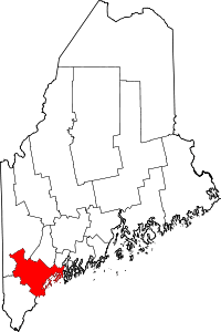 | |
| Towns | ||
| CDPs | ||
| Other villages | ||
Coordinates: 43°58′18″N 70°36′33″W / 43.97167°N 70.60917°W