Ap Lei Chau Bridge
| Ap Lei Chau Bridge 鴨脷洲大橋 | |
|---|---|
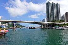
 Ap Lei Chau Bridge viewed from the north. Jumbo Kingdom is visible underneath the central span and Ocean Park in the distance. | |
| Coordinates | 22°14′45″N 114°09′35″E / 22.245877°N 114.159704°E |
| Carries | Ap Lei Chau Bridge Road |
| Crosses | Aberdeen Channel |
| Locale | Ap Lei Chau and Aberdeen, Hong Kong |
| Characteristics | |
| Design | Box girder bridge |
| Total length | 230 m (750 ft) |
| Clearance below | 14 m (46 ft) |
| History | |
| Construction begin | 1977 (first bridge) |
| Construction cost | HK$64,000,000 |
| Opened | 28 March 1980 (first bridge) and 28 July 1994 (duplicate bridge) |
| Statistics | |
| Toll | Free of charge |
Ap Lei Chau Bridge (traditional Chinese: 鴨脷洲大橋; simplified Chinese: 鸭脷洲大桥; Cantonese Yale: ngaap3 lei6 jau1 daai6 kiu4; pinyin: Yālìzhōu Dàqiáo) is a highway bridge in Hong Kong connecting the island of Ap Lei Chau (Aberdeen Island) to the community of Aberdeen on Hong Kong Island.
The original bridge carried one lane of traffic in each direction. Construction of a twin bridge (the Ap Lei Chau Second Bridge) to its north was started in May 1991 and completed in July 1994, so that there are now two lanes in each direction.[1][2] The bridge is Ap Lei Chau's only road connection to Hong Kong Island, though it will not be the only fixed link for long as a second bridge, the Aberdeen Channel Bridge, to be used by MTR's South Island Line is under construction and will be put into use by 2017.
Legislators approved funding for the Second Ap Lei Chau Bridge on 6 March 1992.[3] It opened on 28 July 1994.[4] The first person to drive across it was Kwong Hong-sang, Director of Highways, officiating at the opening ceremony.[4]
See also
| Wikimedia Commons has media related to Ap Lei Chau Bridge. |
References
- ↑ 景點 [Attractions] (in Chinese). Apleichau Promotion of Tourism Association. Retrieved 2015-05-13.
- ↑ "Roads in Hong Kong Island". Hong Kong Highways Department. Retrieved 2015-05-13.
- ↑ Lau, Jeremy (7 March 1992). "Go-ahead for bridge plan". South China Morning Post. p. 5.
- 1 2 Ball, Steve (28 July 1994). "New bridge prepares to take the strain". South China Morning Post. p. 3.
Coordinates: 22°14′45″N 114°9′36″E / 22.24583°N 114.16000°E