Nuthurst
| Nuthurst | |
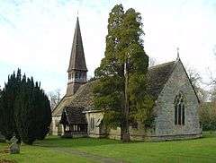 St Andrew's Church |
|
 Nuthurst |
|
| Area | 16.97 km2 (6.55 sq mi) [1] |
|---|---|
| Population | 1,711 [1] 2001 Census 1,777 (civil parish 2011)[2] |
| – density | 101/km2 (260/sq mi) |
| OS grid reference | TQ192261 |
| – London | 34 miles (55 km) NNE |
| Civil parish | Nuthurst |
| District | Horsham |
| Shire county | West Sussex |
| Region | South East |
| Country | England |
| Sovereign state | United Kingdom |
| Post town | HORSHAM |
| Postcode district | RH13 |
| Dialling code | 01403 |
| Police | Sussex |
| Fire | West Sussex |
| Ambulance | South East Coast |
| EU Parliament | South East England |
| UK Parliament | Horsham |
|
|
Coordinates: 51°01′21″N 0°18′03″W / 51.02263°N 0.30076°W
Nuthurst is a village and civil parish in the Horsham District of West Sussex, England. The north of the parish borders Horsham town, with Nuthurst village 3 miles (5 km) south from the border.
Parish land area is 1697 hectares (4191 acres). In the 2001 census 1711 people lived in 702 households, of whom 875 were economically active. At the 2011 Census the population had increased slightly to 1,777.[2]
Apart from Nuthurst village, the parish contains dispersed farms and residential properties, the village of Mannings Heath, the largest settlement, and the hamlets of Copsale, Monk's Gate, Maplehurst, and Sedgwick. Sedgwick Park, approximately 2 miles (3 km) south from Horsham, is a largely nineteenth–century house but with one wing possibly dating from 1608.[3] In the grounds are the fragmentary remains of the medieval Sedgwick Castle, surrounded by a now mostly dry moat.[4]
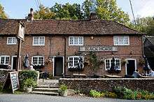
The Church of England parish church of St Andrews is within Nuthurst village, and has links with the nearby St Andrews C of E–aided school. Public houses in the parish are The Black Horse Inn, Nuthurst village, The White Horse Inn, Maplehurst, and The Dun Horse Inn, Mannings Heath.
References
- 1 2 "2001 Census: West Sussex – Population by Parish" (PDF). West Sussex County Council. Retrieved 12 April 2009.
- 1 2 "Civil Parish population 2011". Neighbourhood Statistics. Office for National Statistics. Retrieved 2 October 2016.
- ↑ "Sedgwick Park". British Listed Buildings. Retrieved 17 June 2011.
- ↑ "Sedgwick Castle". Pastscape. Retrieved 17 June 2011.
External links
 Media related to Nuthurst at Wikimedia Commons
- Nuthurst Parish Council website
- GENUK map of sussex parishes