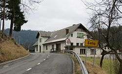
Selo, Žiri
| Selo | |
|---|---|
 | |
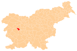
 Selo Location in Slovenia | |
| Coordinates: 46°3′49.21″N 14°5′55.3″E / 46.0636694°N 14.098694°ECoordinates: 46°3′49.21″N 14°5′55.3″E / 46.0636694°N 14.098694°E | |
| Country |
|
| Traditional region | Upper Carniola |
| Statistical region | Upper Carniola |
| Municipality | Žiri |
| Area | |
| • Total | 1.26 km2 (0.49 sq mi) |
| Elevation | 491.4 m (1,612.2 ft) |
| Population (2002) | |
| • Total | 279 |
| [1] | |
Selo (pronounced [ˈsɛːlɔ]) is a settlement on the right bank of the Poljane Sora River (Slovene: Poljanska Sora) north of Žiri in the Upper Carniola region of Slovenia.[2]
References
External links
| Settlements | Administrative centre: Žiri
|  | ||||||
|---|---|---|---|---|---|---|---|---|
| Landmarks |
| |||||||
| Notable people | ||||||||
This article is issued from Wikipedia - version of the 11/20/2016. The text is available under the Creative Commons Attribution/Share Alike but additional terms may apply for the media files.