Sgùrr na Cìche
| Sgùrr na Cìche | |
|---|---|
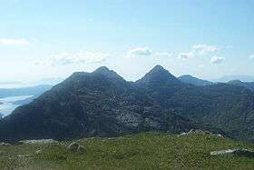 Garbh Cìoch Mhòr and Sgùrr na Cìche seen from Sgùrr nan Coireachan to the west. | |
| Highest point | |
| Elevation | 1,040 m (3,410 ft) [1] |
| Prominence | 839 m (2,753 ft) Ranked 25th in British Isles |
| Parent peak | Carn Eige |
| Listing | Marilyn, Munro |
| Naming | |
| Translation | Rocky peak of the breast (Gaelic) |
| Pronunciation | Scottish Gaelic: [ˈs̪kuːrˠ nə ˈkʰʲiːçə] |
| Geography | |
| Location | Knoydart, Scotland |
| OS grid | NM902966 |
| Topo map | OS Landranger 33, 40 |
Sgùrr na Cìche is a mountain in the Knoydart region, in the west of Scotland. It lies on the edge of Knoydart in an area known as the Rough Bounds of Knoydart.
The peak has a distinctive pointy shape, making it a recognisable object in views from many of Scotland's mountains, including Càrn Eige and Ben Nevis. Its close neighbours include Ladhar Bheinn and The Saddle, but thanks to the deep gulf separating it from them, it has a high prominence — the 25th highest in Britain.
Sgùrr na Cìche may be climbed from the head of Loch Nevis on the southern side of Knoydart by following the ridge of Druim a' Ghoirtein. However, due to the remoteness of the Knoydart peninsula, it is more commonly climbed as part of a circuit from the head of Glen Dessarry, via a route that also takes in the neighbouring Munros of Garbh Cìoch Mhòr and Sgùrr nan Coireachan.
References
- Translation and pronunciation information come from this page
- This list gives information about map, grid ref and neighbours
- The Munros: Scottish Mountaineering Club Hillwalkers Guide, by Donald J. Bennet. ISBN 0-907521-57-6
Citations
- ↑ "walkhighlands Sgurr na Ciche". walkhighlands.co.uk. 2014. Retrieved 9 January 2014.
External links
| Wikimedia Commons has media related to Sgurr na Cìche. |
- Computer generated digital panoramas Sgùrr na Cìche Index
 |
|  | |
| Northern Highlands |    | |
|---|---|---|
| Western Highlands | ||
| Central and Eastern Highlands | ||
| Southern Highlands | ||
| Islands | ||
| Scottish Lowlands, England and Wales | ||
Coordinates: 57°00′46″N 5°27′26″W / 57.01270°N 5.45718°W