Sherston, Wiltshire
| Sherston | |
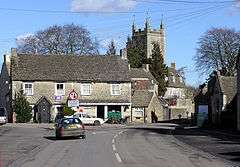 Post office and parish church |
|
 Sherston |
|
| Population | 1,639 (in 2011)[1] |
|---|---|
| OS grid reference | ST853859 |
| Civil parish | Sherston |
| Unitary authority | Wiltshire |
| Ceremonial county | Wiltshire |
| Region | South West |
| Country | England |
| Sovereign state | United Kingdom |
| Post town | Malmesbury |
| Postcode district | SN16 |
| Dialling code | 01666 |
| Police | Wiltshire |
| Fire | Dorset and Wiltshire |
| Ambulance | South Western |
| EU Parliament | South West England |
| UK Parliament | North Wiltshire |
| Website | Parish Council |
Coordinates: 51°34′19″N 2°12′47″W / 51.572°N 2.213°W
Sherston is a village and civil parish about 5 miles (8 km) west of Malmesbury in Wiltshire, England. The parish is bounded to the north by the county boundary with Gloucestershire, and to the southeast by the Fosse Way, a Roman road. The parish includes the hamlets of Easton Town, immediately east of Sherston; Pinkney, further east along the Malmesbury road; and Willesley, to the north.
The infant River Avon passes Sherston, Easton Town and Pinkney, on its way to Malmesbury. The parish lies within the Cotswolds Area of Outstanding Natural Beauty.
History
The earliest surviving record of Sherston, then called Scorranstone, is an Anglo-Saxon one from the time of Ethelred, who was an Ealdorman of Mercia. Evidence of Roman survives in the parish in the form of ramparts and ditches in a field called Pennymead, which is now the recreation ground. Remains of a Roman villa, built around AD 350, have also been discovered. The Fosseway, a major Roman road, passes nearby.
In 1016 Cnut the Great and his army fought a West Saxon army in a two-day battle on the hills around Sherston. John Rattlebone of Sherston was the leader of the local militia and is now a symbol of Sherston and its community. His name is celebrated in a local pub, the Rattlebone Inn. In 1511 a fire destroyed most of Sherston.
Pinkney was also called Sherston Parva, meaning Little Sherston. The Ordnance Survey map from the 1890s has "Great Sherston" and "Sherston Parva or Pinkney";[2] by 1951 Great Sherston had become Sherston but both names were still shown for the smaller place.[3]
The old part of the village is laid out around a broad High Street. Much of it is in a conservation area. The newer parts of the village are late 20th and early 21st century.
Governance
The civil parish elects a parish council. It is in the area of Wiltshire Council unitary authority, which performs most significant local government functions.
An electoral ward with the same name exists, consisting of the parishes of Luckington, Sherston, Sopworth, Easton Grey, Norton, St Paul Malmesbury Without, and Brokenborough. The population of the ward at the 2011 census was 4,822.[4]
Religious sites
A Congregational church was licensed at Cliff Road in 1825.[5] It remained in use until c. 2013 and was sold for residential use.
A Primitive Methodist chapel was opened at Grove Lane in 1851, and became Sherston Methodist Church in 1932 after the union of the Primitive Methodists with the Wesleyan Methodists. The church is still in use.[6]
The Church of England parish church of the Holy Cross dates from the 13th century and has a high tower which was rebuilt in 1733. The church is Grade I listed.
Notable buildings
Sherston village has two groups of Grade II* listed buildings. On the High Street, Old Swan House[7] and numbers 19 and 21[8] comprise the former Swan Inn, from the late 16th century.
Court House in Court Street[9] and the adjoining houses at 1 and 3 Cliff Road[10] were rebuilt c. 1680; for a time part of the ground floor of Court House served as the village shop.
Schools
Members of the Congregational chapel built a British School Room at Cliff Road in 1844. Its pupils were transferred to the National School in 1895 and the building has served various community purposes; in 2015 it was a meeting room and club room.[11]
A National School was opened near the Rattlebone Inn in 1846. It became a Church of England school and was extended in 1895.[12] Children of all ages were educated until 1954 when it became a junior school. Growth in pupil numbers led to the building of a new school on the outskirts of the village, which was opened in 2005.[13] The old school was bought by the parish council in 2011 and is home to shops and businesses, including the Post Office Stores.[14]
Amenities
Every year on the Saturday closest to 14 July a carnival is held. The main attraction is a boules tournament and a music evening with local bands.
Sherston has a football team, a cricket team and Scout troop. There are two pubs, the Rattlebone and the Carpenters Arms
The village has a shop and post office, and a pub, the Rattlebone Inn. Another pub, the Holford Arms, is in the extreme northwest of the parish at Knockdown, Gloucestershire.
Notable people
In the 1970s and 1980s Sherston was the home of eccentric socialite Lady Edith Foxwell, and her friend the soul singer Marvin Gaye was a frequent visitor. Until his death in 2002, the actor John Thaw lived nearby with his wife, the actress Sheila Hancock.
Economy
The village is the home of Sherston Software, makers of educational games.
References
- ↑ "Wiltshire Community History – Census". Wiltshire Council. Retrieved 20 January 2016.
- ↑ "Sherston". Wiltshire Community History. Wiltshire Council. Retrieved 21 January 2016.
- ↑ "Ordnance Survey 1:25,000 maps of Great Britain, sheet ST88". National Library of Scotland. Retrieved 21 January 2016.
- ↑ "Sherston ward – 2011 Census". Neighbourhood Statistics. Office for National Statistics. Retrieved 20 January 2016.
- ↑ "Congregational Chapel, Sherston". Wiltshire Community History. Wiltshire Council. Retrieved 23 January 2016.
- ↑ "Methodist Chapel, Sherston". Wiltshire Community History. Wiltshire Council. Retrieved 23 January 2016.
- ↑ Historic England. "Old Swan House (1355982)". National Heritage List for England. Retrieved 25 January 2016.
- ↑ Historic England. "19 and 21, High Street (1023244)". National Heritage List for England. Retrieved 25 January 2016.
- ↑ Historic England. "Court House (1023232)". National Heritage List for England. Retrieved 25 January 2016.
- ↑ Historic England. "1 and 3, Cliff Road (1283388)". National Heritage List for England. Retrieved 25 January 2016.
- ↑ "British School, Sherston". Wiltshire Community History. Wiltshire Council. Retrieved 23 January 2016.
- ↑ Historic England. "Sherston Church of England School (1390514)". National Heritage List for England. Retrieved 23 January 2016.
- ↑ "Sherston Church of England Primary School". Wiltshire Community History. Wiltshire Council. Retrieved 23 January 2016.
- ↑ Robins, Tina (12 October 2012). "Sherston Old School volunteers recognised". Wilts and Gloucestershire Standard. Retrieved 23 January 2016.
External links
![]() Media related to Sherston, Wiltshire at Wikimedia Commons
Media related to Sherston, Wiltshire at Wikimedia Commons