Shevchenkivskyi District, Dnipro
| Shevchenkivskyi District Шевченківський район | ||
|---|---|---|
| Urban district | ||
| ||
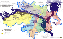 Map of the urban districts of Dnipropetrovsk. | ||
| Coordinates: 48°31′16″N 34°58′42″E / 48.52111°N 34.97833°ECoordinates: 48°31′16″N 34°58′42″E / 48.52111°N 34.97833°E | ||
| Country |
| |
| Municipality | Dnipropetrovsk Municipality | |
| Established | 12 April 1973[1] | |
| Government | ||
| • Chairman of District Council | Oleh Yurashko | |
| Area | ||
| • Total | 31 km2 (12 sq mi) | |
| Population (2001 census) | ||
| • Total | 159,914 | |
| • Density | 5,200/km2 (13,000/sq mi) | |
| Time zone | EET (UTC+2) | |
| • Summer (DST) | EEST (UTC+3) | |
| Area code | +380 562 | |
| KOATUU | 1210136600[2] | |
| Website |
babushkinskarada | |
For other uses, see Shevchenko Raion.
Shevchenkivskyi District (Ukrainian: Шевченківський район) is a right-bank urban district of the city of Dnipropetrovsk, located in southern Ukraine.[3]
It was formed on 12 April 1973 from the territory of Zhovtnevyi, Kirovskyi and Krasnohvardiiskyi districts and was named after Russian Bolshevik revolutionary Ivan Babushkin. On 26 November 2015 the district was renamed by the Dnipropetrovsk city council to its current name to comply with decommunization laws.[4]
Notable places
- Dnipropetrovsk Main Post Office
- Dnipropetrovsk City Council
- Holy Trinity Orthodox Cathedral
Neighborhoods
- Centre (TsUM)
- Pidstantsiia
- 12th Kvartal
- Topolia
- Koreia
- Myrne
Main streets
- Prospekt Dmytra Yavornytskoho (Dmytro Yavornytsky Avenue), former Yekaterininsky and Karla Marksa
- Sicheslavska naberezhna (Sicheslav Embankment), former Naberezhna Lenina
- Vulytsia Sviatoslava Khorobroho (Sviatoslav the Brave Street), former Bazarna and Chkalova
- Vulytsia Mykhaila Hrushevskoho (Mykhailo Hrushevsky Street), former Kazanska and Karla Libknekhta
- Vulytsia Sichovykh Striltsiv (Sich Riflemen Street), former Oleksandrivska and Artema
- Prospekt Bohdana Khmelnytskoho (Bohdan Khmelnytsky Avenue), former Dnipropetrovska street and Heroiv Stalinhrada street
- Vulytsia Panikakhy (Panikakha Street)
- Zaporizke Shose (Zaporizhzhia Chaussée)
Gallery
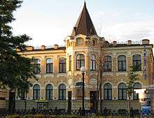 Dnipropetrovsk Main Post Office
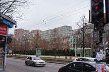 Dmytro Yavornytsky Avenue in Shevchenkivskyi District
References
- ↑ "Babushkinskyi Raion". Official Internet-portal (in Ukrainian). Dnipropetrovsk City Council. Retrieved 2 February 2015.
- ↑ "Industrialyni District Council". Informational portal of the self-government in Ukraine (in Ukrainian). Rada.info. Retrieved 5 February 2015.
- ↑ "Babushkinskyi Raion, Dnipropetrovsk Oblast, City of Dnipropetrovsk". Regions of Ukraine and their Structure (in Ukrainian). Verkhovna Rada of Ukraine. Retrieved 2 February 2015.
- ↑ (Ukrainian) Street signs were Dnipropetrovsk nedekomunizovanymy, Radio Svoboda (2 December 2015)
| Raions | |||||||
|---|---|---|---|---|---|---|---|
| Cities | |||||||
| Urban-type settlements | |||||||
| Neighborhoods |
| ||||||
| |||||||
This article is issued from Wikipedia - version of the 5/29/2016. The text is available under the Creative Commons Attribution/Share Alike but additional terms may apply for the media files.