Shipmeadow
| Shipmeadow | |
 Shipmeadow |
|
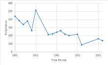
| Population | 140 (2011 census) |
|---|---|
| OS grid reference | TM382900 |
| District | Waveney |
| Shire county | Suffolk |
| Region | East |
| Country | England |
| Sovereign state | United Kingdom |
| Post town | Beccles |
| Postcode district | NR34 8 |
| EU Parliament | East of England |
Coordinates: 52°27′22″N 1°30′18″E / 52.456°N 1.505°E
.jpg)
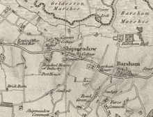
Shipmeadow is a small village located on the Beccles to Bungay road.[1] The village is located in the County of Suffolk. Shipmeadow has no shop or even a church because it was made redundant in 1980. Of the village's 140 population, 69 are male and 71 are female according to the 2011 Census.[2] Norwich is located approximately 14.9 miles (24.1 km) NW of Shipmeadow as the crow flies and Great Yarmouth is located 13.7 miles (22.1 km) NE of the village.[3] The River Waveney runs to the North of the village and feeds into the River Yare to the East. 'The White house' and the River Waveney define the North and Western boundaries of the settlement while the boundary to the South is the area between Shipmeadow Common and Hawthorne Farm.
History
Shipmeadow is recorded in the domesday book as Scitmetdua or Scipmedu. This settlement appears on the John Speed's 1610 map as Shepemeadow. This shows that the name has more likely to be sheep meadow rather than the current Shipmeadow.
In the 1870s, John Marius Wilson made the following notes about Shipmeadow:
'Shipmeadow, a parish, with a village, in Wangford district, Suffolk; 2½ miles W by S of Beccles r. station. It has a post-office under Beccles. The church was repaired in 1856. The Wangford workhouse is here, has accommodation for about 400 inmates.'[4]
Industry
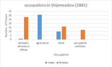
Historically, Shipmeadow's primary industry has been agriculture due to its rural location. During 1881 the three most popular occupations were Agriculture with 31 workers, Domestic Services with 29 workers and textile services with 7 workers.[5] According to the 2011 Census, the top three industries in Shipmeadow were Human Health and Social Work with 14 workers, Wholesale and retail trade with 11 workers and Agriculture with 6 workers.[6]
Transport
The B1062 road runs through Shipmeadow, linking it to Beccles to the East and Bungay to the West. The A143 and A146 run to the North of the village and provide a route to Great Yarmouth and Lowestoft. The nearest train station to the Village is located within Beccles about 3.5 Miles away. The nearest international airport to Shipmeadow is in Norwich, to the North.
Sport and Leisure
Beccles Sports Centre provides the nearest sports facilities for Shipmeadow including gym equipment, Badminton Courts and dance classes.[7] The nearest football club to Shipmeadow is again located in Beccles in the form of Beccles Town F.C. who play at College Meadow football pitch.[8]
References
- ↑ Kelly, E. R., ed. (1875). "SHIPMEADOW". The Post Office Directory of Cambridge, Norfolk and Suffolk. London: Kelly & Co. p. 908.
- ↑ "Shipmeadow (Parish): Key Figures for 2011 Census: Key Statistics". Neighbourhood Statistics. Office for National Statistics. Retrieved 2016-08-31.
- ↑ GENUKI. "Genuki: Shipmeadow, Suffolk". www.genuki.org.uk. Retrieved 2016-02-25.
- ↑ Wilson, John Marius (1870–72). Imperial Gazetteer of England and Wales. Edinburgh: A. Fullerton & Co.
- ↑ "Shipmeadow CP/AP through time - Industry Statistics - Occupation data". www.visionofbritain.org.uk. Retrieved 2016-04-21.
- ↑ "Census data, 2011". Retrieved 2016-04-21.
- ↑ "Beccles Sports Centre | Suffolk Infolink". infolink.suffolk.gov.uk. Retrieved 2016-04-24.
- ↑ "Find Us - Beccles Town Football Club". www.becclestownfc.org.uk. Retrieved 2016-04-24.
External links
- Workhouse Chapel of St James, Shipmeadow Suffolk Churches